Tynda
Tynda
Тында | |
|---|---|
Town[1] | |
 Residential buildings in Tynda | |
 Flag  Coat of arms | |
show Location of Tynda | |
 Tynda Location of Tynda | |
| Coordinates: 55°10′N 124°43′E / 55.167°N 124.717°ECoordinates: 55°10′N 124°43′E / 55.167°N 124.717°E | |
| Country | Russia |
| Federal subject | Amur Oblast[1] |
| Founded | 1917 |
| Town status since | November 14, 1975 |
| Government | |
| • Head | Mark Shults |
| Area | |
| • Total | 124 km2 (48 sq mi) |
| Elevation | 520 m (1,710 ft) |
| Population | |
| • Total | 36,275 |
| • Estimate (2018)[4] | 33,061 (−8.9%) |
| • Density | 290/km2 (760/sq mi) |
Administrative status | |
| • Subordinated to | Tynda Urban Okrug[1] |
| • Capital of | Tynda Urban Okrug[1], Tyndinsky District[1][5] |
Municipal status | |
| • Urban okrug | Tynda Urban Okrug[6] |
| • Capital of | Tynda Urban Okrug[6], Tyndinsky District[5] |
| Time zone | UTC+9 (MSK+6 |
| Postal code(s)[8] | 676280–676290 |
| Dialing code(s) | +7 41656 |
| OKTMO ID | 10732000001 |
| Website | web |


Tynda (Russian: Ты́нда) is a town in Amur Oblast, Russia, located 568 kilometers (353 mi) northwest of Blagoveshchensk. It is an important railway junction, informally referred to as the capital of the Baikal-Amur Mainline. Its population has declined sharply in recent years: 36,275 (2010 Census);[3] 40,094 (2002 Census);[9] 61,996 (1989 Census).[10]
Etymology[]
The name is of Evenk origin and is roughly translated as "on the river bank".[11]
Geography[]
The town is located at an elevation of 500 meters (1,600 ft) above sea level, near where the joins the , after which the town was named. The Tynda then flows into the Gilyuy, a tributary of the Zeya, a few kilometers east of the town.
History[]
The settlement of Shkaruby was founded in 1917 on the present site of Tynda, as a rest stop and winter camp on the route from the Amur to the newly discovered gold fields on the Timpton River, a tributary of the Aldan.[12] In 1928, in conjunction with construction of the highway to Yakutsk, it was renamed Tyndinsky (Ты́ндинский).
In 1932, plans for what would eventually become the Baikal-Amur Mainline (BAM) named Tynda as a possible future hub station. A 180-kilometer (110 mi) long rail line, connecting Tynda with BAM station (known as Bamovskaya) near Skovorodino on the Trans-Siberian Railway was constructed between 1933 and 1937, although this was then dismantled during World War II and the rails reused for other projects closer to the front. In 1941, Tynda was granted urban-type settlement status.[2]
The revival of the construction of the BAM as an All-Union Komsomol Project in the early 1970s saw the reconstruction of the rail line between Bamovskaya and Tyndinsky, followed by the construction of the BAM east and west of the town. The settlement and its hub station were placed under the patronage of Komsomol brigades from Moscow, befitting its status as symbolic capital of the BAM. As its population grew due to the construction, the settlement was granted town status and received its present name on November 14, 1975.[citation needed]
The Amur Yakutsk Mainline (AYaM) also began construction from Tynda, with the section to Neryungri completed in 1977. The AYaM currently sees passenger services as far as Tommot in the Sakha Republic, with completion to Yakutsk expected in 2013.
The full extent of the BAM opened for full use in 1989, with the exception of the Severomuysky Tunnel. Tynda went into a decline after the BAM was completed, as the utilization of the mainline turned out to be low. Tynda's population has dropped by over 30% since the dissolution of the Soviet Union, from a high of 61,996 inhabitants recorded in the 1989 Soviet Census, to an estimated population of around 38,000 in 2008.[13]
Climate[]
Tynda has a subarctic climate (Köppen climate classification Dwc) with severely cold, rather dry winters and warm, very rainy summers.
| hideClimate data for Tynda | |||||||||||||
|---|---|---|---|---|---|---|---|---|---|---|---|---|---|
| Month | Jan | Feb | Mar | Apr | May | Jun | Jul | Aug | Sep | Oct | Nov | Dec | Year |
| Record high °C (°F) | 0.0 (32.0) |
−0.5 (31.1) |
12.4 (54.3) |
25.3 (77.5) |
34.0 (93.2) |
35.2 (95.4) |
37.2 (99.0) |
34.4 (93.9) |
28.2 (82.8) |
20.2 (68.4) |
6.2 (43.2) |
0.0 (32.0) |
37.2 (99.0) |
| Average high °C (°F) | −23.0 (−9.4) |
−16.0 (3.2) |
−6.1 (21.0) |
4.1 (39.4) |
13.9 (57.0) |
22.1 (71.8) |
24.3 (75.7) |
21.5 (70.7) |
13.7 (56.7) |
1.4 (34.5) |
−13.7 (7.3) |
−23.4 (−10.1) |
1.6 (34.9) |
| Daily mean °C (°F) | −29.0 (−20.2) |
−24.0 (−11.2) |
−14.8 (5.4) |
−3.0 (26.6) |
6.6 (43.9) |
14.4 (57.9) |
17.2 (63.0) |
14.3 (57.7) |
6.7 (44.1) |
−5.6 (21.9) |
−20.2 (−4.4) |
−28.7 (−19.7) |
−5.5 (22.1) |
| Average low °C (°F) | −35.1 (−31.2) |
−32.0 (−25.6) |
−23.5 (−10.3) |
−10.1 (13.8) |
−0.7 (30.7) |
6.6 (43.9) |
10.0 (50.0) |
7.1 (44.8) |
−0.4 (31.3) |
−12.5 (9.5) |
−26.8 (−16.2) |
−34.0 (−29.2) |
−12.6 (9.3) |
| Record low °C (°F) | −50.0 (−58.0) |
−49.0 (−56.2) |
−42.2 (−44.0) |
−35.0 (−31.0) |
−12.8 (9.0) |
−3.9 (25.0) |
−1.1 (30.0) |
−6.0 (21.2) |
−15.0 (5.0) |
−32.5 (−26.5) |
−45.0 (−49.0) |
−48.9 (−56.0) |
−50.0 (−58.0) |
| Average precipitation mm (inches) | 11.4 (0.45) |
11.9 (0.47) |
19.7 (0.78) |
38.3 (1.51) |
74.7 (2.94) |
125.2 (4.93) |
123.3 (4.85) |
143.4 (5.65) |
76.4 (3.01) |
42.8 (1.69) |
23.4 (0.92) |
19.5 (0.77) |
710 (27.97) |
| Average relative humidity (%) | 75.2 | 68.1 | 62.4 | 58.3 | 59.1 | 66.4 | 74.9 | 77.9 | 72.5 | 71.2 | 76.6 | 76.2 | 69.9 |
| Source: climatebase.ru (1948-2011)[14] | |||||||||||||
Administrative and municipal status[]
Within the framework of administrative divisions, Tynda serves as the administrative center of Tyndinsky District,[5] even though it is not a part of it.[1] As an administrative division, it is incorporated separately as Tynda Urban Okrug — an administrative unit with the status equal to that of the districts.[1] As a municipal division, this administrative unit also has urban okrug status.[6]
Demographics[]
Russians, Ukrainians, and Belarusians make up the majority of the town's population. Around 1,500 North Korean loggers worked in the region as of 2007, strictly prohibited from speaking with journalists and residing in isolated camps which are closed to all other people.[citation needed]
Economy and transportation[]
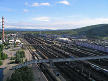
Tynda is the crossing point for the Baikal-Amur Mainline and Amur Yakutsk Mainline railways, the town's station is one of the most important on both lines and possesses a large locomotive depot.
Other than railway-related activities, the town's economy relies largely on the timber industry, with the Tyndales corporation based here. The M56 motorway to Yakutsk also passes through the town.
The town is served by the Tynda Airport, located 15 kilometers (9.3 mi) to the north. After being closed for a number of years, air services from Blagoveshchensk via Zeya resumed in 2007.[15]
International relations[]
Twin towns and sister cities[]
Tynda is twinned with:
 Wenatchee, Washington, United States
References[]
Notes[]
- ^ Jump up to: a b c d e f g Law #127-OZ
- ^ Jump up to: a b Народная энциклопедия городов и регионов России
- ^ Jump up to: a b Russian Federal State Statistics Service (2011). Всероссийская перепись населения 2010 года. Том 1 [2010 All-Russian Population Census, vol. 1]. Всероссийская перепись населения 2010 года [2010 All-Russia Population Census] (in Russian). Federal State Statistics Service.
- ^ "26. Численность постоянного населения Российской Федерации по муниципальным образованиям на 1 января 2018 года". Federal State Statistics Service. Retrieved January 23, 2019.
- ^ Jump up to: a b c Law #32-OZ
- ^ Jump up to: a b c Law #414-OZ
- ^ "Об исчислении времени". Официальный интернет-портал правовой информации (in Russian). June 3, 2011. Retrieved January 19, 2019.
- ^ Почта России. Информационно-вычислительный центр ОАСУ РПО. (Russian Post). Поиск объектов почтовой связи (Postal Objects Search) (in Russian)
- ^ Russian Federal State Statistics Service (May 21, 2004). Численность населения России, субъектов Российской Федерации в составе федеральных округов, районов, городских поселений, сельских населённых пунктов – районных центров и сельских населённых пунктов с населением 3 тысячи и более человек [Population of Russia, Its Federal Districts, Federal Subjects, Districts, Urban Localities, Rural Localities—Administrative Centers, and Rural Localities with Population of Over 3,000] (XLS). Всероссийская перепись населения 2002 года [All-Russia Population Census of 2002] (in Russian).
- ^ Всесоюзная перепись населения 1989 г. Численность наличного населения союзных и автономных республик, автономных областей и округов, краёв, областей, районов, городских поселений и сёл-райцентров [All Union Population Census of 1989: Present Population of Union and Autonomous Republics, Autonomous Oblasts and Okrugs, Krais, Oblasts, Districts, Urban Settlements, and Villages Serving as District Administrative Centers]. Всесоюзная перепись населения 1989 года [All-Union Population Census of 1989] (in Russian). Институт демографии Национального исследовательского университета: Высшая школа экономики [Institute of Demography at the National Research University: Higher School of Economics]. 1989 – via Demoscope Weekly.
- ^ Почему город Тында называется Тындой
- ^ http://www.teleport2001.ru/sever-teleport/2011-09-08/26990-tynda-na-poroge-zrelosti-na-gryadushchih-vyhodnyh-gorodu-ispolnyaetsya-36-let.html
- ^ "In pictures: Siberian showcase's decline". BBC. July 27, 2007. Retrieved December 27, 2009.
- ^ "Bagdarin, Russia". Retrieved January 19, 2013.
- ^ Interrupted flight Archived September 3, 2011, at the Wayback Machine in the Amurskaya Pravda, August 25, 2007 (Russian)
Sources[]
- Амурский областной Совет народных депутатов. Закон №127-ОЗ от 23 декабря 2005 г. «О порядке решения вопросов административно-территориального устройства Амурской области», в ред. Закона №272-ОЗ от 11 ноября 2013 г. «О внесении изменений в Закон Амурской области "О порядке решения вопросов административно-территориального устройства Амурской области"». Вступил в силу со дня первого официального опубликования, за исключением подпункта "б" пункта 2 статьи 7, вступающего в силу с 1 января 2006 г. Опубликован: "Амурская правда", №11, 24 января 2006 г. (Amur Oblast Council of People's Deputies. Law #127-OZ of December 23, 2005 On the Procedures of Handling the Issues of the Administrative and Territorial Structure of Amur Oblast, as amended by the Law #272-OZ of November 11, 2013 On Amending the Law of Amur Oblast "On the Procedures of Handling the Issues of the Administrative and Territorial Structure of Amur Oblast". Effective as of the day of the first official publication, with the exception of subitem "b" of item 2 of Article 7, which is effective January 1, 2006.).
- Амурский областной Совет народных депутатов. Закон №414-ОЗ от 19 января 2005 г. «О наделении муниципального образования города Тында статусом городского округа и об установлении его границ», в ред. Закона №100-ОЗ от 5 декабря 2005 г «Об образовании Беленького сельсовета в Тындинском районе и внесении изменений в отдельные Законы области по вопросам административно-территориального устройства области». Вступил в силу по истечении десяти дней со дня первого официального опубликования. Опубликован: "Амурская правда", №19–20, 26 января 2005 г. (Amur Oblast Council of People's Deputies. Law #414-OZ of January 19, 2005 On Granting the Municipal Formation of the Town of Tynda the Urban Okrug Status and on Establishing Its Borders, as amended by the Law #100-OZ of December 5, 2005 On Establishing Belenky Selsoviet in Tyndinsky District and on Amending Several Laws of the Oblast on the Administrative-Territorial Structure of the Oblast. Effective as of the day after ten days from the day of the first official publication have passed.).
- Амурский областной Совет народных депутатов. Закон №32-ОЗ от 3 августа 2005 г. «Об установлении границ и наделении соответствующим статусом муниципального образования Тындинского района и муниципальных образований в его составе», в ред. Закона №100-ОЗ от 5 декабря 2005 г «Об образовании Беленького сельсовета в Тындинском районе и внесении изменений в отдельные Законы области по вопросам административно-территориального устройства области». Вступил в силу со дня первого официального опубликования. Опубликован: "Амурская правда", №166, 24 августа 2005 г. (Amur Oblast Council of People's Deputies. Law #32-OZ of August 3, 2005 On Establishing the Borders of and Granting a Corresponding Municipal Formation Status to Tyndinsky District and to the Municipal Formations It Comprises, as amended by the Law #100-OZ of December 5, 2005 On the Establishment of Belenky Selsoviet in Tyndinsky District and on Amending Several Laws of the Oblast on the Administrative-Territorial Structure of the Oblast. Effective as of the day of the first official publication.).
External links[]
- Cities and towns in Amur Oblast
- Populated places established in 1917