Typhoon Nida (2009)
| Violent typhoon (JMA scale) | |
|---|---|
| Category 5 super typhoon (SSHWS) | |
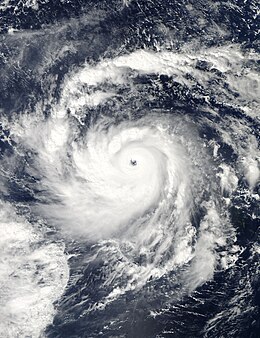 Typhoon Nida near peak intensity on November 25 | |
| Formed | November 21, 2009 |
| Dissipated | December 3, 2009 |
| Highest winds | 10-minute sustained: 215 km/h (130 mph) 1-minute sustained: 285 km/h (180 mph) |
| Lowest pressure | 905 hPa (mbar); 26.72 inHg |
| Fatalities | None |
| Damage | None |
| Areas affected | Micronesia, Guam |
| Part of the 2009 Pacific typhoon season | |
Typhoon Nida, known in the Philippines as Typhoon Vinta, was the most intense tropical cyclone in the Northwest Pacific Ocean during the 2000s, tied with Jangmi in 2008.[1] It was also the most intense tropical cyclone worldwide in 2009.
Meteorological history[]

Tropical storm (39–73 mph, 63–118 km/h)
Category 1 (74–95 mph, 119–153 km/h)
Category 2 (96–110 mph, 154–177 km/h)
Category 3 (111–129 mph, 178–208 km/h)
Category 4 (130–156 mph, 209–251 km/h)
Category 5 (≥157 mph, ≥252 km/h)
Unknown
Early on November 21 the Joint Typhoon Warning Center (JTWC) reported that an area of convection had persisted within a monsoon trough about 880 km, (545 mi) to the southeast of Guam island.[2][3] At this time the system was moving around the subtropical ridge of pressure, with an anticyclone over the cyclone helping the convection to consolidate over a broad and elongated low level circulation center which was located in an area of minimal vertical wind shear.[2][3] Later that morning a Tropical Cyclone Formation Alert was released as deep convection increased in organization with multiple bands of convection starting to wrap into the developing low level circulation center. The system was then declared as a tropical depression by the JMA later that day before the JTWC followed suit early the next day, who assigned the designation of 26W to the depression.[4][5] During November 22, the depression remained weak, before during the next day both the JMA and the JTWC upgraded the depression to a tropical storm, with the JMA assigning the international number of 0922 and name of Nida as it started to move along a subtropical ridge.[6][7][8]

Later on November 23, microwave imagery showed that an eye had developed within a well defined low level circulation center.[9] Early the next day, the JTWC reported that Nida had intensified into a category 1 typhoon as the eye became well defined with deep convection wrapping around most of the eye.[10][11] However, despite the JTWC reporting 1-minute sustained wind speeds of 160 km/h, (100 mph), the JMA only reported 10-minute sustained wind speeds of 110 km/h, (70 mph) which made Nida a Severe Tropical Storm.[12][13] Early on November 25 the JMA reported that Nida had intensified into a typhoon before reporting later that day that the typhoon had rapidly intensified under favourable conditions and reached its peak 10-minute wind speeds of 195 km/h (120 mph), with a peak pressure of 905 hPa.[14][15] During the next day the JTWC also reported that Typhoon Nida had rapidly intensified over the previous 18 hours into a category five super typhoon with winds of 285 km/h (180 mph), as it maintained a well defined symmetrical structure. The JTWC then reported that Nida had intensified a little bit more and reached its peak 1-minute sustained wind speeds of 290 km/h (185 mph).[12]
The typhoon later weakened to a category four, before re-strengthening to a category five on November 27, remaining quasi-stationary for more than two days. It weakened to a tropical depression on December 2 due to stronger vertical wind shear associated by the Northeast monsoon, and the storm dissipated on December 4.[12]
Preparations and impact[]
Micronesia[]
Early on November 24, the National Weather Service Weather Forecast Office in Tiyan, Guam (NWS Guam) placed the island of Faraulep under a tropical storm warning, before later that morning issuing tropical storm watches for Fais and Ulithi.[16][17] As Nida was upgraded to a typhoon by the JTWC, the NWS upgraded the tropical storm warning for Faraulep to a typhoon warning.[18] Later that day they reported that the typhoon warning for Faraulep had been cancelled as Nida was moving to the northwest away from Faraulep before early the next day the tropical storm warning for Fais and Ulithi were cancelled.[19]
See also[]
- Typhoon Mitag (2002)
- Typhoon Jangmi (2008)
- Typhoon Lekima (2013)
- Typhoon Halong (2019)
References[]
- ^ "Typhoon List". Japan Meteorological Agency. Retrieved June 10, 2013.
- ^ a b "Significant tropical weather advisory for the Western and South Pacific Ocean 2009-11-21 06z". Joint Typhoon Warning Center. November 21, 2009. Retrieved November 22, 2009.[permanent dead link]
- ^ a b "Tropical Cyclone Formation Alert 2009-11-21 1100z". Joint Typhoon Warning Center. November 21, 2009. Retrieved November 22, 2009.[permanent dead link]
- ^ "JMA WWJP25 Advisory 2009-11-21 18z". Japan Meteorological Agency. November 21, 2009. Retrieved November 22, 2009.[permanent dead link]
- ^ "Prognostic reasoning for Tropical Depression 26W". Joint Typhoon Warning Center. November 22, 2009. Retrieved November 22, 2009.[permanent dead link]
- ^ "JTWC Tropical Cyclone Advisory 2009-11-23 09z". Joint Typhoon Warning Center. November 23, 2009. Retrieved November 28, 2009.[permanent dead link]
- ^ "JMA Tropical Cyclone Advisory 2009-11-23 12z". Japan Meteorological Agency. November 23, 2009. Retrieved November 28, 2009.
{{cite web}}: Check|archive-url=value (help)CS1 maint: url-status (link) - ^ "Prognostic reasoning for Tropical Storm 26W (Nida)". Joint Typhoon Warning Center. November 23, 2009. Retrieved November 23, 2009.
- ^ "JTWC Tropical Cyclone Warning 2009-11-23 21z". Joint Typhoon Warning Center. November 23, 2009. Retrieved November 29, 2009.
- ^ "JTWC Tropical Cyclone Advisory 2009-11-24 09z". Joint Typhoon Warning Center. November 24, 2009. Retrieved November 29, 2009.[permanent dead link]
- ^ "Prognastic Reasoning for Typhoon 26W (Nida) 2009-11-24 15z". Joint Typhoon Warning Center. November 24, 2009. Retrieved November 29, 2009.
- ^ a b c "Super Typhoon 26W (Nida) JTWC Running Best Track". Joint Typhoon Warning Center. United States Naval Research Laboratory. November 20, 2009. Retrieved November 29, 2009.
- ^ "JMA Tropical Cyclone Advisory 2009-11-24 21z". Japan Meteorological Agency. November 24, 2009. Retrieved November 29, 2009.
{{cite web}}: Check|archive-url=value (help)CS1 maint: url-status (link) - ^ "JMA Tropical Cyclone Advisory 2009-11-25 00z". Japan Meteorological Agency. November 25, 2009. Retrieved November 29, 2009.
{{cite web}}: Check|archive-url=value (help)CS1 maint: url-status (link) - ^ "JMA Tropical Cyclone Advisory 2009-11-25 12z". Japan Meteorological Agency. November 25, 2009. Retrieved November 29, 2009.
{{cite web}}: Check|archive-url=value (help)CS1 maint: url-status (link) - ^ Dan Mundell (November 24, 2009). "Tropical Storm 26W (Nida) Special Advisory Number Eight A". National Weather Service in Tiyan, Guam. Archived from the original on November 27, 2009. Retrieved November 24, 2009.
- ^ Dan Mundell (November 24, 2009). "Tropical Storm 26W (Nida) Advisory Number Nine". National Weather Service in Tiyan, Guam. Archived from the original on November 24, 2009. Retrieved November 24, 2009.
{{cite web}}: CS1 maint: unfit URL (link) - ^ Paul Stanko and Clint Simpson (November 24, 2009). "Tropical Storm 26W (Nida) Special Advisory Number Ten A". National Weather Service in Tiyan, Guam. Archived from the original on November 28, 2009. Retrieved November 24, 2009.
- ^ Dan Mundell (November 25, 2009). "Tropical Storm 26W (Nida) Advisory Number Thirteen". National Weather Service in Tiyan, Guam. Archived from the original on November 25, 2009. Retrieved November 25, 2009.
{{cite web}}: CS1 maint: unfit URL (link)
External links[]
| Wikimedia Commons has media related to Typhoon Nida (2009). |
- RSMC Tokyo – Typhoon Center
- Best Track Data of Typhoon Nida (0922) (in Japanese)
- Best Track Data (Graphics) of Typhoon Nida (0922)
- Best Track Data (Text)
- JTWC Best Track Data of Super Typhoon 26W (Nida)
- 26W.NIDA from the U.S. Naval Research Laboratory
- General information of Typhoon Nida (0922) from Digital Typhoon
Tropical cyclones of the 2009 Pacific typhoon season | ||||||||||||||||||||||||||||||||||||||||||||||||||||||||||||||||||||||||||||||||||||
|---|---|---|---|---|---|---|---|---|---|---|---|---|---|---|---|---|---|---|---|---|---|---|---|---|---|---|---|---|---|---|---|---|---|---|---|---|---|---|---|---|---|---|---|---|---|---|---|---|---|---|---|---|---|---|---|---|---|---|---|---|---|---|---|---|---|---|---|---|---|---|---|---|---|---|---|---|---|---|---|---|---|---|---|---|
 |
| |||||||||||||||||||||||||||||||||||||||||||||||||||||||||||||||||||||||||||||||||||
| ||||||||||||||||||||||||||||||||||||||||||||||||||||||||||||||||||||||||||||||||||||
- 2009 Pacific typhoon season
- Typhoons
- Tropical cyclones in 2009