Tysvær
Tysvær kommune | |
|---|---|
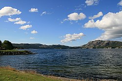 View of the lake Aksdalsvatnet | |
 Rogaland within Norway | |
 Tysvær within Rogaland | |
| Coordinates: 59°21′42″N 05°32′34″E / 59.36167°N 5.54278°ECoordinates: 59°21′42″N 05°32′34″E / 59.36167°N 5.54278°E | |
| Country | Norway |
| County | Rogaland |
| District | Haugaland |
| Established | 1849 |
| Administrative centre | Aksdal |
| Government | |
| • Mayor (2015) | Sigmund Lier (Ap) |
| Area | |
| • Total | 425.48 km2 (164.28 sq mi) |
| • Land | 399.85 km2 (154.38 sq mi) |
| • Water | 25.63 km2 (9.90 sq mi) 6% |
| Area rank | 231 in Norway |
| Population (2020) | |
| • Total | 11,065 |
| • Rank | 103 in Norway |
| • Density | 27.7/km2 (72/sq mi) |
| • Change (10 years) | 11.5% |
| Demonym(s) | Tysværbu[1] |
| Time zone | UTC+01:00 (CET) |
| • Summer (DST) | UTC+02:00 (CEST) |
| ISO 3166 code | NO-1146 |
| Official language form | Nynorsk[2] |
| Website | tysver |


Tysvær is a municipality in Rogaland county, Norway. It is part of the Haugalandet region. The municipality is located on the Haugalandet peninsula on the northern side of the Boknafjorden, just east of the towns of Kopervik and Haugesund. The administrative centre of the municipality is the village of Aksdal. Other villages in the municipality include Dueland, Førre, Grinde, Hervik, Hindaråvåg, Nedstrand, Skjoldastraumen, Susort, Tysvær, and Yrke.
The European route E39 highway and European route E134 highways traverse the municipality with their junction located at Aksdal in Tysvær. The on the E39 highway connects the mainland of Tysvær to the island municipality of Bokn to the south. The Karmøy Tunnel connects Tysvær to the town of Kopervik in neighboring Karmøy municipality.
The 425-square-kilometre (164 sq mi) municipality is the 231st largest by area out of the 356 municipalities in Norway. Tysvær is the 103rd most populous municipality in Norway with a population of 11,065. The municipality's population density is 27.7 inhabitants per square kilometre (72/sq mi) and its population has increased by 11.5% over the previous 10-year period.[3][4]
General information[]

The municipality of Tysvær was established in 1849 when it was separated from the large municipality of Skjold. Initially, the municipality had a population of 2,058. During the 1960s, there were many municipal mergers across Norway due to the work of the Schei Committee. On 1 January 1965, the following areas were merged into a newly enlarged municipality of Tysvær:
- the old municipality of Tysvær (population: 1,862)
- the municipality of Nedstrand (population: 1,200)
- the Gismarvik, Førre, and Stegaberg areas of Avaldsnes municipality (population: 994)
- the Grinde, Dueland, and Yrkje areas of Skjold municipality (population: 1,133)
- the Breidal and Stølsvik farms from Vats municipality (population: 16)
- the Hapnes and Dokskar farms from Vikedal municipality (population: 2)
On 1 January 1969, the small Sponevik farm area (population: 6), just north of the village of Skjoldastraumen, was transferred from the neighboring Vindafjord municipality to Tysvær.[5]
Name[]
The municipality (originally the parish) is named after the old Tysvær farm (Old Norse: Teitsfjörðr), since the first Tysvær Church was built there. The first element is the genitive case of the old male name Teitr and the last element is fjörðr which means "fjord".[6]
Coat of arms[]
The coat of arms was granted on 3 February 1984. The arms show a silver heron on a blue background. The heron was chosen as a symbol for the municipality since there are several large colonies of grey herons in the municipality.[7]
Churches[]

The Church of Norway has three parishes (sokn) within the municipality of Tysvær. It is part of the Haugaland prosti (deanery) in the Diocese of Stavanger.
| Parish (sokn) | Church name | Location of the church | Year built |
|---|---|---|---|
| Førresfjorden | Aksdal Church | Aksdal | 1995 |
| Førre Church | Førre | 1893 | |
| Nedstrand | Nedstrand Church | Hindaråvåg | 1868 |
| Skjoldastraumen Church | Skjoldastraumen | 1910 | |
| Tysvær | Tysvær Church | Tysværvåg | 1852 |

Geography[]
The municipality lies on the northern shore of the Boknafjorden, with the Skjoldafjorden and Vindafjorden both partially located within the municipality. The island of Borgøy lies in the middle of the Skjoldafjorden in Tysvær.
The lake Aksdalsvatnet is the largest lake in the municipality. Another notable lake is Stakkastadvatnet, which lies on the Haugesund-Tysvær municipal border.
Tysvær has a number of scenic walks including Heggelifjellet and Kvinnesland, the source of the name Kvindesland.[citation needed]
Economy[]

The Kårstø industrial site is located along the shores of the Boknafjorden in southwestern Tysvær. The site has many natural gas-related facilities including the Kårstø Power Station.
Government[]
All municipalities in Norway, including Tysvær, are responsible for primary education (through 10th grade), outpatient health services, senior citizen services, unemployment and other social services, zoning, economic development, and municipal roads. The municipality is governed by a municipal council of elected representatives, which in turn elect a mayor.[8] The municipality falls under the Haugaland District Court and the Gulating Court of Appeal.
Municipal council[]
The municipal council (Kommunestyre) of Tysvær is made up of 29 representatives that are elected to four year terms. Currently, the party breakdown is as follows:
| Party Name (in Nynorsk) | Number of representatives | |
|---|---|---|
| Labour Party (Arbeidarpartiet) | 9 | |
| Progress Party (Framstegspartiet) | 3 | |
| Conservative Party (Høgre) | 6 | |
| Christian Democratic Party (Kristeleg Folkeparti) | 3 | |
| Centre Party (Senterpartiet) | 6 | |
| Socialist Left Party (Sosialistisk Venstreparti) | 1 | |
| Liberal Party (Venstre) | 1 | |
| Total number of members: | 29 | |
Notable residents[]
- Cleng Peerson (1783 near Tysvær – 1865) leader of the first group of Norwegians to emigrate to the United States
- Anders Andersen Bjelland (1790 in Nedstrand – 1850) farmer & politician.
- Asbjørn Kloster (1823 in Vestre Bokn – 1876) a social reformer and leader of the Norwegian temperance movement
- Lars Hertervig (1830 at Borgøy – 1902) a painter of semi-fantastical works of coastal landscapes
- John S. Tveit (born 1931 in Tysvær) a politician and Mayor of Tysvær, 1967 to 1971
- Nils Olav Fjeldheim (born 1977 in Tysværvåg) sprint and marathon canoeist, bronze medallist, 2004 Summer Olympics
- Peder Losnegård (born 1992 in Tysvær) stage name Lido, a hip hop artist, rapper, producer and songwriter
References[]
- ^ "Navn på steder og personer: Innbyggjarnamn" (in Norwegian). Språkrådet.
- ^ "Forskrift om målvedtak i kommunar og fylkeskommunar" (in Norwegian). Lovdata.no.
- ^ Statistisk sentralbyrå (2020). "Table: 06913: Population 1 January and population changes during the calendar year (M)" (in Norwegian).
- ^ Statistisk sentralbyrå (2020). "09280: Area of land and fresh water (km²) (M)" (in Norwegian).
- ^ Jukvam, Dag (1999). "Historisk oversikt over endringer i kommune- og fylkesinndelingen" (PDF) (in Norwegian). Statistisk sentralbyrå.
- ^ Rygh, Oluf (1915). Norske gaardnavne: Stavanger amt (in Norwegian) (10 ed.). Kristiania, Norge: W. C. Fabritius & sønners bogtrikkeri. p. 421.
- ^ "Civic heraldry of Norway - Norske Kommunevåpen". Heraldry of the World. Retrieved 24 September 2015.
- ^ Hansen, Tore, ed. (12 May 2016). "kommunestyre". Store norske leksikon (in Norwegian). Kunnskapsforlaget. Retrieved 28 June 2020.
- ^ "Tall for Norge: Kommunestyrevalg 2019 - Rogaland". Valg Direktoratet. Retrieved 2 July 2020.
- ^ Jump up to: a b c d "Table: 04813: Members of the local councils, by party/electoral list at the Municipal Council election (M)" (in Norwegian). Statistics Norway.
- ^ "Tall for Norge: Kommunestyrevalg 2011 - Rogaland". Valg Direktoratet. Retrieved 2 July 2020.
- ^ "Kommunestyrevalget 1995" (PDF) (in Norwegian). Oslo-Kongsvinger: Statistisk sentralbyrå. 1996. Retrieved 2 July 2020.
- ^ "Kommunestyrevalget 1991" (PDF) (in Norwegian). Oslo-Kongsvinger: Statistisk sentralbyrå. 1993. Retrieved 2 July 2020.
- ^ "Kommunestyrevalget 1987" (PDF) (in Norwegian). Oslo-Kongsvinger: Statistisk sentralbyrå. 1988. Retrieved 2 July 2020.
- ^ "Kommunestyrevalget 1983" (PDF) (in Norwegian). Oslo-Kongsvinger: Statistisk sentralbyrå. 1984. Retrieved 2 July 2020.
- ^ "Kommunestyrevalget 1979" (PDF) (in Norwegian). Oslo: Statistisk sentralbyrå. 1979. Retrieved 2 July 2020.
- ^ "Kommunevalgene 1975" (PDF) (in Norwegian). Oslo: Statistisk sentralbyrå. 1977. Retrieved 2 July 2020.
- ^ "Kommunevalgene 1972" (PDF) (in Norwegian). Oslo: Statistisk sentralbyrå. 1973. Retrieved 2 July 2020.
- ^ "Kommunevalgene 1967" (PDF) (in Norwegian). Oslo: Statistisk sentralbyrå. 1967. Retrieved 2 July 2020.
- ^ "Kommunevalgene 1963" (PDF) (in Norwegian). Oslo: Statistisk sentralbyrå. 1964. Retrieved 2 July 2020.
- ^ "Kommunevalgene og Ordførervalgene 1959" (PDF) (in Norwegian). Oslo: Statistisk sentralbyrå. 1960. Retrieved 2 July 2020.
- ^ "Kommunevalgene og Ordførervalgene 1955" (PDF) (in Norwegian). Oslo: Statistisk sentralbyrå. 1957. Retrieved 2 July 2020.
- ^ "Kommunevalgene og Ordførervalgene 1951" (PDF) (in Norwegian). Oslo: Statistisk sentralbyrå. 1952. Retrieved 2 July 2020.
- ^ "Kommunevalgene og Ordførervalgene 1947" (PDF) (in Norwegian). Oslo: Statistisk sentralbyrå. 1948. Retrieved 2 July 2020.
- ^ "Kommunevalgene og Ordførervalgene 1945" (PDF) (in Norwegian). Oslo: Statistisk sentralbyrå. 1947. Retrieved 2 July 2020.
- ^ "Kommunevalgene og Ordførervalgene 1937" (PDF) (in Norwegian). Oslo: Statistisk sentralbyrå. 1938. Retrieved 2 July 2020.
External links[]
 Media related to Tysvær at Wikimedia Commons
 The dictionary definition of Tysvær at Wiktionary
 Rogaland travel guide from Wikivoyage
- Municipal fact sheet from Statistics Norway (in Norwegian)
| hide | |||||||
|---|---|---|---|---|---|---|---|
| |||||||
 | Towns and cities |
|  | ||||
| Municipalities | |||||||
| show Authority control |
|---|
- Tysvær
- Municipalities of Rogaland
- 1849 establishments in Norway