U3 (Berlin U-Bahn)
This article needs additional citations for verification. (January 2019) |
show This article may be expanded with text translated from the corresponding article in German. (December 2012) Click [show] for important translation instructions. |
| U3 | |
|---|---|
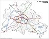
 Map of Berlin's underground line U3 | |
| Overview | |
| Stations | 24 |
| Service | |
| Type | Rapid transit |
| System | Berlin U-Bahn |
| Operator(s) | Berliner Verkehrsbetriebe |
| History | |
| Line opened | 12 October 1913 |
| U3 designation | 12 December 2004 |
| Technical | |
| Line length | 12.1 km (7.5 mi) |
| Track gauge | 1,435 mm (4 ft 8+1⁄2 in) standard gauge |
| Profile | Kleinprofil |
| Electrification | 750 V DC third rail |
U3 is a line on the Berlin U-Bahn created in its current version on 7 May 2018.
The routing is largely the same as the previous U2 until 1993, but it runs from Krumme Lanke to Wittenbergplatz. The route was renumbered to U1 from 1993 to 2004. It was extended one station further east to Nollendorfplatz to enable trains to be reversed and to allow one-stop transfer to the U4 in 2003. On 7 May 2018, the U3 was extended to run with the U1 all the way to Warschauer Straße.
Routing[]
The line to the Krumme Lanke station has changed several times in the course of its existence. Initially, line A connected Krumme Lanke in the southwest of Berlin with Pankow in the north and was marked in red on the network plans. From 1957 two lines served the southwestern route section: the red route AII to Pankow as before, and a green route BII to the Warschauer Brücke. After the construction of the Berlin Wall in 1961, the small profile network was completely redesigned in 1966. The route to Dahlem received the line designation 2, leading initially to Gleisdreieck over Bülowstraße, and from 1972 only to Wittenbergplatz. The 3 line - with a dark green color code - was assigned to the stub track Uhlandstraße - Wittenbergplatz. This changed again in 1993 as the route was marked green again and received the line number U1, which led to Warschauer Straße. The designation U3 for the route to Uhlandstraße, however, fell away, as this now served a line U15, also to Warschauer Straße. Finally, the line was redesignated with the network timetable change in December 2004 to the turquoise U3. Since 2005, the line also operates in night traffic. From 4 to 7 March 2013, the trains, due to construction work on the section between Uhlandstraße and Kurfürstendamm conditionally, were designated again as U1 between Krumme Lanke and Warschauer Straße. Unlike in analogous cases (U12), no corresponding line designation (U13) was introduced here.
Extension[]
In the south, there are plans to extend the U3 towards the Berlin Mexikoplatz station, running via Lindenthaler Allee, Düppel, Kleinmachnow Nord, Hakenheide, Förster-Funke-Allee and towards Machnower Schleuse. Even though this would only take 700 meters of new tracks, the budgetary constraints of the Berlin Senate hinders completion.
2018 extension[]
As of 7 May 2018, the U3 was extended from Nollendorfplatz to Warschauer Straße during the day. The line runs throughout the day on the entire line every 5 minutes from Monday to Friday. Early in the morning and in the late evening and on Saturdays/Sundays the train will run every ten minutes. Due to lower demand, during nights and early mornings (weekdays until 06:00 and weekends until 10:00), the line terminates at Nollendorfplatz.[1]
Frequency[]
Train frequencies were running at 5 minutes on weekdays, 10 minutes on weekends and since 2006, a 15-minute night service was offered on weekends, and "N3" was offered during weekday nights.
Former U3[]
| Linie CBTC Driverless Line | ||||||||||||||||||||||||||||||||||||||||||||||||||||||||||||||||||||||||||||||||||||||||||||||||||||||||||||||||||||||||||||||||||||||||||||||||||||||||||||||||||||||||||||||||||||||||||||||||||||||||||||||||
|---|---|---|---|---|---|---|---|---|---|---|---|---|---|---|---|---|---|---|---|---|---|---|---|---|---|---|---|---|---|---|---|---|---|---|---|---|---|---|---|---|---|---|---|---|---|---|---|---|---|---|---|---|---|---|---|---|---|---|---|---|---|---|---|---|---|---|---|---|---|---|---|---|---|---|---|---|---|---|---|---|---|---|---|---|---|---|---|---|---|---|---|---|---|---|---|---|---|---|---|---|---|---|---|---|---|---|---|---|---|---|---|---|---|---|---|---|---|---|---|---|---|---|---|---|---|---|---|---|---|---|---|---|---|---|---|---|---|---|---|---|---|---|---|---|---|---|---|---|---|---|---|---|---|---|---|---|---|---|---|---|---|---|---|---|---|---|---|---|---|---|---|---|---|---|---|---|---|---|---|---|---|---|---|---|---|---|---|---|---|---|---|---|---|---|---|---|---|---|---|---|---|---|---|---|---|---|---|---|
 | ||||||||||||||||||||||||||||||||||||||||||||||||||||||||||||||||||||||||||||||||||||||||||||||||||||||||||||||||||||||||||||||||||||||||||||||||||||||||||||||||||||||||||||||||||||||||||||||||||||||||||||||||
| Technical | ||||||||||||||||||||||||||||||||||||||||||||||||||||||||||||||||||||||||||||||||||||||||||||||||||||||||||||||||||||||||||||||||||||||||||||||||||||||||||||||||||||||||||||||||||||||||||||||||||||||||||||||||
| Line length | 31.8 km (19.8 mi) | |||||||||||||||||||||||||||||||||||||||||||||||||||||||||||||||||||||||||||||||||||||||||||||||||||||||||||||||||||||||||||||||||||||||||||||||||||||||||||||||||||||||||||||||||||||||||||||||||||||||||||||||
| Track gauge | 1,435 mm (4 ft 8+1⁄2 in) | |||||||||||||||||||||||||||||||||||||||||||||||||||||||||||||||||||||||||||||||||||||||||||||||||||||||||||||||||||||||||||||||||||||||||||||||||||||||||||||||||||||||||||||||||||||||||||||||||||||||||||||||
| ||||||||||||||||||||||||||||||||||||||||||||||||||||||||||||||||||||||||||||||||||||||||||||||||||||||||||||||||||||||||||||||||||||||||||||||||||||||||||||||||||||||||||||||||||||||||||||||||||||||||||||||||
Until 1993 U3 referred to the section of line between Wittenbergplatz and Uhlandstraße, it was formerly numbered BII (until 1957), BIV (from 1957 to 1966) and Line 3 (from 1966 to 1984), before being renamed U3. In 1993, this section was renumbered to U15 and became a branch of the U1.
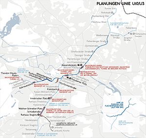
With the change of train numbers in December 2004, there were some confusion as the planned final phase of the U3 line from Theodor-Heuss-Platz via Westkreuz, Adenauerplatz, Kurfürstendamm, Wittenbergplatz, Lutzowplatz, Potsdamer Platz, and Leipziger Straße to Alexanderplatz, and from there on to Weißensee and Karow-Ost, would overlap with the present course of the U3, as the provisional name would be with driverless Alstom Metropolis trains to be purchased for the U3. However, these plans were scrapped.
References[]
- ^ "Hoch drei". bvg.de. 7 March 2018. Retrieved 9 March 2018.
External links[]
 Media related to U3 (Berlin U-Bahn) at Wikimedia Commons
- Berlin U-Bahn lines
- Railway lines opened in 1913
- 1913 establishments in Germany