Upper Hardres
| Upper Hardres | |
|---|---|
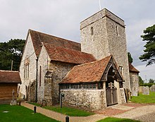 The medieval Church of St Peter and St Paul in Upper Hardres | |
 Upper Hardres Location within Kent | |
| Area | 8.11 km2 (3.13 sq mi) |
| Population | 385 (Civil Parish 2011)[1] |
| • Density | 47/km2 (120/sq mi) |
| OS grid reference | TR152507 |
| Civil parish |
|
| District | |
| Shire county | |
| Region | |
| Country | England |
| Sovereign state | United Kingdom |
| Post town | CANTERBURY |
| Postcode district | CT4 |
| Dialling code | 01227 |
| Police | Kent |
| Fire | Kent |
| Ambulance | South East Coast |
| UK Parliament | |

Upper Hardres /hɑːrdz/ is a village and civil parish in the City of Canterbury, in the district of Kent, England.
The name of the Hardres family is perpetuated in the twin villages of Upper Hardres and Lower Hardres (pronounced 'hards'), on the Roman road, Stone Street, south-west of the city of Canterbury. The family owned the area for 700 years after the Norman Conquest. It is said that Thomas Hardres, who was knighted for his valor at the Siege of Boulogne in 1544, brought back the town gates and erected them at Upper Hardres, though there is little evidence of their existence today.[2]
References[]
- ^ Key Statistics; Quick Statistics: Population Density United Kingdom Census 2011 Office for National Statistics Retrieved 21 November 2013
- ^ Canterbury City Council
External links[]
![]() Media related to Upper Hardres at Wikimedia Commons
Media related to Upper Hardres at Wikimedia Commons

This Kent location article is a stub. You can help Wikipedia by . |
Categories:
- Villages in Kent
- City of Canterbury
- Civil parishes in Kent
- Kent geography stubs