Ickham and Well
(Redirected from )
| Ickham and Well | |
|---|---|
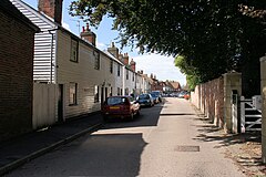 The Street, Ickham | |
 Ickham and Well Location within Kent | |
| Area | 9.3 km2 (3.6 sq mi) |
| Population | 437 (Civil Parish 2011)[1] |
| • Density | 47/km2 (120/sq mi) |
| OS grid reference | TR221581 |
| Civil parish |
|
| District | |
| Shire county | |
| Region | |
| Country | England |
| Sovereign state | United Kingdom |
| Post town | CANTERBURY |
| Postcode district | CT3 |
| Dialling code | 01227 |
| Police | Kent |
| Fire | Kent |
| Ambulance | South East Coast |
| UK Parliament | |

Ickham and Well is a mostly rural civil parish east of Canterbury in Kent, South East England.
The parish covers the villages of Ickham and Bramling just off the A257 Sandwich Road. It has several listed buildings in architecture of old, well-preserved houses, with the 13th-century parish church of St John the Evangelist in the midst. A recent archaeological excavation at Ickham has revealed evidence of Roman metalwork and copper brooches.[2]
Geography[]
Ickham centres on a single road.
The Rivers Little Stour and Wingham flow through the parish before joining with the Great Stour to become the River Stour.

Ickham Village hall
Notable people[]
- J. G. Robertson (1859–1940), British singer and actor died in Ickham.
References[]
- ^ Key Statistics; Quick Statistics: Population Density United Kingdom Census 2011 Office for National Statistics Retrieved 21 November 2013
- ^ Canterbury City Council
External links[]
 Media related to Ickham and Well at Wikimedia Commons

Kent Portal | |
| Unitary authorities | |
| Boroughs or districts | |
| Major settlements |
|
| Rivers | See: Rivers of Kent |
| Topics |
|
Categories:
- Civil parishes in Kent
- City of Canterbury