Upper Manhattan
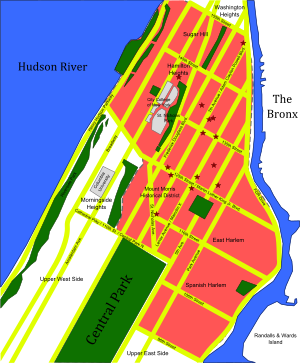

Upper Manhattan is the most northern region of the New York City borough of Manhattan. Its southern boundary has been variously defined, but some of the most common usages are 96th Street, the northern boundary of Central Park (110th Street), 125th Street or 155th Street.[citation needed]
Upper Manhattan is generally taken to include the neighborhoods of Marble Hill, Inwood, Washington Heights (including Fort George, Sherman Creek and Hudson Heights), Harlem (including Sugar Hill, Hamilton Heights and Manhattanville), East Harlem and parts of the Upper West Side (Morningside Heights and Manhattan Valley).
The George Washington Bridge connects Washington Heights in Upper Manhattan across the Hudson River to Fort Lee, New Jersey, and is the world's busiest motor vehicle bridge.[1][2]
In the late 19th century, the IRT Ninth Avenue Line and other elevated railroads brought people to the previously rustic Upper Manhattan. Until the late 20th century it was less influenced by the gentrification that had taken place in other parts of New York over the previous 30 years.
Tourist attractions[]
Like other residential areas, Upper Manhattan is not a major center of tourism in New York City, although some tourist attractions lie within it, such as Grant's Tomb, the Apollo Theater, and The Cloisters, Sylvia's Restaurant, the Hamilton Grange, the Morris–Jumel Mansion, Minton's Playhouse, Sugar Hill, Riverside Church, the National Jazz Museum in Harlem and the Dyckman House, along with Fort Tryon Park, most of Riverside Park, Riverbank State Park, Sakura Park, and other parks.
Gallery[]

The Cloisters in Fort Tryon Park houses the medieval art collection of the Metropolitan Museum of Art

The Little Red Lighthouse under the George Washington Bridge

Inwood Hill Park contains the last remnant of the primeval forest which once covered Manhattan; these caves were used by native Lenape people


See also[]
References[]
- ^ "Port Authority of New York and New Jersey - George Washington Bridge". The Port Authority of New York and New Jersey. Retrieved September 13, 2013.
- ^ Woodruff, Bob; Zak, Lana & Wash, Stephanie (November 20, 2012). "GW Bridge Painters: Dangerous Job on Top of the World's Busiest Bridge". ABC News. Retrieved June 6, 2016.
External links[]


Coordinates: 40°47′49″N 73°56′56″W / 40.797°N 73.949°W

| Authority control |
|
|---|
- Upper Manhattan
- Neighborhoods in Manhattan