Alphabet City, Manhattan
Alphabet City | |
|---|---|
Neighborhood of Manhattan | |
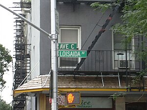 Avenue C was designated Loisaida Avenue in recognition of the neighborhood's Puerto Rican heritage. | |
 Location in New York City | |
| Coordinates: 40°43′34″N 73°58′44″W / 40.726°N 73.979°WCoordinates: 40°43′34″N 73°58′44″W / 40.726°N 73.979°W | |
| Country | |
| State | |
| City | New York City |
| Borough | Manhattan |
| Community District | Manhattan 3[1] |
| Area | |
| • Total | 1.99 km2 (0.768 sq mi) |
| Population (2016)[2] | |
| • Total | 63,347 |
| • Density | 32,000/km2 (82,000/sq mi) |
| Ethnicity | |
| • White | 73.5% |
| • Black | 3.2% |
| • Hispanic | 12.9% |
| • Asian | 7.3% |
| • Other | 2.7% |
| Economics | |
| • Median income | $74,265 |
| ZIP Codes | 10009 |
| Area codes | 212, 332, 646, and 917 |

| Part of a series on |
| Ethnicity in New York City |
|---|
Alphabet City is a neighborhood located within the East Village in the New York City borough of Manhattan. Its name comes from Avenues A, B, C, and D, the only avenues in Manhattan to have single-letter names. It is bordered by Houston Street to the south and by 14th Street to the north, along the traditional northern border of the East Village and south of Stuyvesant Town and Peter Cooper Village.[3][4][5] Some famous landmarks include Tompkins Square Park and the Nuyorican Poets Cafe.
The neighborhood has a long history, serving as a cultural center and ethnic enclave for Manhattan's German, Polish, Hispanic, and Jewish populations. However, there is much dispute over the borders of the Lower East Side, Alphabet City, and East Village. Historically, Manhattan's Lower East Side was 14th Street at the northern end, bound on the east by East River and on the west by First Avenue; today, that same area is Alphabet City. The area's German presence in the early 20th century, in decline, virtually ended after the General Slocum disaster in 1904.
Alphabet City is part of Manhattan Community District 3 and its primary ZIP Code is 10009.[1] It is patrolled by the 9th Precinct of the New York City Police Department.
Etymology[]

The original layout of Manhattan streets specified by the Commissioners' Plan of 1811 designated 16 north-south streets specified as 100 feet (30 m) in width, including 12 numbered avenues and four designated by letter located east of First Avenue called Avenue A, Avenue B, etc.[6] In Midtown and north, Avenue A was eventually renamed as Beekman Place, Sutton Place, York Avenue and Pleasant Avenue; Avenue B was renamed East End Avenue, though Paladino Avenue in East Harlem is sometimes called Avenue B. (There were no avenues farther east in this part of the city.) Farther south, the avenues retained their letter designations.
The name "Alphabet City" is thought to be relatively new, as the East Village and Alphabet City was considered to be simply a part of the Lower East Side for much of its history. Urban historian Peter G. Rowe posits that the name entered use in the 1980s, when gentrification spread east from the Village.[7] The term's first appearance in The New York Times is in a 1984 editorial penned by then mayor Ed Koch, appealing to the federal government to aid in fighting crime on the neighborhood's beleaguered streets:
The neighborhood, known as Alphabet City because of its lettered avenues that run easterly from First Avenue to the river, has for years been occupied by a stubbornly persistent plague of street dealers in narcotics whose flagrantly open drug dealing has destroyed the community life of the neighborhood.[8]
A later 1984 Times article describes it using a number of names: "Younger artists ... are moving downtown to an area variously referred to as Alphabetland, Alphabetville, or Alphabet City (Avenues A, B, C and so forth on the Lower East Side of Manhattan)".[9]
Several local nickname sets associated with the ABCD denotation have included Adventurous, Brave, Crazy and Dead and, more recently by writer George Pendle, "Affluent, Bourgeois, Comfortable, Decent".[10]
History[]
Early development[]
The area that is today known as Alphabet City was originally occupied by the Lenape Native Americans.[11] The Lenape moved between different seasons, moving toward the shore to fish during the summers, and moving inland to hunt and grow crops during the fall and winter.[12] Manhattan was purchased in 1626 by Peter Minuit of the Dutch West India Company, who served as director-general of New Netherland.[13][14] The population of the Dutch colony of New Amsterdam was located primarily below the current Fulton Street, while north of it were a number of small plantations and large farms that were then called bouwerij (anglicized to "boweries"; modern Dutch: boerderij). Around these farms were a number of enclaves of free or "half-free" Africans, which served as a buffer between the Dutch and the Native Americans.[11][15] There were several "boweries" within what is now Alphabet City. The largest was Bowery no. 2, which passed through several inhabitants, before the eastern half of the land was subdivided and given to Harmen Smeeman in 1647.[16][17]
Many of these farms had become wealthy country estates by the middle of the 18th century. The Stuyvesant, DeLancey, and Rutgers families would come to own most of the land in the Lower East Side, including the portions that would later become Alphabet City.[18] By the late 18th century, Lower Manhattan estate owners started having their lands surveyed in order to facilitate the future growth of Lower Manhattan into a street grid system.[16][17] Because each landowner had done their own survey, there were multiple different street grids that did not align with each other. Various state laws, passed in the 1790s, gave the city of New York the ability to plan out, open, and close streets.[19][20] The final plan, published in 1811, resulted in the current street grid north of Houston Street.[21] The north-south avenues within the Lower East Side were finished in the 1810s, followed by the west-east streets in the 1820s.[22]
19th century[]

The Commissioners' Plan and resulting street grid was the catalyst for the northward expansion of the city,[23] and for a short period, the portion of the Lower East Side that is now Alphabet City was one of the wealthiest residential neighborhoods in the city.[24] Following the grading of the streets, development of rowhouses came to the East Side and NoHo by the early 1830s.[23] In 1833, Thomas E. Davis and bought the entire block of 10th Street from Avenue A to Avenue B. The block was located adjacent to Tompkins Square Park, located between 7th and 10th Streets from Avenue A to Avenue B, designated the same year.[25] Though the park was not in the original Commissioners' Plan of 1811, part of the land from 7th to 10th Streets east of First Avenue had been set aside for a marketplace that was ultimately never built.[11] Rowhouses of 2.5 to 3 stories were built on the side streets by such developers as Elisha Peck and Anson Green Phelps; ; and and .[26] Following the rapid growth of the neighborhood, Manhattan's 17th ward was split from the 11th ward in 1837. The former covered the area from Avenue B to the Bowery, while the latter covered the area from Avenue B to the East River.[27]
By the middle of the 19th century, many of the wealthy had continued to move further northward to the Upper West Side and the Upper East Side.[28]: 10 Some wealthy families remained, and one observer noted in the 1880s that these families "look[ed] down with disdain upon the parvenus of Fifth avenue."[29] In general, though, the wealthy population of the neighborhood started to decline as many moved northward. Immigrants from modern-day Ireland, Germany, and Austria moved into the neighborhood.[27]
The population of Manhattan's 17th ward, which included the western part of the modern Alphabet City, doubled from 18,000 people in 1840 to over 43,000 in 1850, and nearly doubled yet again to 73,000 persons in 1860, becoming the city's most highly populated ward at that time.[27][30]: 29, 32 As a result of the Panic of 1837, the city had experienced less construction in the previous years, and so there was a dearth of units available for immigrants, resulting in the subdivision of many houses in lower Manhattan.[27][31] Another solution was brand-new "tenant houses", or tenements, within the East Side.[28]: 14–15 Clusters of these buildings were constructed by the Astor family and Stephen Whitney.[32] The developers rarely involved themselves with the daily operations of the tenements, instead subcontracting landlords (many of them immigrants or their children) to run each building.[33] Numerous tenements were erected, typically with footprints of 25 by 25 feet (7.6 by 7.6 m), before regulatory legislation was passed in the 1860s.[32] To address concerns about unsafe and unsanitary conditions, a second set of laws was passed in 1879, requiring each room to have windows, resulting in the creation of air shafts between each building. Subsequent tenements built to the law's specifications were referred to as Old Law Tenements.[34][35] Reform movements, such as the one started by Jacob Riis's 1890 book How the Other Half Lives, continued to attempt to alleviate the problems of the area through settlement houses, such as the Henry Street Settlement, and other welfare and service agencies.[36]: 769–770
Because most of the new immigrants were German speakers, modern Alphabet City, East Village and the Lower East Side collectively became known as "Little Germany" (German: Kleindeutschland).[30]: 29 [37][38][39] The neighborhood had the third largest urban population of Germans outside of Vienna and Berlin. It was America's first foreign language neighborhood; hundreds of political, social, sports and recreational clubs were set up during this period.[37] Numerous churches were built in the neighborhood, of which many are still extant.[34] In addition, Little Germany also had its own library on Second Avenue in nearby East Village,[38] now the New York Public Library's Ottendorfer branch.[40] However, the community started to decline after the sinking of the General Slocum on June 15, 1904, in which over a thousand German-Americans died.[38][41]
The Germans who moved out of the area were replaced by immigrants of many different nationalities.[42] This included groups of Italians and Eastern European Jews, as well as Greeks, Hungarians, Poles, Romanians, Russians, Slovaks and Ukrainians, each of whom settled in relatively homogeneous enclaves.[36]: 769–770 In How the Other Half Lives, Riis wrote that "a map of the city, colored to designate nationalities, would show more stripes than on the skin of a zebra, and more colors than any rainbow."[35]: 20 One of the first groups to populate the former Little Germany were Yiddish-speaking Ashkenazi Jews, who first settled south of Houston Street before moving northward.[43] The Roman Catholic Poles as well as the Protestant Hungarians would also have a significant impact in the East Side, erecting houses of worship next to each other along 7th Street at the turn of the 20th century.[44] By the 1890s, tenements were being designed in the ornate Queen Anne and Romanesque Revival styles, though tenements built in the later part of the decade were built in the Renaissance Revival style.[45] At the time, the area was increasingly being identified as part of the Lower East Side.[46]
20th century[]

The New York State Tenement House Act of 1901 drastically changed the regulations to which buildings in the East Side had to conform.[48] Simultaneously, the Yiddish Theatre District or "Yiddish Rialto" developed within the East Side, centered around Second Avenue. It contained many theaters and other forms of entertainment for the Jewish immigrants of the city.[49][50] By World War I, the district's theaters hosted as many as 20 to 30 shows a night.[50] After World War II, Yiddish theater became less popular,[51] and by the mid-1950s few theaters were still extant in the District.[52]
The city built First Houses on the south side of East 3rd Street between First Avenue and Avenue A, and on the west side of Avenue A between East 2nd and East 3rd Streets in 1935-1936, the first such public housing project in the United States.[36]: 769–770 [53]: 1 The neighborhood originally ended at the East River, to the east of where Avenue D was later located. In the mid-20th century landfill—including World War II debris and rubble shipped from London—was used to extend the shoreline to provide foundation for the Franklin D. Roosevelt Drive.[54] The Polish enclave in the East Village persisted, though numerous other immigrant groups had moved out, and their former churches were sold and became Orthodox cathedrals.[55] Latin American immigrants started to move to the East Side, settling in the eastern part of the neighborhood and creating an enclave that later came to be known as Loisaida.[56][5][57]
The East Side's population started to decline at the start of the Great Depression in the 1930s and the implementation of the Immigration Act of 1924, and the expansion of the New York City Subway into the outer boroughs.[58] Many old tenements, deemed to be "blighted" and unnecessary, were destroyed in the middle of the 20th century.[59] The on First Avenue between East 2nd and 6th Streets were opened in 1964,[60] partially on the site of the old St. Nicholas Kirche.[47]
Until the mid-20th century, the area was simply the northern part of the Lower East Side, with a similar culture of immigrant, working-class life. In the 1950s and 1960s, the migration of Beatniks into the neighborhood later attracted hippies, musicians, writers, and artists who had been priced out of the rapidly gentrifying Greenwich Village.[60][61]: 254 Among the first displaced Greenwich Villagers to move to the area were writers Allen Ginsberg, W. H. Auden, and Norman Mailer, who all moved to the area in 1951–1953.[61]: 258 A cluster of cooperative art galleries on East 10th Street (later collectively referred to as the 10th Street galleries) were opened around the same time, starting with the Tanger and the Hansa, which both opened in 1952.[60][62] Further change came in 1955 when the Third Avenue elevated railway above the Bowery and Third Avenue was removed.[60][63] This in turn made the neighborhood more attractive to potential residents, and by 1960, The New York Times said that "this area is gradually becoming recognized as an extension of Greenwich Village ... thereby extending New York’s Bohemia from river to river".[60][64] The area became a center of the counterculture in New York, and was the birthplace and historical home of many artistic movements, including punk rock[65] and the Nuyorican literary movement.[66]
By the 1970s and 1980s, the city in general was in decline and nearing bankruptcy, especially after the 1975 New York City fiscal crisis.[56] Residential buildings in Alphabet City and the East Village suffered from high levels of neglect, as property owners did not properly maintain their buildings.[67]: 191–194 The city purchased many of these buildings, but was also unable to maintain them due to a lack of funds.[56] In spite of the deterioration of the area's structures, its music and arts scenes were doing well. By the 1970s, gay dance halls and punk rock clubs had started to open in the neighborhood.[68] These included the Pyramid Club, which opened in 1979 at 101 Avenue A; it hosted musical acts such as Nirvana and Red Hot Chili Peppers, as well as drag performers such as RuPaul and Ann Magnuson.[68]
Gentrification[]

Alphabet City was one of many neighborhoods in New York to experience gentrification in the late 20th and early 21st centuries. Multiple factors resulted in lower crime rates and higher rents in Manhattan in general, and Alphabet City in particular. Avenues A through D became distinctly less bohemian in the 21st century than they had been in earlier decades.[69] In the 1970s, rents were extremely low and the neighborhood was considered among the last places where many people would want to live.[70] However, as early as 1983, the Times reported that because of the influx of artists, many longtime establishments and immigrants were being forced to leave the area due to rising rents.[71] By the following year, young professionals constituted a large portion of the neighborhood's demographics.[70] Even so, crimes remained prevalent and there were often drug deals being held openly in Tompkins Square Park.[72]
Tensions over gentrification resulted in the 1988 Tompkins Square Park riot, which occurred following opposition to a proposed curfew that had targeted the park's homeless. The aftermath of the riot slowed down the gentrification process somewhat as real estate prices declined.[73] However, by the end of the 20th century, real estate prices had resumed their rapid rise. About half of Alphabet City's stores had opened within the decade since the riot, while vacancy rates in that period had dropped from 20% to 3%, indicating that many of the longtime merchants had been pushed out.[74]
The Museum of Reclaimed Urban Space opened on Avenue C in the building known as C-Squat in 2012. A living archive of urban activism, the museum explores the history of grassroots movements in the East Village and offers guided walking tours of community gardens, squats, and sites of social change.[75]
Political representation[]
Politically, Alphabet City is in New York's 7th and 12th congressional districts.[76][77] It is also in the New York State Senate's 27th and 28th districts,[78][79] the New York State Assembly's 65th and 74th districts,[80][81] and the New York City Council's 1st and 2nd districts.[82]
Architecture[]
Historic buildings[]
Local community groups such as the GVSHP are actively working to gain individual and district landmark designations for Alphabet City to preserve and protect the architectural and cultural identity of the neighborhood.[83] In early 2011, the New York City Landmarks Preservation Commission (LPC) proposed a small district along the block of 10th Street that lies north of Tompkins Square Park.[84] The East 10th Street Historic District was designated by the LPC in January 2012.[85][86]
Several notable buildings are designated as individual landmarks, some due to the GVSHP's efforts. These include:
- The First Houses at East 3rd Street and Avenue A, the country's first public housing development, built in 1935 and designated in 1974[53]
- The Christodora House, built in 1928 and listed on the National Register of Historic Places in 1986[87]
- The Children's Aid Society's at 296 East 8th Street, built in 1886 and designated in 2000[88]
- at 350 East 10th Street, a French Renaissance Revival public school built in 1904-1906 by architect and school superintendent C.B.J. Snyder, designated in 2006[89]
- The Children's Aid Society's at 308 East 12th Street, built in 1891-1892 and designated in 2008[90]
- The , built in 1927-1928 and designated in 2008[91]
- The St. Nicholas of Myra Church at 288 East 10th Street, designated in 2008[92]
- The (Town & Village Synagogue) at 334 East 14th Street, designated in 2014[93]
128 East 13th Street


Other structures[]
Other buildings of note include "Political Row", a block of stately rowhouses on East 7th Street between Avenues C and D, where political leaders of every kind lived in the 19th century; the landmarked Wheatsworth Bakery building on East 10th Street near Avenue D; and next to it, 143-145 Avenue D, a surviving vestige of the Dry Dock District, which once filled the East River waterfront with bustling industry.
Alphabet City has a large number of surviving early 19th century houses connected to the maritime history of the neighborhood, which also are the first houses ever to be built on what had been farmland. Despite efforts by the GVSHP to preserve these houses, the LPC has not done so.[94] An 1835 rowhouse at 316 East 3rd Street was demolished in 2012 for the construction of a 33-unit rental called "The Robyn".[95] In 2010, GVSHP and the East Village Community Coalition asked the LPC to consider for landmark designation 326 and 328 East 4th Street, two Greek Revival rowhouses dating from 1837–41, which over the years housed merchants affiliated with the shipyards, a synagogue, and most recently an art collective called the Uranian Phalanstery. However, the LPC has not granted these rowhouses landmark status.[96] The LPC also declined to add 264 East 7th Street (the former home of illustrator Felicia Bond) and four neighboring rowhouses to the East Village/Lower East Side Historic District.[97]
In 2008, nearly the entire Alphabet City area was "downzoned" as part of an effort led by local community groups including GVSHP, the local community board, and local elected officials.[98] In most parts of Alphabet City, the rezoning requires that new development occur in harmony with the low-rise character of the area.[99]
Loisaida[]

Loisaida /ˌloʊ.iːˈsaɪdə/ is a term derived from the Spanish (and especially Nuyorican) pronunciation of "Lower East Side". Originally coined by poet/activist Bittman "Bimbo" Rivas in his 1974 poem "Loisaida", it now refers to Avenue C in Alphabet City, whose population has largely been Hispanic (mainly Nuyorican) since the 1960s.
Since the 1940s the demography of the neighborhood has changed markedly several times: the addition of the large labor-backed Stuyvesant Town–Peter Cooper Village after World War II at the northern end added a lower-middle to middle-class element to the area, which contributed to the eventual gentrification of the area in the 21st century; the construction of large government housing projects south and east of those and the growing Latino population transformed a large swath of the neighborhood into a Latin one until the late 1990s, when low rents outweighed high crime rates and large numbers of artists and students moved to the area. Manhattan's growing Chinatown then expanded into the southern portions of the Lower East Side, but Hispanics are still concentrated in Alphabet City. With crime rates down, the area surrounding Alphabet City, the East Village, and the Lower East Side, is quickly becoming gentrified; the borders of the Lower East Side differ from its historical ones in that Houston Street is now considered the northern edge, and the area north of that between Houston Street and 14th Street is considered Alphabet City. But, because the Alphabet City term is largely a relic of a high-crime era, English-speaking residents refer to Alphabet City as part of the East Village, while Spanish-speaking residents continue to refer to Alphabet City as Loisaida.
Police and crime[]
Alphabet City is patrolled by the 9th Precinct of the NYPD, located at 321 East 5th Street.[100] The 9th Precinct ranked 58th safest out of 69 patrol areas for per-capita crime in 2010.[101]
The 9th Precinct has a lower crime rate than in the 1990s, with crimes across all categories having decreased by 78.3% between 1990 and 2018. The precinct reported 0 murders, 40 rapes, 85 robberies, 149 felony assaults, 161 burglaries, 835 grand larcenies, and 32 grand larcenies auto in 2018.[102]
Fire safety[]

Alphabet City is served by two New York City Fire Department (FDNY) fire stations:[103]
- Ladder Co. 3/Battalion 6 – 103 East 13th Street[104]
- Engine Co. 28/Ladder Co. 11 – 222 East 2nd Street[105]
Post offices and ZIP Code[]
Alphabet City is located within the ZIP Code 10009.[106] The United States Postal Service operates two post offices near Alphabet City:
- Peter Stuyvesant Station – 335 East 14th Street[107]
- Tompkins Square Station – 244 East 3rd Street[108]
Notable residents[]
- Louis Abolafia (1941-1995), artist, social activist, folk figure, and hippie candidate for President of the United States
- Joaquín Badajoz, poet, writer
- Rosario Dawson (born 1979), Cuban/Puerto Rican American actress
- Bobby Driscoll (1937-1968), actor
- Allen Ginsberg (1926-1997), poet, 206 E. 7th Street[109]
- Leftöver Crack, punk rock band
- Luis Guzman (born 1956), Puerto Rican actor
- Jonathan Larson (1960-1996), composer and playwright, resident during the 80s & 90s
- John Leguizamo (born 1964), Hispanic actor, stand-up comedian, filmmaker, playwright
- Madonna (born 1958), singer[110]
- Charlie Parker (1920-1955), jazz musician lived at 151 Avenue B between East 9th and East 10th Streets[111]
- Geraldo Rivera (born 1943), television personality, resident during the late 60s - early 70s[112]
- The Strokes, rock band
- David Byrne
In popular culture[]
Novels and poetry
- The protagonist of the novel The Russian Debutante's Handbook by Gary Shteyngart lives in Alphabet City in the mid-1990s.
- A fictional version of NYC's Alphabet City is explored in the Fallen Angels supplement to Kult.
- Allen Ginsberg wrote many poems relating to the streets of his neighborhood in Alphabet City.
- Henry Roth's novel Call It Sleep took place in Alphabet City, with the novel's main character, David and his family, living there.
- Jerome Charyn's novel War Cries Over Avenue C takes place in Alphabet City.
- In his book Kitchen Confidential, Anthony Bourdain says "Hardly a decision was made without drugs. Cannabis, methaqualone, cocaine, LSD, psilocybin mushrooms soaked in honey and used to sweeten tea, secobarbital, tuinal, amphetamine, codeine and, increasingly, heroin, which we'd send a Spanish-speaking busboy over to Alphabet City to get."
- The horror/SF novel The Chrysalis begins in Alphabet City, but ends in a New Jersey suburb.
Comics
- In Marvel Comics, Alphabet City is home to District X, also known as Mutant Town, a ghetto primarily populated by mutants. The ghetto was identified as being inside Alphabet City in New X-Men #127. It was described in District X as having the 'highest unemployment rate in the USA, the highest rate of illiteracy and the highest severe overcrowding outside of Los Angeles'. (These figures would suggest a large population.) It was destroyed in X-Factor #34.
Photo books
- The photo and text book "Alphabet City" by Geoffrey Biddle[113] chronicles life in Alphabet City over the years 1977 to 1989.
- The photo book "Street Play" by Martha Cooper[114]
Places
- The punk house and independent gig venue C-Squat is called so because it sits on Avenue C, between 9th and 10th St. Bands and artists to emerge from the former squat include Leftöver Crack, Choking Victim, and Stza. Leftöver Crack makes several references to "9th and C", the approximate location of C-Squat in the song "Homeo Apathy" from the album Mediocre Generica.
Television
- The fictional 15th Precinct in the police drama NYPD Blue appears to cover Alphabet City, at least in part.
- In an appearance on The Tonight Show, writer P. J. O'Rourke said that when he lived in the neighborhood in the late 1960s, it was dangerous enough that he and his friends referred to Avenue A, Avenue B, and Avenue C as "Firebase Alpha", "Firebase Bravo", and "Firebase Charlie", respectively.
- In the episode "My First Kill" in Season 4 of Scrubs, J.D. (Zach Braff) wears a T-shirt with "Alphabet City, NYC" on it.
- The 1996 TV movie Mrs. Santa Claus is primarily set on Avenue A in Alphabet City in 1910.[115]
- In episode 6 of the 2009 police drama The Unusuals, "The Circle Line", an identity thief buys his ID from a dealer in Alphabet City.
- The episode "The Pugilist Break" of Forever is about a murder that takes place in Alphabet City; the episode highlights the history of the neighborhood and its current development and gentrification.
- In the episode "The Safety Dance" in "Season 2" of "The Carrie Diaries", Walt helps his boyfriend move into an apartment in Alphabet City.
- The Netflix series Russian Doll features several scenes in Tompkins Square Park and other locations in Alphabet City.
Films
- Character actor Josh Pais, who grew up in Alphabet City, conceived and directed a very personal documentary film, 7th Street, released in 2003. Shot over a period of ten years, it is both a "love letter" to the characters he saw everyday and a chronicle of the changes that took place in the neighborhood.
- The Godfather Part II was filmed in part on 6th Street, between Avenues B and C. Proving what injection of money can do, they transformed a run-down block, with several empty buildings into a bustling immigrant neighborhood from 1917. Local residents were kept out of the filming area unless they happened to live on that block or joined on as extras.
- Alphabet City was mentioned in the monologue by Montgomery Brogan in the movie 25th Hour.
- A 1984 movie called Alphabet City, about a drug dealer's attempts to flee his life of crime, took place in the district. It starred Vincent Spano, Zohra Lampert and Jami Gertz.
- A 1985 movie by Paul Morrissey, Mixed Blood was set and filmed in the pre-gentrification Alphabet City of the early 1980s.
- The 1999 film Flawless, starring Philip Seymour Hoffman, Robert De Niro, and Wilson Jermaine Heredia, takes place in Alphabet City with all filming taking place there.
- Alphabet City was featured in the film 200 Cigarettes, also from 1999.
- Much of the independent film Supersize Me, released in 2004, takes place in Alphabet City, near the residence of director Morgan Spurlock.
- The 2005 motion picture Rent, starring Rosario Dawson, Wilson Jermaine Heredia, Jesse L. Martin, Anthony Rapp, Adam Pascal, Idina Menzel, Taye Diggs, and Tracie Thoms, is an adaptation of the 1996 Broadway rock opera of the same name by Jonathan Larson (which itself is heavily based on Puccini's opera La Boheme) and set in Alphabet City on 11th Street and Avenue B, although many scenes were filmed in San Francisco. Unlike the stage musical, which was not set in a specific period of time, the film is clear that the story takes place between 1989 and 1990. Although this leads to occasional anachronisms in the story, the time period is explicitly mentioned to establish that the story takes place before the gentrification of Alphabet City.
- Some of the scenes in 2015 film Ten Thousand Saints take place in Alphabet City, where one of the characters lives as a squatter.
Theatre
- The Broadway musical Rent takes place in Alphabet City. The characters live on East 11th Street and Avenue B. They hang out at such East Village locales as Life Cafe.
- In Tony Kushner's play, Angels in America (and the film adaptation of same), the character Louis makes a comment about "Alphabet Land", saying it's where the Jews lived when they first came to America, and "now, a hundred years later, the place to which their more seriously fucked-up grandchildren repair."
- The Tony Award-winning musical Avenue Q is set in a satirical Alphabet City. When the protagonist Princeton is introduced, he says, “I started at Avenue A but everything was out of my price range. But this neighborhood looks a lot cheaper! Hey look, a for rent sign!”
Music: Specific avenues
- Swans released a song titled "93 Ave B blues" after the address of Michael Gira's apartment.
- In Bongwater's "Folk Song" there is the repeated chorus "Hello death, goodbye Avenue A". Ann Magnuson, lead singer of Bongwater, lives on Avenue A.
- "Avenue A" is a song by The Dictators, from their 2001 CD, DFFD.
- The Pink Martini song "Hey Eugene" takes place "at a party on Avenue A."
- "Avenue A" is a song by Red Rider off their 1980 album, Don't Fight It.
- "The Belle of Avenue A" is a song by Ed Sanders.
- Escort refers to Avenue A in the song "Cabaret" on their album Animal Nature.
- Singer-songwriter Ryan Adams refers to Avenue A and Avenue B in his track "New York, New York".
- The 1978 classical salsa hit "Pedro Navaja", by Panamanian singer Rubén Blades, says at the end that the "lifeless bodies" of Pedro Barrios (Pedro Navaja) and Josefina Wilson were found on "lower Manhattan" "between Avenues A and B"...
- In Lou Reed's "Halloween Parade", from his highly acclaimed concept album New York (album), he mentions "the boys from Avenue B and the girls from Avenue D."
- "Avenue B" is a song by Gogol Bordello
- Avenue B is an album by Iggy Pop, who wrote the album while living at the Christodora House on Avenue B.
- "Avenue B" is a song by Mike Stern
- "Avenue C" is a Count Basie Band song, recorded by Barry Manilow in 1974 for his album Barry Manilow II.
- It is mentioned in Sunrise on Avenue C, James Maddock from the album Fragile.[116]
- "Venus of Avenue D" is a song by Mink DeVille.
- Avenue D is referred to in the Steely Dan song, "Daddy Don't Live In That New York City No More" off the 1975 album Katy Lied.
- Avenue D is referred to in the song "Capital City", sung by Tony Bennett in The Simpsons episode "Dancin' Homer".
Music: General
- Swans was formed on Avenue B.[117]
- Elliott Smith refers to "Alphabet City" in his song, "Alphabet Town", from his self-titled album.
- Alphabet City is an album by ABC.
- "Take A Walk With The Fleshtones" is a song by The Fleshtones on their album Beautiful Light (1994). The song devotes a verse to each Avenue.
- Alphabet City is mentioned in the song "Poster Girl" by the Backstreet Boys.
- In the song "New York City", written by Cub and popularized by They Might Be Giants, Alphabet City is mentioned in the chorus.
- The Clash mentions the neighborhood in the song "Straight to Hell": "From Alphabet City all the way a to z, dead, head"
- U2 refer to the neighborhood as "Alphaville" in their song "New York".
- In their song "Click Click Click Click" on the 2007 album The Broken String, Bishop Allen sing, "Sure I've got pictures of my own, of all the people and the places that I've known. Here's when I'm carryin' your suitcase, outside of Alphabet City".
- On Dan the Automator's "A Better Tomorrow", rapper Kool Keith quips that he is the "King of New York, running Alphabet City".
- "Alphabet City" is the name of the fifth track on the 2004 release, The Wall Against Our Back from the Columbus, Ohio band Two Cow Garage.
- Steve Earle's expressionistic "Down Here Below" (track 2 of Washington Square Serenade) cites: "And hey, whatever happened to Alphabet City? Ain’t no place left in this town that a poor boy can go"
- The dance hit "Sugar is Sweeter (Danny Saber Mix)" by CJ Bolland refers to the neighborhood with the lyrics, "Down in Alphabet City..."
- Mano Negra refers to Alphabet City in the song "El Jako", on the album King of Bongo (1991): "Avenue A: Here comes the day/Avenue B: Here goes the junky/Avenue C: There's no rescue/Death avenue is waiting for you" and "Avenue A: Here comes the day/Avenue B: Here goes the junky/Avenue C: It's an emergency/O.D.O.D. in Alphabet City".
- Joe Jackson's 1984 album Body and Soul features an instrumental track titled "Loisaida".
See also[]
- Community gardening
- Dos Blockos
- Museum of Reclaimed Urban Space
- Nuyorican Poets Cafe
- Riis Houses
- St. Brigid's Church
References[]
Notes
- ^ Jump up to: a b "NYC Planning | Community Profiles". communityprofiles.planning.nyc.gov. New York City Department of City Planning. Retrieved March 18, 2019.
- ^ Jump up to: a b "East Village neighborhood in New York". Retrieved August 14, 2018.
- ^ "Selling the Lower East Side - Geography Page". Upress.umn.edu. Archived from the original on 2010-06-19. Retrieved 2010-10-15.
- ^ "Exhibitions". The Villager. October 4, 2006. Archived from the original on July 6, 2008. Retrieved August 22, 2009.
- ^ Jump up to: a b Foderaro, Lisa W. (May 17, 1987). "Will it be Loisaida of Alphabet city?; Two Visions Vie In the East Village". The New York Times. ISSN 0362-4331. Retrieved August 22, 2009.
- ^ Morris, Gouverneur; De Witt, Simeon; and Rutherford, John [sic] (March 1811) "Remarks Of The Commissioners For Laying Out Streets And Roads In The City Of New York, Under The Act Of April 3, 1807", Cornell University Library. Accessed June 27, 2016. "These are one hundred feet wide, and such of them as can be extended as far north as the village of Harlem are numbered (beginning with the most eastern, which passes from the west of Bellevue Hospital to the east of Harlem Church) 1, 2, 3, 4, 5, 6, 7, 8, 9, 10, 11, and 12. This last runs from the wharf at Manhattanville nearly along the shore of the Hudson river, in which it is finally lost, as appears by the map. The avenues to the eastward of number one are marked A, B, C, and D."
- ^ Rowe, Peter G. (1999). "Civic Realism". MIT Press. ISBN 9780262681056. Retrieved 2010-03-22.
- ^ Koch, Ed (April 27, 1984). "Needed: Federal Anti-Drug Aid". The New York Times. Retrieved 2010-03-22.
- ^ Freedman, Samuel (November 4, 1984). "Metropolis of the Mind". The New York Times. section 6, page 32, column 1. Retrieved 2010-03-22.
- ^ Moss, Jeremiah. Vanishing New York:How a Great City Lost Its Soul. 2017, page 17
- ^ Jump up to: a b c Brazee & Most 2012, p. 8.
- ^ Burrows & Wallace 1999, pp. 5–23.
- ^ Bolton, Reginald Pelham, 1856-1942 (1975). "New York City in Indian possession" (2nd ed.). Museum of the American Indian, Heye Foundation. p. 7. Retrieved September 29, 2019 – via Internet Archive.
- ^ Stokes 1915, vol. 1, p.6.
- ^ Stokes 1915, vol. 1, pp. 18–20.
- ^ Jump up to: a b Brazee & Most 2012, p. 5.
- ^ Jump up to: a b Brazee et al. 2012, p. 9.
- ^ Burrows & Wallace 1999, pp. 178–179.
- ^ Brazee & Most 2012, p. 6.
- ^ Brazee et al. 2012, p. 10.
- ^ Lockwood 1972, p. 196.
- ^ Stokes 1915, vol. 5, p. 1668.
- ^ Jump up to: a b Brazee et al. 2012, p. 11.
- ^ Gray, Christopher (November 8, 1998). "Streetscapes / 19-25 St. Marks Place; The Eclectic Life of a Row of East Village Houses". The New York Times. ISSN 0362-4331. Retrieved September 29, 2019.
- ^ Stokes 1915, vol. 5, pp. 1726–1728.
- ^ Brazee et al. 2012, p. 13.
- ^ Jump up to: a b c d Brazee et al. 2012, pp. 15–16.
- ^ Jump up to: a b Dolkart, Andrew (2012). Biography of a Tenement House: An Architectural History of 97 Orchard Street. Biography of a Tenement House: An Architectural History of 97 Orchard Street. Center for American Places at Columbia College. ISBN 978-1-935195-29-0. Retrieved September 30, 2019.
- ^ Lockwood 1972, p. 199.
- ^ Jump up to: a b Nadel, Stanley (1990). Little Germany: Ethnicity, Religion, and Class in New York City, 1845-80. Urbana: University of Illinois Press. ISBN 0-252-01677-7.
- ^ Burrows & Wallace 1999, p. 746.
- ^ Jump up to: a b Brazee et al. 2012, p. 17.
- ^ Burrows & Wallace 1999, pp. 448–449, 788.
- ^ Jump up to: a b Brazee et al. 2012, p. 21.
- ^ Jump up to: a b Riis, Jacob (1971). How the other half lives : studies among the tenements of New York. New York: Dover. ISBN 978-0-486-22012-3. OCLC 139827.
- ^ Jump up to: a b c Jackson, Kenneth T., ed. (2010). The Encyclopedia of New York City (2nd ed.). New Haven: Yale University Press. ISBN 978-0-300-11465-2.
- ^ Jump up to: a b Burrows & Wallace 1999, p. 745.
- ^ Jump up to: a b c Haberstroh, Richard. "Kleindeutschland: Little Germany in the Lower East Side". LESPI-NY. Retrieved September 30, 2019.
- ^ Susan Spano. "A Short Walking Tour of New York's Lower East Side". Smithsonian. Retrieved March 29, 2016.
- ^ "About the Ottendorfer Library". The New York Public Library. Retrieved March 14, 2019.
- ^ O'Donnell, R. T. (2003). Ship ablaze: The tragedy of the steamboat General Slocum. New York: Broadway Books. ISBN 0-7679-0905-4.
- ^ Brazee et al. 2012, p. 22.
- ^ Brazee et al. 2012, p. 23.
- ^ Brazee et al. 2012, pp. 24–25.
- ^ Brazee et al. 2012, pp. 26–27.
- ^ Sanders, R.; Gillon, E.V. (1979). The Lower East Side: A Guide to Its Jewish Past with 99 New Photographs. Dover books on New York City. Dover Publications. p. 13. ISBN 978-0-486-23871-5. Retrieved September 1, 2019.
- ^ Jump up to: a b "CHURCH BUILDING FACES DEMOLITION; 100-Year-Old St. Nicholas on the Lower East Side Is Sold to Company". The New York Times. January 27, 1960. Retrieved October 4, 2019.
- ^ Brazee et al. 2012, pp. 29–30.
- ^ Rosenberg, Andrew; Dunford, Martin (2012). The Rough Guide to New York City. Penguin. ISBN 9781405390224. Retrieved March 10, 2013.
- Let's Go, Inc (2006). Let's Go New York City 16th Edition. Macmillan. ISBN 9780312360870. Retrieved March 10, 2013.
- Oscar Israelowitz (2004). Oscar Israelowitz's guide to Jewish New York City. Israelowitz Publishing. ISBN 9781878741622. Retrieved March 10, 2013.
- Cofone, Annie (September 13, 2010). "Theater District; Strolling Back Into the Golden Age of Yiddish Theater". The New York Times. Retrieved March 10, 2013.
- ^ Jump up to: a b Ronnie Caplane (November 28, 1997). "Yiddish music maven sees mamaloshen in mainstream". Jweekly. Retrieved March 10, 2013. Cite journal requires
|journal=(help) - ^ J. Katz (September 29, 2005). "O'Brien traces history of Yiddish theater". Campus Times. Retrieved March 10, 2013.
- ^ Lana Gersten (July 29, 2008). "Bruce Adler, 63, Star of Broadway and Second Avenue". Forward. Retrieved March 10, 2013.
- ^ Jump up to: a b "First Houses" (PDF). New York City Landmarks Preservation Commission. November 12, 1974. Retrieved September 28, 2019.
- ^ Strausbaugh, John (September 14, 2007). "Paths of Resistance in the East Village". The New York Times. ISSN 0362-4331. Retrieved September 29, 2019.
- ^ Brazee et al. 2012, p. 36.
- ^ Jump up to: a b c Brazee et al. 2012, p. 37.
- ^ von Hassell, M. (1996). Homesteading in New York City, 1978-1993: The Divided Heart of Loisaida. Contemporary urban studies. Bergin & Garvey. p. 7. ISBN 978-0-89789-459-3. Retrieved October 3, 2019.
- ^ Brazee et al. 2012, p. 33.
- ^ Brazee et al. 2012, p. 34.
- ^ Jump up to: a b c d e Brazee et al. 2012, p. 35.
- ^ Jump up to: a b Miller, Terry (1990). Greenwich Village and how it got that way. Crown Publishers. ISBN 978-0-517-57322-8. Retrieved October 2, 2019.
- ^ "Art: Remember the 50s on 10th St.?". The New York Times. December 23, 1977. ISSN 0362-4331. Retrieved October 2, 2019.
- ^ Katz, Ralph (May 13, 1955). "Last Train Rumbles On Third Ave. 'El'". The New York Times. ISSN 0362-4331. Retrieved October 2, 2019.
- ^ "'Village' Spills Across 3d Ave". The New York Times. February 7, 1960. ISSN 0362-4331. Retrieved October 2, 2019.
- ^ Schoemer, Karen (June 8, 1990). "In Rocking East Village, The Beat Never Stops". The New York Times. ISSN 0362-4331.
- ^ Nieves, Santiago (May 13, 2005). "Another Nuyorican Icon Fades". New York Latino Journal. Archived from the original on October 27, 2007. Retrieved April 14, 2008..
- ^ Mele, Christopher (2000). Selling the Lower East Side: Culture, Real Estate, and Resistance in New York City. G - Reference,Information and Interdisciplinary Subjects Series. University of Minnesota Press. ISBN 978-0-8166-3182-7. Retrieved October 2, 2019.
- ^ Jump up to: a b Brazee et al. 2012, p. 38.
- ^ Shaw, Dad. "Rediscovering New York as It Used to Be", The New York Times, November 11, 2007. Accessed August 31, 2016.
- ^ Jump up to: a b "THE GENTRIFICATION OF THE EAST VILLAGE". The New York Times. September 2, 1984. ISSN 0362-4331. Retrieved October 3, 2019.
- ^ "NEW PROSPERITY BRINGS DISCORD TO THE EAST VILLAGE". The New York Times. December 19, 1983. ISSN 0362-4331. Retrieved October 3, 2019.
- ^ "IF YOU'RE THINKING OF LIVING IN; THE EAST VILLAGE". The New York Times. October 6, 1985. ISSN 0362-4331. Retrieved October 3, 2019.
- ^ "Prices Decline as Gentrification Ebbs". The New York Times. September 29, 1991. ISSN 0362-4331. Retrieved October 3, 2019.
- ^ "A New Spell for Alphabet City; Gentrification Led to the Unrest at Tompkins Square 10 Years Ago. Did the Protesters Win That Battle but Lose the War?". The New York Times. August 9, 1998. ISSN 0362-4331. Retrieved October 3, 2019.
- ^ Leland, John (8 December 2012). "East Village Shrine to Riots and Radicals". New York Times.
- ^ Congressional District 7, New York State Legislative Task Force on Demographic Research and Reapportionment. Accessed May 5, 2017.
- Congressional District 12, New York State Legislative Task Force on Demographic Research and Reapportionment. Accessed May 5, 2017.
- ^ New York City Congressional Districts, New York State Legislative Task Force on Demographic Research and Reapportionment. Accessed May 5, 2017.
- ^ Senate District 27, New York State Legislative Task Force on Demographic Research and Reapportionment. Accessed May 5, 2017.
- Senate District 28, New York State Legislative Task Force on Demographic Research and Reapportionment. Accessed May 5, 2017.
- ^ 2012 Senate District Maps: New York City, New York State Legislative Task Force on Demographic Research and Reapportionment. Accessed November 17, 2018.
- ^ Assembly District 65, New York State Legislative Task Force on Demographic Research and Reapportionment. Accessed May 5, 2017.
- Assembly District 74, New York State Legislative Task Force on Demographic Research and Reapportionment. Accessed May 5, 2017.
- ^ 2012 Assembly District Maps: New York City, New York State Legislative Task Force on Demographic Research and Reapportionment. Accessed November 17, 2018.
- ^ Current City Council Districts for New York County, New York City. Accessed May 5, 2017.
- ^ "East Village" Archived 2018-07-22 at the Wayback Machine on the Greenwich Village Society for Historic Preservation website
- ^ "East Village Preservation" Archived 2018-07-22 at the Wayback Machine on the Greenwich Village Society for Historic Preservation website
- ^ Berger, Joseph (January 19, 2012). "Designation of Historic District in East Village Won't Stop Project". City Room. Retrieved September 29, 2019.
- ^ Brazee & Most 2012.
- ^ "East 10th Street Historic District and Christodora House | Historic Districts Council's Six to Celebrate". 6tocelebrate.org. Retrieved 2020-07-12.
- ^ "Children's Aid Society, Tompkins Square Lodging House for Boys and Industrial School" (PDF). New York City Landmarks Preservation Commission. May 16, 2000. Retrieved September 28, 2019.
- ^ "LPC Designation Report: Former P.S. 64" (PDF). NYC Landmarks Preservation Commission. Retrieved August 18, 2014.
- ^ "Children's Aid Society, Elizabeth Home for Girls" (PDF). New York City Landmarks Preservation Commission. March 18, 2008. Retrieved September 28, 2019.
- ^ "Wheatsworth Bakery Building" (PDF). New York City Landmarks Preservation Commission. September 16, 2008. Retrieved September 28, 2019.
- ^ "Saint Nicholas of Myra Orthodox Church" (PDF). New York City Landmarks Preservation Commission. December 16, 2008. Retrieved September 28, 2019.
- ^ "First German Baptist Church" (PDF). New York City Landmarks Preservation Commission. October 28, 2014. Retrieved September 28, 2019.
- ^ "Historic East Village House Rejected by Landmarks". Greenwich Village Society for Historic Preservation.
- ^ "The Robyn is now fully exposed on East 3rd Street". EV Grieve blog.
- ^ "326 & 328 East 4th Street". Greenwich Village Society for Historic Preservation.
- ^ "An Uncertain Future for East Village Rowhouses". The New York Times. November 25, 2016. ISSN 0362-4331. Retrieved September 30, 2019.
- ^ Haughney, Christine (November 15, 2008). "High-Rises Are at Heart of Manhattan Zoning Battle". The New York Times. ISSN 0362-4331. Retrieved May 1, 2010.
- ^ "Keeping in Character: A Look at the Impacts of Recent Community-Initiated Rezonings in the East Village" (PDF). Greenwich Village Society for Historic Preservation.
- ^ "NYPD – 9th Precinct". www.nyc.gov. New York City Police Department. Retrieved October 3, 2016.
- ^ "East Village and Alphabet City – DNAinfo.com Crime and Safety Report". www.dnainfo.com. Archived from the original on April 15, 2017. Retrieved October 6, 2016.
- ^ "9th Precinct CompStat Report" (PDF). www.nyc.gov. New York City Police Department. Retrieved July 22, 2018.
- ^ "FDNY Firehouse Listing – Location of Firehouses and companies". NYC Open Data; Socrata. New York City Fire Department. September 10, 2018. Retrieved March 14, 2019.
- ^ "Ladder Company 18/Battalion 4". FDNYtrucks.com. Retrieved March 14, 2019.
- ^ "Engine Company 9/Ladder Company 6". FDNYtrucks.com. Retrieved March 14, 2019.
- ^ "East Village, New York City-Manhattan, New York Zip Code Boundary Map (NY)". United States Zip Code Boundary Map (USA). Retrieved March 21, 2019.
- ^ "Location Details: Peter Stuyvesant". USPS.com. Retrieved March 7, 2019.
- ^ "Location Details: Tompkins Square". USPS.com. Retrieved March 7, 2019.
- ^ "The Allen Ginsberg Project - AllenGinsberg.org". The Allen Ginsberg Project. Retrieved 8 June 2018.
- ^ Corman, Richard. "Photographer Richard Corman: I Shot Madonna", Out (magazine), March 10, 2015. Accessed August 31, 2016. "So I got this girl’s number and called. It was Madonna. At the time she was living in Alphabet City, and she suggested I go to her apartment and chat about what I wanted to do."
- ^ Gould, Jennifer. "All that jazz: Charlie Parker’s townhouse listed for $9.25M", New York Post, October 21, 2015. Accessed August 31, 2016. "The historic Charlie Parker residence in Alphabet City is now on the market for $9.25 million. The Gothic Revival-style, 23-foot-wide, landmarked brownstone at 151 Ave. B boasts original details — it was built around 1849 — including double-wood doors, a decorative relief beneath the cornice and a pointed archway with 'clustered colonettes,' according to the listing."
- ^ Rivera, Geraldo. "Geraldo Rivera: Call 911! Remembering The Mean Streets Of New York City", Fox News Latino, November 8, 2013. Accessed August 31, 2016. "Why do I tell this old story, almost quaint when you realize that aside from my mop the only weapons in the battle were the bottles used to crack open my head? Well, I could have told of my two decades in Alphabet City, like the four times my various apartments were burglarized or the numerous muggings, car vandalisms, robberies, murders or other scenes from Once Upon a Time in New York that I've seen close-up, but you get the idea."
- ^ "Geoffrey Biddle". Retrieved 24 October 2010.
- ^ whatyouwrite (2006-09-13). "Street Play, Photographs By Martha Cooper « Whatyouwrite.Com". Whatyouwrite.wordpress.com. Retrieved 2010-10-15.
- ^ "Mrs. Santa Claus". 8 December 1996. Retrieved 8 June 2018 – via www.imdb.com.
- ^ "James Maddock".
- ^ Neal, Charles. Tape Delay: Confessions from the Eighties Underground, p. 144. SAF Publishing Ltd, 1987. ISBN 9780946719020. Accessed August 1, 2016. "Suitably located in New York's Alphabet City on the lower East side Swans are led by writer and singer Michael Gira."
Bibliography
- Brazee, Christopher D.; Most, Jennifer L. (January 17, 2012). "East 10th Street Historic District" (PDF). New York City Landmarks Preservation Commission.
- Brazee, Christopher D.; Most, Jennifer L.; Presa, Donald G.; Kurshan, Virginia (October 9, 2012). "East Village/Lower East Side Historic District" (PDF). New York City Landmarks Preservation Commission.
- Burrows, Edwin G. and Wallace, Mike (1999). Gotham: A History of New York City to 1898. New York: Oxford University Press. ISBN 0-195-11634-8.
- Lockwood, Charles (1972). Bricks & brownstone; the New York row house, 1783-1929, an architectural & social history. New York: McGraw-Hill. ISBN 978-0-07-038310-4. OCLC 571984.
- Stokes, Isaac Newton Phelps (1915). "The iconography of Manhattan Island, 1498-1909 : compiled from original sources and illustrated by photo-intaglio reproductions of important maps, plans, views, and documents in public and private collections" – via Internet Archive.
Further reading
- Alphabet City: The ABCs of Gentrification, Karin Pekarchik, BusinessWeek, June 11, 2001


| Authority control |
|
|---|
- Neighborhoods in Manhattan
- East Village, Manhattan
- Hispanic and Latino American culture in New York City
- Puerto Rican culture in New York City
- Ethnic enclaves in New York (state)