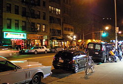
Avenue A (Manhattan)
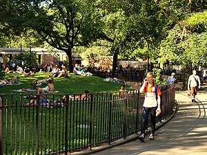 Tompkins Square Park lines Avenue A between East Seventh Street and East 10th Street. | |
 | |
| Owner | City of New York |
|---|---|
| Maintained by | NYCDOT |
| Length | 1.1 mi[1] (1.8 km) |
| Location | Manhattan, New York City |
| South end | Houston |
| North end | 14th Street |
| East | Avenue B |
| West | First Avenue |
| Construction | |
| Commissioned | March 1811 |
Avenue A is a north–south avenue located in Manhattan, New York City, east of First Avenue and west of Avenue B. It runs from Houston Street to 14th Street, where it continues into a loop road in Stuyvesant Town, connecting to Avenue B. Below Houston Street, Avenue A continues as Essex Street.
It is considered to be the western border of Alphabet City in the East Village. It is also the western border of Tompkins Square Park.
Sections[]
Under the Commissioners' Plan of 1811 that established the Manhattan street grid, the avenues would begin with First Avenue on the east side and run through Twelfth Avenue in the west. East of First Avenue the plan provided four additional lettered avenues running from Avenue A eastward to Avenue D wherever they could be fitted.[2]
While First Avenue was the easternmost avenue in most of Manhattan, several discontinuous sections were designated as Avenue A north of present-day Alphabet City.

Asser Levy Place[]
A short section of Avenue A from 23rd to 25th Streets in Kips Bay, Manhattan, was cut off from the existing section in 1947 with the construction of Stuyvesant Town and Peter Cooper Village. The two-block section was renamed in 1954 after Asser Levy, one of the first Jewish citizens of New York City, and a strong and influential advocate for civil liberties.[3][4] The eastern side of Asser Levy Place contains the Asser Levy Recreation Center,[5][6] which includes the Asser Levy Public Baths, built in 1905-08.[7][8]
Asser Levy Place closed in October 2013 to become part of the Recreation Center[9] The park now contains concrete Ping-Pong tables, a track and field, exercise equipment, and painted children's games such as hopscotch. It is being built by New York City Department of Parks and Recreation to replace the western end of the Robert Moses Playground at 42nd Street and FDR Drive being sold to the United Nations, in preparation for a future East River Greenway phase on the FDR Drive, underneath the United Nations headquarters between East 38th and 60th Streets.[10][11]

Beekman Place[]
Beekman Place, located at the headquarters of the United Nations, runs as a short street between Mitchell Place/49th Street and 51st Street. Though not part of the original Avenue A in the 1811 plan, it is named after the Beekman family (members of whom include Wilhelmus Beekman, whose namesakes also include downtown's Beekman Street and William Street), who were influential in New York City's development.[12]
Sutton Place and York Avenue[]
Sutton Place was also formerly designated as Avenue A; in its original length it ran between East 53rd and 92nd Streets. Effingham B. Sutton constructed a group of brownstones in 1875 between 57th and 58th Streets, and is said to have lent the street his name, though the earliest source found by The New York Times dates back to 1883. The New York City Board of Aldermen approved a petition to change the name from "Avenue A" to "Sutton Place", covering the blocks between 57th and 60th Streets.[13][14]
In 1928, a one-block section of Sutton Place north of East 59th Street, and all of Avenue A north of that point, was renamed York Avenue in honor of World War One US Army Sergeant Alvin York, who won the Medal of Honor for an attack in the Meuse-Argonne Offensive on October 8, 1918.[14][15] This section is the only former section of Avenue A to still use the Avenue A address system (as it only has four-digit building numbers).
Pleasant Avenue[]
The northernmost section of Avenue A, stretching between East 114th and 120th Streets in East Harlem, was renamed Pleasant Avenue in 1879.[5][16] The addresses on Pleasant Avenue are not continuous with those on Avenue A (which would be in the 2000-series if they were continuous).
See also[]
On the same position on the Manhattan street grid:
- Essex Street, Lower East Side
Other lettered avenues in Alphabet City, Manhattan:
References[]
- ^ Google (December 1, 2015). "Avenue A (Manhattan)" (Map). Google Maps. Google. Retrieved December 1, 2015.
- ^ REMARKS OF THE COMMISSIONERS FOR LAYING OUT STREETS AND ROADS IN THE CITY OF NEW YORK, UNDER THE ACT OF APRIL 3, 1807 Archived June 10, 2007, at the Wayback Machine, accessed May 2, 2007. "The avenues to the eastward of number one are marked A, B, C, and D."
- ^ "Street Named For Asser Levy". New York Daily News. February 23, 1955. p. 44. Retrieved January 21, 2021 – via newspapers.com
 .
.
- ^ "Honors Jewish Pioneer; City Renames Northern End of Avenue a for Asser Levy" (PDF). The New York Times. February 23, 1955. p. 23. ISSN 0362-4331. Retrieved January 21, 2021.
- ^ Jump up to: a b De-Classified 4-A, Forgotten NY. Accessed January 1, 2008.
- ^ NYC Parks: Asser Levy Recreation Center
- ^ "Asser Levy Recreation Center, Pool and Playground" on the New York City Department of Parks and Recreation website. Accessed:2011-02-17
- ^ New York City Landmarks Preservation Commission; Dolkart, Andrew S.; Postal, Matthew A. (2009). Postal, Matthew A. (ed.). Guide to New York City Landmarks (4th ed.). New York: John Wiley & Sons. ISBN 978-0-470-28963-1., p.88
- ^ Heather Holland (2013-10-23). "Asser Levy Place to Close Permanently to Make Way for Park". DNA Info. Archived from the original on 2014-08-26. Retrieved 2014-08-23.
- ^ Holland, Heather (October 23, 2013). "Asser Levy Place to Close Permanently to Make Way for Park". DNAinfo New York. Archived from the original on January 20, 2021. Retrieved January 19, 2021.
- ^ Foderaro, Lisa W. (September 30, 2011). "Land Deal With U.N. Would Fill a Big Gap in the Waterfront Greenway". The New York Times. ISSN 0362-4331. Retrieved January 19, 2021.
- ^ Aitken, William Benford (1912). Distinguished Families In America: Descended From Wilhelmus Beekman And Jan Thomasse Van Dyke. The Knickerbocker Press. Retrieved 2009-08-22.
- ^ Senft, Bret. "If You're Thinking of Living In/Sutton Place; A Riverside Enclave for the Well-to-Do", The New York Times, June 12, 1994. Accessed December 27, 2007.
- ^ Jump up to: a b Gray, Christopher. " Streetscapes/Sutton Place, Sutton Place South and One Sutton Place North; A Prestigious Enclave With a Name in Question", The New York Times, September 21, 2003. Accessed December 27, 2007.
- ^ Pollak, Michael. "F. Y. I.", The New York Times, August 7, 2005. Accessed October 16, 2007. "In 1928, Sutton Place from 59th to 60th Street, and Avenue A north of 60th, were renamed York Avenue in honor of Sgt. Alvin C. York (1887-1964), a World War I hero from Tennessee and a recipient of the Medal of Honor."
- ^ Pollak, Michael. F.Y.I. - They Hear Dead People", The New York Times, December 12, 2004. Accessed January 1, 2008.
External links[]
| Wikimedia Commons has media related to Avenue A (Manhattan). |
- New York Songlines: Avenue A, a virtual walking tour
- East Harlem Giglio Society
Route map:

- East Village, Manhattan
- Italian-American culture in New York City
- Streets in Manhattan