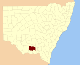
Urana County

From Wikipedia, the free encyclopedia

Map all coordinates using: OpenStreetMap 
Download coordinates as: KML
Urana
New South Wales
Urana NSW.PNG
Location in New South Wales
Lands administrative divisions around Urana:
Boyd Boyd Mitchell
Townsend Urana Mitchell
Townsend Denison Hume

Urana County is one of the 141 Cadastral divisions of New South Wales. It contains the towns of Urana and Bidgeemia.

The name Urana is believed to be derived from a local Aboriginal word,[1] and is referenced in relation to the town of Urana, New South Wales as coming from the Aboriginal word 'airana', meaning a temporary shelter (usually consisting of a simple frame of branches covered with bark, leaves, or grass).[2]

Parishes within this county[]

A full list of parishes found within this county; their current LGA and mapping coordinates to the approximate centre of each location is as follows:

Urana County NSW as shown on 1886 map)[3]
Parish LGA Coordinates
Federation Council 35°04′54″S 146°13′04″E / 35.08167°S 146.21778°E / -35.08167; 146.21778 (Betts)
Federation Council 34°58′54″S 146°17′04″E / 34.98167°S 146.28444°E / -34.98167; 146.28444 (Bingagong)
Murrumbidgee Council 35°12′54″S 145°49′04″E / 35.21500°S 145.81778°E / -35.21500; 145.81778 (Bolton)
Murrumbidgee Council 35°28′54″S 145°34′04″E / 35.48167°S 145.56778°E / -35.48167; 145.56778 (Booroobanilly)
Boree Creek Federation Council 35°04′54″S 146°39′04″E / 35.08167°S 146.65111°E / -35.08167; 146.65111 (Boree Creek)
Federation Council 35°32′54″S 146°05′04″E / 35.54833°S 146.08444°E / -35.54833; 146.08444 (Boreegerry)
Lockhart Shire 35°10′54″S 146°00′04″E / 35.18167°S 146.00111°E / -35.18167; 146.00111 (Brookong North)
Lockhart Shire 35°17′54″S 146°35′04″E / 35.29833°S 146.58444°E / -35.29833; 146.58444 (Brookong)
Murrumbidgee Council 35°05′54″S 145°49′04″E / 35.09833°S 145.81778°E / -35.09833; 145.81778 (Broome)
Murrumbidgee Council 35°02′54″S 145°59′04″E / 35.04833°S 145.98444°E / -35.04833; 145.98444 (Bundure North)
Bundure Murrumbidgee Council 35°05′54″S 145°59′04″E / 35.09833°S 145.98444°E / -35.09833; 145.98444 (Bundure)
Federation Council 35°15′54″S 146°21′04″E / 35.26500°S 146.35111°E / -35.26500; 146.35111 (Butherwa)
Murrumbidgee Council 35°01′54″S 145°52′04″E / 35.03167°S 145.86778°E / -35.03167; 145.86778 (Cadell)
Murrumbidgee Council 35°16′15″S 145°50′08″E / 35.27083°S 145.83556°E / -35.27083; 145.83556 (Carnerney)
Federation Council 35°28′54″S 146°11′04″E / 35.48167°S 146.18444°E / -35.48167; 146.18444 (Clear Hill)
Federation Council 35°30′54″S 146°10′04″E / 35.51500°S 146.16778°E / -35.51500; 146.16778 (Clear Hill)
Lockhart Shire 35°23′54″S 146°45′04″E / 35.39833°S 146.75111°E / -35.39833; 146.75111 (Clive)
Narrandera Shire 35°01′54″S 146°27′04″E / 35.03167°S 146.45111°E / -35.03167; 146.45111 (Clyde)
Federation Council 35°14′54″S 145°59′04″E / 35.24833°S 145.98444°E / -35.24833; 145.98444 (Cocketgedong)
Federation Council 34°57′54″S 146°08′04″E / 34.96500°S 146.13444°E / -34.96500; 146.13444 (Colkmannan)
Federation Council 35°07′54″S 146°06′04″E / 35.13167°S 146.10111°E / -35.13167; 146.10111 (Colombo)
Federation Council 35°23′54″S 146°05′04″E / 35.39833°S 146.08444°E / -35.39833; 146.08444 (Combermere)
Coonong Federation Council 35°11′54″S 146°10′04″E / 35.19833°S 146.16778°E / -35.19833; 146.16778 (Coonong)
Murrumbidgee Council 35°17′54″S 145°35′04″E / 35.29833°S 145.58444°E / -35.29833; 145.58444 (Coree North)
Murrumbidgee Council 35°23′54″S 145°34′04″E / 35.39833°S 145.56778°E / -35.39833; 145.56778 (Coree South)
Federation Council 35°00′54″S 146°07′04″E / 35.01500°S 146.11778°E / -35.01500; 146.11778 (Crommelin)
Cullivel Lockhart Shire 35°16′54″S 146°30′04″E / 35.28167°S 146.50111°E / -35.28167; 146.50111 (Cullivel)
Federation Council 35°04′54″S 146°04′04″E / 35.08167°S 146.06778°E / -35.08167; 146.06778 (Douglas)
Federation Council 35°22′54″S 146°22′04″E / 35.38167°S 146.36778°E / -35.38167; 146.36778 (Faed)
Lockhart Shire 35°25′54″S 146°35′04″E / 35.43167°S 146.58444°E / -35.43167; 146.58444 (Finlay)
Galore Lockhart Shire 35°10′54″S 146°45′04″E / 35.18167°S 146.75111°E / -35.18167; 146.75111 (Galore)
Goolgumbla Murrumbidgee Council 35°03′54″S 145°37′04″E / 35.06500°S 145.61778°E / -35.06500; 145.61778 (Goolgumbla)
Federation Council 35°15′54″S 146°15′04″E / 35.26500°S 146.25111°E / -35.26500; 146.25111 (Gunambill)
Federation Council 35°33′54″S 146°15′04″E / 35.56500°S 146.25111°E / -35.56500; 146.25111 (Gunambill)
Murrumbidgee Council 35°28′54″S 145°54′04″E / 35.48167°S 145.90111°E / -35.48167; 145.90111 (Hardie)
Federation Council 35°23′54″S 146°10′04″E / 35.39833°S 146.16778°E / -35.39833; 146.16778 (Hastings)
Lockhart Shire 35°17′54″S 146°40′04″E / 35.29833°S 146.66778°E / -35.29833; 146.66778 (Hebden)
Henty Federation Council 35°28′54″S 146°05′04″E / 35.48167°S 146.08444°E / -35.48167; 146.08444 (Henty)
Federation Council 34°55′54″S 146°14′04″E / 34.93167°S 146.23444°E / -34.93167; 146.23444 (Howell)
Murrumbidgee Council 35°17′54″S 145°44′04″E / 35.29833°S 145.73444°E / -35.29833; 145.73444 (Jerilderie North)
Murrumbidgee Council 35°22′54″S 145°44′04″E / 35.38167°S 145.73444°E / -35.38167; 145.73444 (Jerilderie South)
Kendall Federation Council 35°13′54″S 146°04′04″E / 35.23167°S 146.06778°E / -35.23167; 146.06778 (Kendall)
Federation Council 35°06′54″S 146°31′04″E / 35.11500°S 146.51778°E / -35.11500; 146.51778 (Lake)
Lockhart Lockhart Shire 35°12′54″S 146°46′04″E / 35.21500°S 146.76778°E / -35.21500; 146.76778 (Lockhart)
Mairjimmy Murrumbidgee Council 35°30′54″S 145°46′04″E / 35.51500°S 145.76778°E / -35.51500; 145.76778 (Mairjimmy)
Federation Council 35°06′54″S 146°21′04″E / 35.11500°S 146.35111°E / -35.11500; 146.35111 (Morundah South)
Morundah Federation Council 35°01′18″S 146°22′31″E / 35.02167°S 146.37528°E / -35.02167; 146.37528 (Morundah)
Lockhart Shire 35°11′54″S 146°30′04″E / 35.19833°S 146.50111°E / -35.19833; 146.50111 (Mucra)
Lockhart Shire 35°27′54″S 146°48′04″E / 35.46500°S 146.80111°E / -35.46500; 146.80111 (Munyabla)
Napier Lockhart Shire 35°17′54″S 146°46′04″E / 35.29833°S 146.76778°E / -35.29833; 146.76778 (Napier)
Federation Council 35°25′54″S 146°16′04″E / 35.43167°S 146.26778°E / -35.43167; 146.26778 (North Gunambill)
Murrumbidgee Council 35°21′54″S 146°01′04″E / 35.36500°S 146.01778°E / -35.36500; 146.01778 (Nowranie)
Osborne Lockhart Shire 35°11′54″S 146°41′04″E / 35.19833°S 146.68444°E / -35.19833; 146.68444 (Osborne)
Murrumbidgee Council 35°26′54″S 146°01′04″E / 35.44833°S 146.01778°E / -35.44833; 146.01778 (Palmer)
Federation Council 35°30′54″S 146°01′04″E / 35.51500°S 146.01778°E / -35.51500; 146.01778 (Palmer)
Federation Council 35°10′54″S 146°22′04″E / 35.18167°S 146.36778°E / -35.18167; 146.36778 (Piney Ridge)
Murrumbidgee Council 34°55′54″S 145°53′04″E / 34.93167°S 145.88444°E / -34.93167; 145.88444 (Pullega)
Lockhart Shire 35°27′54″S 146°40′04″E / 35.46500°S 146.66778°E / -35.46500; 146.66778 (Ross)
Murrumbidgee Council 35°05′54″S 145°42′04″E / 35.09833°S 145.70111°E / -35.09833; 145.70111 (Stanley)
Lockhart Shire 35°25′54″S 146°31′04″E / 35.43167°S 146.51778°E / -35.43167; 146.51778 (Sumner)
Jerilderie 35°09′54″S 145°58′04″E / 35.16500°S 145.96778°E / -35.16500; 145.96778 (Thurrowa)
Urana Federation Council 35°19′54″S 146°16′04″E / 35.33167°S 146.26778°E / -35.33167; 146.26778 (Urana)
Urangeline Lockhart Shire 35°21′54″S 146°31′04″E / 35.36500°S 146.51778°E / -35.36500; 146.51778 (Urangeline)
Lockhart Shire 35°27′54″S 146°44′04″E / 35.46500°S 146.73444°E / -35.46500; 146.73444 (Wallandoon)
Murrumbidgee Council 34°54′54″S 145°40′04″E / 34.91500°S 145.66778°E / -34.91500; 145.66778 (Waloona)
Federation Council 35°15′54″S 146°09′04″E / 35.26500°S 146.15111°E / -35.26500; 146.15111 (Watt)
Federation Council 34°58′54″S 146°23′04″E / 34.98167°S 146.38444°E / -34.98167; 146.38444 (Waugh)
Widgiewa Federation Council 35°11′54″S 146°16′04″E / 35.19833°S 146.26778°E / -35.19833; 146.26778 (Widgiewa)
Federation Council 35°29′54″S 146°17′04″E / 35.49833°S 146.28444°E / -35.49833; 146.28444 (Wilson)
Murrumbidgee Council 35°09′54″S 145°35′04″E / 35.16500°S 145.58444°E / -35.16500; 145.58444 (Wood)
Murrumbidgee Council 35°26′54″S 145°43′04″E / 35.44833°S 145.71778°E / -35.44833; 145.71778 (Wunnamurra)
Murrumbidgee Council 34°56′54″S 146°00′04″E / 34.94833°S 146.00111°E / -34.94833; 146.00111 (Yamma)
Murrumbidgee Council 34°59′54″S 145°48′04″E / 34.99833°S 145.80111°E / -34.99833; 145.80111 (Yanko South)
Murrumbidgee Council 34°54′54″S 145°47′04″E / 34.91500°S 145.78444°E / -34.91500; 145.78444 (Yanko)
Murrumbidgee Council 35°22′54″S 145°54′04″E / 35.38167°S 145.90111°E / -35.38167; 145.90111 (Yathong South)
Murrumbidgee Council 35°17′17″S 145°55′06″E / 35.28806°S 145.91833°E / -35.28806; 145.91833 (Yathong)

References[]

  1. ^ "Urana". Geographical Names Register (GNR) of NSW. Geographical Names Board of New South Wales. Retrieved 11 August 2013. Edit this at Wikidata
  2. ^ Jervis, James, 'The Western Riverina: A History of Its Development', Royal Australian Historical Society Journal and Proceedings, Vol. XXXVIII 1952, pp. 242-3.
  3. ^ The New atlas of Australia (John Sands 1886) map 21.
Retrieved from ""