Utsjoki
Utsjoki
Utsjoki – Ohcejohka Uccjuuhâ Uccjokk | |
|---|---|
Municipality | |
| Utsjoen kunta Ohcejoga gielda Utsjoki kommun | |
 Utsjoki Church and a log cabin | |
 Coat of arms | |
 Location of Utsjoki in Finland | |
| Coordinates: 69°54′N 027°01′E / 69.900°N 27.017°ECoordinates: 69°54′N 027°01′E / 69.900°N 27.017°E | |
| Country | |
| Region | Lapland |
| Sub-region | Northern Lapland |
| Charter | 1876 |
| Government | |
| • Municipal manager | Vuokko Tieva-Niittyvuopio |
| Area (2018-01-01)[1] | |
| • Total | 5,372.00 km2 (2,074.14 sq mi) |
| • Land | 5,144.27 km2 (1,986.21 sq mi) |
| • Water | 227.51 km2 (87.84 sq mi) |
| Area rank | 10th largest in Finland |
| Population (2021-03-31)[2] | |
| • Total | 1,219 |
| • Rank | 289th largest in Finland |
| • Density | 0.24/km2 (0.6/sq mi) |
| Population by native language | |
| • Finnish | 51.6% (official) |
| • Swedish | 0.2% |
| • Sami | 46.6% |
| • Others | 1.7% |
| Population by age | |
| • 0 to 14 | 12.6% |
| • 15 to 64 | 56.4% |
| • 65 or older | 30.9% |
| Time zone | UTC+02:00 (EET) |
| • Summer (DST) | UTC+03:00 (EEST) |
| Municipal tax rate[5] | 21% |
| Website | www.utsjoki.fi |

Utsjoki (Finnish: [ˈutsjoki]; Northern Sami: Ohcejohka [ˈoht͡seˌjohka]; Inari Sami: Uccjuuhâ; Skolt Sami: Uccjokk; Norwegian: Utsjok) is a municipality in Finland, the northernmost in the country. It is in Lapland and borders Norway as well as the municipality of Inari. The municipality was founded in 1876. It has a population of 1,219 (31 March 2021)[2] and covers an area of 5,372.00 square kilometres (2,074.14 sq mi) of which 227.51 km2 (87.84 sq mi) is water.[1] The population density is 0.24 inhabitants per square kilometre (0.62/sq mi).
Utsjoki has two official languages: Finnish and Northern Sami. It is the municipality in Finland with the largest portion of official Sami speakers; 46.6% of the population.[3]
The border to Norway follows the river Teno which flows into the Arctic Sea. The northernmost village in Finland and in the European Union is Nuorgam which is also the northernmost land border crossing in the world.[citation needed]
Utsjoki is at the northern end of highway 4, the longest highway in Finland. The European route E75 runs along the Sami Bridge further to Norway.[citation needed]
The Kevo nature reserve is in the municipality. It covers a territory of 712 km2 (275 sq mi) and there is a 63 km (39 mi) long hiking trail. The trail partly follows the edge of the Kevo canyon.[citation needed]
Villages in Utsjoki[]
Nuorgam, Utsjoki centre, Nuvvus, , , , Karigasniemi and Kaamasmukka.
Geography[]
Topography[]
The Utsjoki region is flatter and lower in altitudes than many others. Large areas of Utsjoki are less than 300 m above sea level. Many fjell summits are less than 500 m high. In general, the topography is smooth and the fjells slope gently. The summits are very flat and large in area as is typical of old peneplain surfaces.
Vegetation[]
In general, the forest limit is located at altitudes between 300 and 400 meters. In northernmost Finland, the tree line on north facing slopes is just above an altitude of 100 meters. Heaths extend above the tree line. The lower heathlands are dominated by some shrubs such as Betula nana, Vaccinium myrtillus and Empetrum hermaphroditum, whereas in the fjell at higher elevations heaths show Salix herbacea, Empetrum and alpine grasses with lichens and mosses. On the fjell tops blockfields and wind blown heaths with lichens and mosses as well as bare rock slabs are found. Patterned ground occurs regularly, often stone polygons and stone stripes on slopes.
Climate[]
The "midnight sun" is above the horizon from 17 May to 28 July (73 days), and the period with continuous night lasts a bit shorter, polar night from 26 November to 15 January (51 days). Utsjoki, like most of Finland, has a subarctic climate (Köppen Dfc). Being the northernmost municipality in Finland, Utsjoki is a very cold place with an annual average temperature below freezing. Utsjoki is also the driest place in Finland, as the average annual precipitation varies between 371 and 433 mm, depending on the topography. The driest year on record was 1986 when only 234 mm of precipitation fell at the Outakoski weather station.[6]
Extremely low temperatures and low precipitations result in thin snow cover during all winter. The wind velocity strongly increases with higher elevations and this is of great importance for the distribution of the snow. The exposed hilltops usually have no snow cover during winter. This favours the cooling of the ground and development of permafrost.
Permafrost[]
Palsas are a typical permafrost feature in northern Finland, and palsa mires have quickened interest very early.[7] Permafrost formation in palsas is based on the properties of peat. Dry peat is a good insulator during the summer heat, but frozen peat in winter is conducting heat, and the winter cold can penetrate deep into the peat layers. Due to these physical properties, palsas may be formed and preserved even in a climate where the mean annual air temperature is just at the freezing point.
Permafrost has been found in many palsa mires in the Kevo and Utsjoki regions.[8] After detailed studies on palsas, researchers were convinced until 1982, that "so far permafrost has been found and probably exists only in mires in the cores of palsas". The permafrost core in palsas is easy to detect by digging or sounding with a steel rod, the proof of frozen bedrock necessitates modern geophysical techniques as geoelectrical soundings. They allow to measure even the thickness of frozen bedrock due to its higher specific electrical resistance.
Matti Seppälä (1941-2020) was undoubtedly the foremost expert on palsas. Based on existing innovative research in Scandinavia[9] [10] he suggested to look for the general permafrost distribution in the mountains also in northernmost Finnland. The field campaign in summer 1985 in Utsjoki was supported by the Academy of Finland, the University of Helsinki and the German Research Foundation. The results were quite surprising for most scientists in Finland. Above the timber Iine a minimum permafrost thickness of ten to fifty meters was recorded with geoelectrical soundings.[11]
It seems obvious that permafrost is widespread on fjell summits of northern Finland. The Puollamoaivi mountain (432 m high) is located some 13 km NE of the Kevo Subarctic Research Station. Close to the Skallovarri palsa mire about 290 m a. s. I., an estimated permafrost thickness of over 100 meters may be expected at an altitude of 360 m, just 30-70 m higher than the surface of the palsa mire. It is concluded therefore that all sites on the crest of Skallovarri (Puollamoaivi) show the existence of permafrost, but its thickness seems to be different. These findings were confirmed with similar results in the adjacent Peldojoki, Hietatievat, Peera sites, where permafrost exists in debris as well as in bedrock. This is also of importance in the construction business, e.g. for deep foundations for telecommunication masts.
| hideClimate data for Utsjoki Kevo, 1981–2010 normals, records 1959–present | |||||||||||||
|---|---|---|---|---|---|---|---|---|---|---|---|---|---|
| Month | Jan | Feb | Mar | Apr | May | Jun | Jul | Aug | Sep | Oct | Nov | Dec | Year |
| Record high °C (°F) | 6.2 (43.2) |
6.3 (43.3) |
9.2 (48.6) |
15.7 (60.3) |
30.5 (86.9) |
32.8 (91.0) |
34.2 (93.6) |
31.5 (88.7) |
24.3 (75.7) |
13.7 (56.7) |
8.7 (47.7) |
7.1 (44.8) |
34.2 (93.6) |
| Average high °C (°F) | −9.2 (15.4) |
−8.1 (17.4) |
−3.2 (26.2) |
2.4 (36.3) |
7.9 (46.2) |
14.7 (58.5) |
18.3 (64.9) |
15.4 (59.7) |
9.6 (49.3) |
2.3 (36.1) |
−4.4 (24.1) |
−7.5 (18.5) |
3.2 (37.8) |
| Daily mean °C (°F) | −14.0 (6.8) |
−12.8 (9.0) |
−8.2 (17.2) |
−2.5 (27.5) |
3.7 (38.7) |
9.6 (49.3) |
13.1 (55.6) |
10.7 (51.3) |
5.7 (42.3) |
−0.5 (31.1) |
−8.3 (17.1) |
−12.3 (9.9) |
−1.3 (29.7) |
| Average low °C (°F) | −19.1 (−2.4) |
−18.0 (−0.4) |
−13.8 (7.2) |
−7.7 (18.1) |
−0.5 (31.1) |
5.1 (41.2) |
8.5 (47.3) |
6.5 (43.7) |
2.3 (36.1) |
−3.4 (25.9) |
−12.5 (9.5) |
−17.3 (0.9) |
−5.8 (21.6) |
| Record low °C (°F) | −48.2 (−54.8) |
−47.9 (−54.2) |
−39.1 (−38.4) |
−31.9 (−25.4) |
−20.9 (−5.6) |
−3.4 (25.9) |
−0.1 (31.8) |
−3.9 (25.0) |
−11.9 (10.6) |
−28.9 (−20.0) |
−36.1 (−33.0) |
−41.4 (−42.5) |
−48.2 (−54.8) |
| Average precipitation mm (inches) | 27 (1.1) |
24 (0.9) |
21 (0.8) |
25 (1.0) |
27 (1.1) |
50 (2.0) |
72 (2.8) |
57 (2.2) |
38 (1.5) |
39 (1.5) |
28 (1.1) |
25 (1.0) |
433 (17) |
| Source 1: FMI climatological normals for Finland 1981–2010[12] | |||||||||||||
| Source 2: record highs and lows[13] | |||||||||||||
| hideClimate data for Utsjoki Outakoski, 1981–2010 normals | |||||||||||||
|---|---|---|---|---|---|---|---|---|---|---|---|---|---|
| Month | Jan | Feb | Mar | Apr | May | Jun | Jul | Aug | Sep | Oct | Nov | Dec | Year |
| Average precipitation mm (inches) | 22 (0.9) |
20 (0.8) |
16 (0.6) |
19 (0.7) |
17 (0.7) |
38 (1.5) |
61 (2.4) |
54 (2.1) |
35 (1.4) |
38 (1.5) |
29 (1.1) |
22 (0.9) |
371 (14.6) |
| Source: FMI open data, 1981–2010[14] | |||||||||||||
Gallery[]

Mantojärvi, near Utsjoki village

Utsjoki seen from Norway
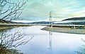
The Sami Bridge connects Utsjoki to Norway
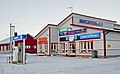
Samimootor, a car repair shop and filling station in Nuorgam, Utsjoki


Notable people[]
- Inger-Mari Aikio-Arianaick, writer, born in Utsjoki in 1961.
- Pigga Keskitalo, Sámi academic, born in Utsjoki in 1972.
- Helvi Poutasuo (1943–2017), teacher, translator, editor, politician
- Irja Seurujärvi-Kari (born 1947), politician and academic
References[]
- ^ Jump up to: a b "Area of Finnish Municipalities 1.1.2018" (PDF). National Land Survey of Finland. Retrieved 30 January 2018.
- ^ Jump up to: a b "Preliminary population structure by area, 2021M01*-2021M03*". StatFin (in Finnish). Statistics Finland. Retrieved 2 May 2021.
- ^ Jump up to: a b "Population according to language and the number of foreigners and land area km2 by area as of 31 December 2008". Statistics Finland's PX-Web databases. Statistics Finland. Retrieved 29 March 2009.
- ^ "Population according to age (1-year) and sex by area and the regional division of each statistical reference year, 2003-2020". StatFin. Statistics Finland. Retrieved 2 May 2021.
- ^ "List of municipal and parish tax rates in 2021" (PDF). Tax Administration of Finland. 1 December 2020. Retrieved 10 April 2021.
- ^ [1]
- ^ Ruuhijärvi, Rauno (1960). "Über die regionale Einteilung der nordfinnischen Moore". Annales Botanici Societatis Zoologicae Botanicae Fennicae 'Vanamo' (in German). 31 (1): 360 pp.
- ^ Seppälä, Matti (1979). "Recent palsa studies in Finland". Acta Universitatis Ouluensis. Ser. A (82): 81–87.
- ^ King, Lorenz (1983). "High Mountain Permafrost in Scandinavia". Permafrost: Fourth International Conference, Proceedings: 612–617.
- ^ King, Lorenz (1982). "Qualitative und quantitative Erfassung von Permafrost in Tarfala (Schwedisch-Lappland) und Jotunheimen (Norwegen) mit Hilfe geoelektrischer Sondierungen". Zeitschrift für Geomorphologie (in German). Suppl.-Band (43): 139–160.
- ^ King, Lorenz; Seppälä, Matti (1987). "Permafrost thickness and distribution in Finnish Lapland - Results of geoelectrical soundings" (PDF). Polarforschung. 57 (3): 127–147. Retrieved 2021-02-25.
- ^ "FMI normals 1981-2010" (PDF). fmi.fi. Retrieved 26 April 2016.
- ^ "FMI open data". FMI. Retrieved 26 April 2016.
- ^ "FMI open data". FMI. Retrieved 21 March 2020.
External links[]
![]() Media related to Utsjoki at Wikimedia Commons
Media related to Utsjoki at Wikimedia Commons
- Municipality of Utsjoki (in Finnish and Northern Sami)
- Hotel Luossajohka Utsjoki

| show Authority control |
|---|
- Utsjoki
- Sámi-language municipalities
- Populated places established in 1876
- 1876 establishments in Finland