Utupua
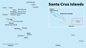


Utupua is an island in the Santa Cruz Islands, located 66 km to the Southeast of the main Santa Cruz group, between Vanikoro and Santa Cruz proper (Nendo Island). This island belongs administratively to the Temotu Province of the Solomon Islands.
Geography[]
Utupua is a high u-shaped island surrounded by a coral reef. Its land surface is 69.0 square kilometres (26.6 square miles) and its highest point 380 metres (1,247 feet).
Utupua has a population of 848 inhabitants (1999 census) scattered in small villages. The main villages in the island are: Avita, Malombo, Tanimbili, Apakho and Nembao.
Utupua has a forested path that leads to viewpoints overlooking the coral reef that encloses the island.[citation needed]
Languages[]
Three Oceanic languages are spoken on Utupua:[1]
History[]
First sighting by Europeans was in September 1595 by the second Spanish expedition of Álvaro de Mendaña. More precisely it was sighted by Lorenzo Barreto while in command of one of the smaller vessels on a local voyage round the then called Santa Cruz, which is today's Nendo Island.[2][3]
Notes[]
References[]
- John Lynch; Malcolm Ross; Terry Crowley (2002). The Oceanic languages. Richmond, Surrey: Curzon. ISBN 9780700711284. OCLC 48929366.
- [1]
| show Authority control |
|---|
Coordinates: 11°20′S 166°30′E / 11.333°S 166.500°E

This Solomon Islands location article is a stub. You can help Wikipedia by . |
- Islands of the Solomon Islands
- Solomon Islands geography stubs