Verkhovyna Raion
Verkhovyna Raion
Верховинський район | |
|---|---|
Raion | |
| Verkhovynskyi raion | |
 Coat of arms | |
 | |
| Coordinates: 48°1′51″N 24°48′6″E / 48.03083°N 24.80167°ECoordinates: 48°1′51″N 24°48′6″E / 48.03083°N 24.80167°E | |
| Country | |
| Region | |
| Established | 1966 |
| Admin. center | Verkhovyna |
| Subdivisions | 3 hromadas |
| Government | |
| • Governor | Vasyl Hondurak |
| Area | |
| • Total | 1,254 km2 (484 sq mi) |
| Population (2021)[1] | |
| • Total | 30,399 |
| • Density | 24/km2 (63/sq mi) |
| Time zone | UTC+02:00 (EET) |
| • Summer (DST) | UTC+03:00 (EEST) |
| Postal index | 285280 |
| Area code | ? |
| Website | Raion Profile (Verkhovna Rada) Raion Administration |

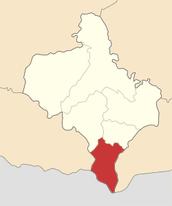
Verkhovyna Raion (Ukrainian: Верхови́нський райо́н, romanized: Verchovynśkyj rajon) is a raion (district) of Ivano-Frankivsk Oblast (region). The urban-type settlement of Verkhovyna is the administrative center of the raion. The raion was reinstated in 1966 (initially in 1939 as Zhabie Raion) out of the Kosiv Raion. Population: 30,399 (2021 est.)[1]
Subdivisions[]

On 18 July 2020, as part of the administrative reform of Ukraine, the number of raions of Ivano-Frankivsk Oblast was reduced to six, however, the area of Verkhovyna Raion was essentially unchanged.[2][3] The January 2020 estimate of the raion population was 30,479 (2020 est.)[4]
Both before and after 2000, the raion consisted of three hromadas:[5]
- Biloberizka rural hromada with the administration in the selo of ;
- with the administration in Verkhovyna;
- with the administration in the selo of .
Geography[]
To the west of Verkhovyna Raion lies Zakarpattia Region, while to its east - Chernivtsi Region. To the northwest there lies the Nadvirna Raion and to the northeast - the Kosiv Raion. The biggest river, Cheremosh runs along the Chernivtsi Region and serves as the natural border. Most of the raion is covered with forest.
The raion is located at the extreme south of the Ivano-Frankivsk Region and has a 45 kilometres (28 mi) state border with Romania along the . Infrastructure in the raion is underdeveloped and it does not have rail or air connection due to its highland relief. On the other hand it is widely used for mountain tourism and hiking.
Among notable landmarks there is a regional museum of local history "Hutsulshchyna", abandoned Polish Astronomical Observatory Biały Słoń which is used for as a mountain shelter with a small search and rescue team.
The raion is divided into one urban commune (township) and 21 rural communes (councils). It lies in the historical region of Pokuttya.
List of communes[]
- Verkhovyna (town)
- Vipche (village)
- Bystrets
- Dzembronya
- Biloberizka
- Bukovets
- Cheretiv
- Verkhniy Yaseniv
- Rivnya
- Holovy
- Chorna Richka
- Holoshyna
- Hrynyava
- Bila Richka
- Dovhopole
- Kokhan
- Polyanky
- Zamahora
- Zelene
- Burkut
- Topilche
- Yavirnyk
- Iltsi
- Velykyi Khodak
- Krasnyk
- Krasnoyillya
- Vyhoda
- Kryvopillya
- Volova
- Stayishche
- Kryvorivnia
- Berezhnytsia
- Perekhresne
- Probiynivka
- Hramotne
- Stovpni
- Hramotne
- Stebni
- Usteriky
- Khorotseve
- Barvinkiv
- Yablunytsia
- Senkivske
- Cheremoshna
References[]
- ^ a b "Чисельність наявного населення України (Actual population of Ukraine)" (PDF) (in Ukrainian). State Statistics Service of Ukraine. Retrieved 11 July 2021.
- ^ "Про утворення та ліквідацію районів. Постанова Верховної Ради України № 807-ІХ". Голос України (in Ukrainian). 2020-07-18. Retrieved 2020-10-03.
- ^ "Нові райони: карти + склад" (in Ukrainian). Міністерство розвитку громад та територій України.
- ^ "Чисельність наявного населення України (Actual population of Ukraine)" (PDF) (in Ukrainian). State Statistics Service of Ukraine. Retrieved 30 September 2020.
- ^ "Верховинська районна рада (состав до 2020 г.)" (in Russian). Портал об'єднаних громад України.
Places adjacent to Verkhovyna Raion | |
|---|---|
| Settlements | ||
|---|---|---|
- Verkhovyna Raion
- Raions of Ivano-Frankivsk Oblast