Villeray–Saint-Michel–Parc-Extension
Villeray–Saint-Michel–Parc-Extension | |
|---|---|
 Former Park Avenue train station (Gare Jean-Talon) | |
 | |
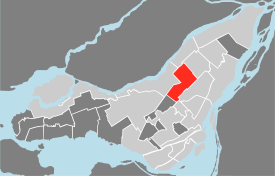 Location of Villeray–Saint-Michel–Parc-Extension on the Island of Montreal. (Grey areas indicate demerged municipalities). | |
| Country | |
| Province | |
| Region | Montréal |
| Established | January 1, 2002 |
| Electoral Districts Federal | Papineau Saint-Léonard—Saint-Michel |
| Provincial | Laurier-Dorion Viau |
| Government | |
| • Type | Borough |
| • Mayor | (Projet Montréal) |
| • Federal MP(s) | Justin Trudeau (LIB) Patricia Lattanzio (LIB) |
| • Quebec MNA(s) | Andrés Fontecilla (QS) Frantz Benjamin (PLQ) |
| Area | |
| • Total | 16.5 km2 (6.4 sq mi) |
| Population (2016) | |
| • Total | 143,853 |
| • Density | 8,723.7/km2 (22,594/sq mi) |
| • Dwellings | 64,900 |
| Time zone | UTC-5 (EST) |
| • Summer (DST) | UTC-4 (EDT) |
| Postal code(s) | H3N, H2P, H2R, H1Z |
| Area code(s) | (514) and (438) |
| Access Routes[4] | |
| Website | https://montreal.ca/villeray-saint-michel-parc-extension |
Villeray–Saint-Michel–Parc-Extension is a borough (arrondissement) in the city of Montreal, Quebec. It had a population of 143,853 according to the 2016 Census and a land area of 16.5 square kilometres (6.4 sq mi).
The borough of Villeray–Saint-Michel–Parc-Extension was created on January 1, 2002, following the municipal reorganization of Montreal. The borough includes the neighbourhoods of Villeray, Saint-Michel, and Parc-Extension.
History[]
Until the late Nineteenth century, the area that today comprises the borough of Villeray–Saint-Michel–Parc-Extension was predominately rural and dotted with farms. The inauguration of the Canadian Pacific Railway in 1878 and the arrival of electric streetcars in 1892 permitted the growth of Villeray. It was also in this era that the Italian immigrant community chose the neighbourhood as their preferred location.
In the early Twentieth century, Park Extension became industrialized, and a dozen quarries opened which led to the economic development of the area. Beginning in the 1940s, the exploitation of the Miron and Francon quarries attracted workers to Saint Michel and Park Extension.
Construction of the Metropolitan Expressway was completed in 1959. It cut the area in two, but also attracted multiple industries, which opened along the expressway. In less than twenty years, the population of Saint Michel increased from 6,000 to 68,000 inhabitants.
Jobs derived from competing industries along with the efficient transportation infrastructure resulted in strong demographic growth. The growth of the manufacturing sector, notably the textile industry, were incentives for new immigrants to settle in the borough.
The borough of Villeray–Saint-Michel–Parc-Extension was created on January 1, 2002, following the municipal reorganization of Montreal. The borough includes three neighbourhoods that were part of Montreal before the reorganization:Villeray, Saint-Michel, and Park Extension. The Saint-Michel neighbourhood was formerly an independent city known as Saint-Michel-de-Laval which was annexed to Montreal in 1968. Villeray was once also an autonomous municipality but has been part of the city of Montreal since 1905. Parc Extension left the parish of St-Laurent to join the city of Montreal in 1910.
Geography[]
Located in north central Montreal, the pipe-shaped borough is bordered by Ahuntsic-Cartierville to the northwest, Montreal North to the northeast, Saint Leonard to the east, Rosemont—La Petite-Patrie to the southeast, Outremont to the southwest, and Mount Royal to the west.
Saint-Michel is the easternmost neighbourhood of the borough, Park Extension is the westernmost neighbourhood and Villeray is in the centre.
Government[]
Municipal[]

The current borough mayor is Laurence Lavigne Lalonde of Projet Montréal.
The borough is divided into four districts located in three different neighborhoods. The districts bear the same name as their respective neighborhood with the exception of François-Perreault which is part of the Saint-Michel and Villeray neighborhoods.
- Saint-Michel
- François-Perreault
- Park Extension
- Villeray
Borough council[]
| 2017 Montreal Municipal Elections | |||
|---|---|---|---|
| District | Position | Name | Party |
| — | Borough mayor City councillor |
Giuliana Fumagalli | Quartiers Montréal |
| François-Perrault | City councillor | Projet Montréal | |
| Parc-Extension | City councillor | Mary Deros | Ensemble Montréal |
| Saint-Michel | City councillor | Ensemble Montréal | |
| Villeray | City councillor | Projet Montréal | |
| 2021 Montreal Municipal Elections[5] | |||
|---|---|---|---|
| District | Position | Name | Party |
| — | Borough mayor City councillor |
Projet Montréal | |
| François-Perrault | City councillor | Projet Montréal | |
| Parc-Extension | City councillor | Mary Deros | Ensemble Montréal |
| Saint-Michel | City councillor | Ensemble Montréal | |
| Villeray | City councillor | Projet Montréal | |
Federal and provincial[]
The borough is divided among the following federal ridings:[2]
It is divided among the following provincial electoral districts:[3]
- Laurier-Dorion
- Viau
Demographics[6][]
| Year | Pop. | ±% |
|---|---|---|
| 1966 | 201,296 | — |
| 1971 | 195,480 | −2.9% |
| 1976 | 176,583 | −9.7% |
| 1981 | 158,437 | −10.3% |
| 1986 | 149,496 | −5.6% |
| 1991 | 143,540 | −4.0% |
| 1996 | 141,663 | −1.3% |
| 2001 | 145,485 | +2.7% |
| 2006 | 142,825 | −1.8% |
| 2011 | 142,222 | −0.4% |
| 2016 | 143,853 | +1.1% |
| Language | Population | Percentage (%) |
|---|---|---|
| French | 71,815 | 57% |
| English | 12,545 | 10% |
| Other languages | 41,290 | 33% |
The 2016 census found that 88% of the population only spoke one language at home. The five most common of these languages include French (57%), English (10%), Spanish (5.9%), Arabic (3.25%) and Vietnamese (2.9%).[7]
| Language | Population | Percentage (%) |
|---|---|---|
| French | 62,900 | 46% |
| English | 8,025 | 6% |
| Other languages | 64,540 | 48% |
According to 2016 census, 48% of residents grew up learning a language other than French and English. Of these other languages, the most common are Spanish (8.5%), Arabic (6.35%) , Creole languages (4.23%), Italian (4.1%) and Greek (3.25%).[8]
| Ethnicity | Population | Percentage (%) |
|---|---|---|
| Not a visible minority | 76,025 | 53.3% |
| Visible minorities | 66,660 | 46.7% |
Features[]
It is served by the Orange and Blue lines of the Montreal Metro. It is traversed and partly delimited by Autoroute 40 (Metropolitan Aut.) and Autoroute 19 (Papineau Ave.)
Attractions in the area include the old Park Avenue train station (now containing Parc Metro station and near the Parc commuter train station), Jarry Park, and (including the Cirque du Soleil and the École nationale du cirque). The former Miron and Francon quarries are also located here.
The former studios of CTV Montreal, TQS, CFCF radio & CFQR-FM (now CKBE-FM) were located in the Parc Extension section of the borough. Today, the borough hall is at the former studios of those stations on 405 Ogilvy Avenue.
Education[]

The Commission scolaire de Montréal (CSDM) operates French-language public schools.
The English Montreal School Board (EMSB) operates English-language schools.
The Montreal Public Libraries Network operates the Le Prévost, Parc-Extension, and Saint-Michel libraries.
See also[]
- Boroughs of Montreal
- Districts of Montreal
- Municipal reorganization in Quebec
- Stade Jarry
- Parc Jarry
- Park Extension
References[]
- ^ Ministère des Affaires Municipales et Régions: Villeray–Saint-Michel–Parc-Extension (Montreal)
- ^ a b Parliament of Canada Federal Riding History: PAPINEAU (Quebec)
Parliament of Canada Federal Riding History: SAINT-LÉONARD--SAINT-MICHEL (Quebec)
Parliament of Canada Federal Riding History: AHUNTSIC (Quebec)
Parliament of Canada Federal Riding History: OUTREMONT (Quebec) - ^ a b Chief Electoral Officer of Québec - 40th General Election Riding Results: LAURIER-DORION
Chief Electoral Officer of Québec - 40th General Election Riding Results: VIAU - ^ Official Transport Quebec Road Map
- ^ "Montreal Municipal Election Results 2021". Global News. November 8, 2021.
{{cite web}}: CS1 maint: url-status (link) - ^ http://ville.montreal.qc.ca/pls/portal/docs/PAGE/MTL_STATS_FR/MEDIA/DOCUMENTS/PROFIL_SOCIOD%C9MO_VILLERAY%20ST-MICHEL%20PARC-EX%202016.PDF
- ^ "Sociodemographic profile (2016 census)" (PDF). May 2018.
{{cite web}}: CS1 maint: url-status (link) - ^ "Sociodemographic Profile 2016" (PDF). May 2018.
{{cite web}}: CS1 maint: url-status (link)
External links[]
- Borough website (in French)
- Historical building of borough Villeray
- Villeray Saint-Michel Parcextension (in French)
Places adjacent to Villeray–Saint-Michel–Parc-Extension | ||||||||||||||||
|---|---|---|---|---|---|---|---|---|---|---|---|---|---|---|---|---|
| ||||||||||||||||
Coordinates: 45°32′57″N 73°36′49″W / 45.549152°N 73.61368°W

- Villeray–Saint-Michel–Parc-Extension
- Boroughs of Montreal
- 2002 establishments in Quebec