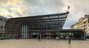
Vincennes station
Vincennes | |||||||||||||||
|---|---|---|---|---|---|---|---|---|---|---|---|---|---|---|---|
| RER station | |||||||||||||||
 | |||||||||||||||
| Location | France | ||||||||||||||
| Coordinates | 48°50′51″N 2°26′01″E / 48.84742°N 2.433524°ECoordinates: 48°50′51″N 2°26′01″E / 48.84742°N 2.433524°E | ||||||||||||||
| Owned by | RATP | ||||||||||||||
| Operated by | RATP | ||||||||||||||
| Line(s) | |||||||||||||||
| Platforms | 2 | ||||||||||||||
| Tracks | 2 | ||||||||||||||
| Other information | |||||||||||||||
| Station code | 87758110 | ||||||||||||||
| Fare zone | 2 | ||||||||||||||
| History | |||||||||||||||
| Opened | 22 September 1859 | ||||||||||||||
| Passengers | |||||||||||||||
| 2015 | 6,526,978 | ||||||||||||||
| Services | |||||||||||||||
| |||||||||||||||

Vincennes (French pronunciation: [vɛ̃sɛn] (![]() listen)) is a station on RER A the commune of Vincennes, Val-de-Marne.
listen)) is a station on RER A the commune of Vincennes, Val-de-Marne.
Service[]
Vincennes is served by both eastern branches of the RER A line, the A2 towards Boissy-Saint-Léger, and the A4 towards Marne-la-Vallée–Chessy. It is the only station on the RER A in zone 2 and the last before the line splits into the A2 and A4.
Bus connections[]
The station is served by several buses:
 RATP Bus network lines: , , , , , and ;[1]
 Noctilien network night bus lines: N11 and N33.[2]
References[]
- ^ "Plan du réseau de bus à l'Est de Paris (Secteur n°10)" [Map of the RATP bus network to the east of Paris (Sector n° 10).] (PDF). Ratp.fr (Color map showing the names of bus stops and main streets.) (in French). RATP Group. May 2020. Retrieved 19 August 2020.
- ^ "Plan du réseau Noctilien (2017) - (Secteur : Paris & Sud-Est)" [Map of the night bus (Noctilien) network (2017) - (Sector: Paris and its south-eastern suburbs).] (PDF). Ratp.fr (Color map showing the names of the bus stops and the cities served.) (in French). RATP Group. April 2017. Retrieved 19 August 2020.
| Wikimedia Commons has media related to Gare de Vincennes. |
This Paris RER article is a stub. You can help Wikipedia by . |
Categories:
- Réseau Express Régional stations
- Railway stations in France opened in 1859
- Railway stations in Val-de-Marne
- Paris RER stubs