Vinkeveen
show This article may be expanded with text translated from the corresponding article in Dutch. (August 2021) Click [show] for important translation instructions. |
Vinkeveen | |
|---|---|
 Coat of arms | |
 A vector map of Vinkeveen en Waverveen. Waverveen is in red and Vinkeveen (split up by neighborhood) is in light pink, except for the northwest corner which is the hamlet of Nessersluis. Grey is the municipality of De Ronde Venen in March of 2009; however, in 2011, it expanded its territory (growing northeastward) considerably. | |
| Coordinates: 52°12′46″N 4°55′38″E / 52.21278°N 4.92722°E | |
| Country | Netherlands |
| Province | Utrecht |
| Municipality | De Ronde Venen |
| Population (2020) | 9,330 |
| Dialling code | 0297 |

Vinkeveen is a town in the Dutch province of Utrecht. It is a part of the municipality of De Ronde Venen, and lies about 18 km south of Amsterdam.
The neighbourhood of Vinkeveen, which covers the town of Vinkeveen and the neighbouring hamlet of Achterbos, has about 9330 inhabitants.[1]
Vinkeveen used to be a separate municipality. It merged with Waverveen in 1841, to form the municipality Vinkeveen en Waverveen. In 1989 there was a reorganisation of local governments, and Vinkeveen became a part of De Ronde Venen.

Vinkeveen is mainly famous for the Vinkeveense Plassen (Lakes of Vinkeveen), an area of lakes and sand islands east of the village. It is an important recreational area, with facilities for swimming, diving and yachting. A permit is required for recreational diving in the lake. There is a marina on the north shore of the lakes.
Gallery[]

The landscape with wide waters and narrow roads in the hamlet of Demmerik in Vinkeveen Gem De Ronde Venen.
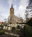
A church in Vinkeveen

Canal access to houses

An historical monument in Vinkeveen


References[]
| show Authority control |
|---|
Coordinates: 52°13′N 4°56′E / 52.217°N 4.933°E
This Utrecht location article is a stub. You can help Wikipedia by . |
- Populated places in Utrecht (province)
- Former municipalities of Utrecht (province)
- De Ronde Venen
- Utrecht (province) geography stubs