Volosianka
Volosianka
Волосянка | |
|---|---|
 | |
 Volosianka | |
| Coordinates: 48°46′48″N 23°25′42″E / 48.78000°N 23.42833°ECoordinates: 48°46′48″N 23°25′42″E / 48.78000°N 23.42833°E | |
| Country | |
| Province | |
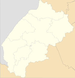
| District | |
| Established | 1572 |
| Area | |
| • Total | 301 km2 (116 sq mi) |
| Elevation /(average value of) | 673 m (2,208 ft) |
| Population | |
| • Total | 1,452 |
| • Density | 48,239/km2 (124,940/sq mi) |
| Time zone | UTC+2 (EET) |
| • Summer (DST) | UTC+3 (EEST) |
| Postal code | 82663 |
| Area code | +380 3251 |
| Website | село Волосянка (Ukrainian) |

Volosianka (Ukrainian: Волося́нка, Polish: Wołosianka) is a village (selo) in Skole Raion, Lviv Oblast, of Western Ukraine. It is located in the Ukrainian Carpathians, within the limits of the Eastern Beskids. The population of village is 1452 persons. Local government – Volosiankivska village council.[1] Volosiankivska village council includes village Khashchovania and Yalynkuvate.
The first written mention of Volosianka which dates from the year 1572. [2]
Geography[]
Village are located in the valley of the rivers Slavka River and Yalynkuvata River. West of the village are the vertices Vysokyy Verh[3] (1,242 metres (4,070 ft)), Plischka (1,032.2 metres (3,386 ft)), Mount Yarochysche (987 metres (3,240 ft)) and Mount Yalyna (1,164.5 metres (3,821 ft)). In the south is Mount Ilsa (1,064.5 metres (3,492 ft)).
The village Volosianka is situated in the 145 kilometres (90 mi) from the regional center Lviv, 36 kilometres (22 mi) from the district center Skole, and 10 kilometres (6.2 mi) from Slavske.[4]
Attractions[]
In this village there are an architectural monument of national importance. That is the wooden Church of the Holy Eucharist and a belfry.[5]
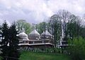
Church of the Holy Eucharist 1804 (wood)

A newly built the temple of transfer St. Nicholas relics

References[]
- ^ Волосянківська сільська рада (in Ukrainian)
- ^ Село Волосянка (Львівська обл.): карта вулиць, фото (in Ukrainian)
- ^ Гора Високий Верх
- ^ DELLA
- ^ Пам'ятки архітектури Сколівського району (in Ukrainian)
External links[]
- natural attractions
- weather.in.ua
- Волосянка. Церква Пресвятої Євхаристії (in Ukrainian)
- Волосянківська сільська рада (in Ukrainian)
- Населенні пункти Сколівського району - Волосянка (in Ukrainian)
- Туризм и отдых в Украине. Достопримечательности Украины (Церковь Преображення Господнего (Церковь Пресвятой Евхаристии)) (in Russian)
| Cities | ||
|---|---|---|
| Settlements | ||
| Villages |
| |
This article about a location in Lviv Oblast is a stub. You can help Wikipedia by . |
- Villages in Skole Raion
- Lviv Oblast geography stubs