Wanaku (Potosí)
| Wanaku | |
|---|---|
 Ollagüe (Ullawi) and Wanaku | |
| Highest point | |
| Elevation | 4,700 m (15,400 ft)[1] |
| Coordinates | 21°19′37″S 68°5′39″W / 21.32694°S 68.09417°WCoordinates: 21°19′37″S 68°5′39″W / 21.32694°S 68.09417°W |
| Geography | |
 Wanaku Location in Bolivia | |
| Location | Bolivia, Potosí Department, Nor Lípez Province |
| Parent range | Andes |

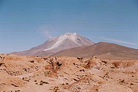
Wanaku (Quechua for guanaco,[2] Hispanicized spelling Huanaco, Huanacu) is a mountain in the Andes of Bolivia, about 4,700 metres (15,420 ft) high. It is situated in the Potosí Department, Nor Lípez Province, Quemes Municipality, Pelcoya Canton. Wanaku lies southeast of the Ollagüe (Ullawi) volcano and northeast of Ch'aska Urqu.[3]
References[]
- ^ "South America Maps". Joint Operations Graphic. Retrieved August 14, 2014.
- ^ Teofilo Laime Ajacopa (2007). Diccionario Bilingüe Iskay simipi yuyayk’anch [Quechua-English dictionary] (PDF). La Paz, Bolivia.
- ^ "San Pedro de Quemes". Retrieved August 14, 2014.
Capital: Potosí | ||
| Provinces |  | |
| Municipalities (and seats) |
| |
Categories:
- Mountains of Potosí Department
- Potosí Department geography stubs