Wellesley, Massachusetts
Wellesley, Massachusetts | |
|---|---|
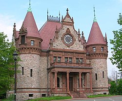 Wellesley Town Hall | |
 Seal | |
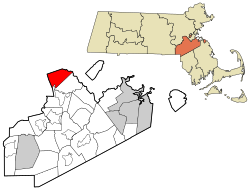 Location of Wellesley in Norfolk County, Massachusetts | |
 Wellesley Location in Massachusetts | |
| Coordinates: 42°17′47″N 71°17′35″W / 42.29639°N 71.29306°WCoordinates: 42°17′47″N 71°17′35″W / 42.29639°N 71.29306°W | |
| Country | |
| State | |
| County | |
| Settled | 1660 |
| Incorporated | 1881 |
| Government | |
| • Type | Representative town meeting |
| • Select Board | show
List of Select Board members |
| Area | |
| • Total | 10.49 sq mi (27.2 km2) |
| • Land | 10.18 sq mi (26.4 km2) |
| • Water | 0.31 sq mi (0.8 km2) |
| Elevation | 141 ft (43 m) |
| Population (2010)[3] | |
| • Total | 27,982 |
| • Density | 2,700/sq mi (1,000/km2) |
| Time zone | UTC−5 (Eastern) |
| • Summer (DST) | UTC−4 (Eastern) |
| ZIP Codes | 02481, 02482, 02457 |
| Area code(s) | 339/781 |
| FIPS code | 25-74175 |
| GNIS feature ID | 0618332 |
| Website | www.wellesleyma.gov |

Wellesley /ˈwɛlzli/ is a town in Norfolk County, Massachusetts, United States. Wellesley is part of Greater Boston. The population was 27,982 at the time of the 2010 census.[3] Wellesley College, Babson College, and a campus of Massachusetts Bay Community College are located in Wellesley.
History[]
Wellesley was settled in the 1630s as part of Dedham, Massachusetts. It was subsequently a part of Needham, Massachusetts called West Needham, Massachusetts. On October 23, 1880, West Needham residents voted to secede from Needham, and the town of Wellesley was later christened by the Massachusetts legislature on April 6, 1881. The town was named after the estate of local benefactor Horatio Hollis Hunnewell.[4][5]
Wellesley's population grew by over 80 percent during the 1920s.[6]
Historic district[]
The town designated Cottage Street and its nearby alleys as the historic district in its zoning plan. Most houses in this district were built around the 1860s and qualify as protected buildings certified by the town's historic commission.
Geography[]
Wellesley is located in eastern Massachusetts. It is bordered on the east by Newton, on the north by Weston, on the south by Needham and Dover and on the west by Natick. According to the United States Census Bureau, the town has a total area of 10.49 square miles (27.2 km2), of which 10.18 square miles (26.4 km2) is land and 0.32 square miles (0.83 km2) is water.[2]
Neighborhoods[]
Recent construction[]
The town's historic 19th-century inn was demolished to make way for condominiums and mixed-use development in 2006.[11] The Wellesley Country Club clubhouse, which is the building where the town was founded, was demolished in 2008, and a new clubhouse was built.[4] The town's pre-World War II high school building was torn down and replaced with a brand new high school finished in 2012.[12] The entire 1960s-style Linden Street strip-mall has been replaced by "Linden Square" – a shopping district that includes a flagship Roche Bros. supermarket, restaurants, cafes, clothing stores, along with a mixture of national chains and local shops.[13]
Demographics[]
| Year | Pop. | ±% |
|---|---|---|
| 1890 | 3,600 | — |
| 1900 | 5,072 | +40.9% |
| 1910 | 5,413 | +6.7% |
| 1920 | 6,224 | +15.0% |
| 1930 | 11,439 | +83.8% |
| 1940 | 15,127 | +32.2% |
| 1950 | 20,549 | +35.8% |
| 1960 | 26,071 | +26.9% |
| 1970 | 28,051 | +7.6% |
| 1980 | 27,209 | −3.0% |
| 1990 | 26,615 | −2.2% |
| 2000 | 26,613 | −0.0% |
| 2010 | 27,982 | +5.1% |
| * = population estimate. Source: United States Census records and Population Estimates Program data.[14][15][16][17][18][19][20] | ||
The Census Bureau has also defined the town as a census-designated place with an area exactly equivalent to the town.[2]
As of the census of 2000, there were 26,613 people, 8,594 households, and 6,540 families residing in the town. The population density was 2,614.1 people per square mile (1,009.4/km2). There were 8,861 housing units at an average density of 870.4 per square mile (336.1/km2). According to a 2007 Census Bureau estimate, the racial makeup of the town was 84.6% White, 10.0% Asian, 2.2% Black, 0.01% Native American, 0.01% Pacific Islander, 1.4% from other races, and 1.7% from two or more races. Hispanic or Latino of any race were 3.4% of the population.[2]
There were 8,594 households, out of which 39.9% had children under the age of 18 living with them, 67.2% were married couples living together, 7.1% had a female householder with no husband present, and 23.9% were non-families. 20.7% of all households were made up of individuals, and 10.5% had someone living alone who was 65 years of age or older. The average household size was 2.70 and the average family size was 3.14.[2]
In the town, the population was spread out, with 25.1% under the age of 18, 13.9% from 18 to 24, 22.9% from 25 to 44, 24.2% from 45 to 64, and 13.9% who were 65 years of age or older. The median age was 38 years. For every 100 females, there were 77.9 males. For every 100 females age 18 and over, there were 71.1 males.[2]
The median income for a household was $159,167, and the median income for a family was $186,518. The per capita income in the town was $72,046.[21] About 2.4% of families and 3.8% of the population were below the poverty line, including 4.0% of those under age 18 and 2.1% of those age 65 or over.[2]
Government[]
This section needs additional citations for verification. (January 2018) |


The town government has been run by town meeting since the town's founding. Since Proposition 2½ limited property tax increases to 2.5% per year in 1980, the town has had to ask residents for a number of overrides to maintain funding for certain programs. Although the main 2005 override passed, a simultaneous supplemental override to preserve certain specific programs and services failed by 17 votes. The 2006 override passed with a large majority. Wellesley also receives funding from the state government. Local roads have been repaved several times in the 1990s and 2000s.
The town is part of the Massachusetts Senate's Norfolk, Bristol and Middlesex district.
Wellesley opened its new Free Library building in 2003, which is part of the Minuteman Library Network. Due to the structure of budget override votes and perhaps the size of the new main branch of the library, the two branch libraries—one in Wellesley Hills, which was purpose-built to be a branch library in the 1920s, another in Wellesley Fells—closed in the summer of 2006. The branch libraries reopened in September 2008.[22]
On December 18, 2014, Wellesley College and the Town of Wellesley announced that the College's Board of Trustees had chosen the town's $35-million bid for the purchase of 46 acres of land adjacent to its campus. Under this agreement, at least 50% of the North 40 property will be preserved in perpetuity as open space. A special town meeting in January 2015 resulted in a near-unanimous vote in favor of the purchase, and in March 2015, 80 percent of residents that cast votes at the Town election, voted to approve the purchase.
Municipal light plant[]
Wellesley is serviced by the Wellesley Municipal Light Plant (WMLP). It is one of only a handful of municipal light plants in the state of Massachusetts.
Recycling and disposal facility[]
There is no residential trash pickup in Wellesley. Instead, residents cart their own refuse to Wellesley's Recycling and Disposal Facility (RDF), a town-operated multi-use waste recycling site, where items are sorted by type, recyclability, and potential reuse. Old books and magazines are available for town residents to take, which have their own shelving section.
The RDF also has a "Take it or Leave it" area where residents leave items they no longer want but that are in good repair. In 2004, the Town had to discontinue the "Take it or Leave it" because of funding cutbacks. However, within six months town residents reinstated it by means of a volunteer system. The section reopened with volunteers on duty at all times to organize the goods and ensure that only usable items were left there.
Education[]

The following year,[when?] the high school's accreditation was placed on warning status by the New England Association of Schools and Colleges Commission on Public Secondary Schools.[23] Wellesley High gained national attention in 2012 when English teacher David McCullough Jr. (son of noted author and historian David McCullough) delivered a widely read and viewed commencement address dubbed "You're Not Special", in which he urged graduates not to take things for granted.
On the Massachusetts Comprehensive Assessment System test, the district regularly scores higher than the state average.[24][25][26] The school system also contains a middle school and seven elementary schools (Bates, Upham, Schofield, Fiske, Hardy, Hunnewell, and Sprague).[citation needed]
The town contains a private elementary school, Tenacre Country Day School, one private Catholic elementary school (St. John the Evangelist) and a preparatory school for girls, Dana Hall School. Also, the Wellesley A Better Chance outfit started in the early 1970s brings promising young women from underserved areas into town to attend Wellesley High School and live nearby.[27]
Wellesley also contains the main campus of three colleges: Wellesley College, a women's liberal arts college, Massachusetts Bay Community College, a two-year public college, and Babson, a business college.[citation needed]
Transportation[]

Wellesley has had rail service to Boston since 1833. Rail service is currently provided through Wellesley's participation in the MBTA, which offers a total of 17 weekdays Commuter Rail trains inbound towards Boston and outbound towards Framingham and Worcester. Wellesley's stations are (east to west) Wellesley Farms, Wellesley Hills, and Wellesley Square. The Wellesley Farms station is listed on the U.S. National Register of Historic Places. MWRTA bus service also runs along Walnut Street, Cedar Street, and Route 9.
The highways Interstate 95/Massachusetts Route 128, Massachusetts Route 9, Massachusetts route 16 and Massachusetts route 135 run through Wellesley.
For elders and people with disabilities there is a specific MBTA-based service, The Ride, which offers free or low-cost door-to-door service by appointment.[28]
From nearby Riverside MBTA Station in Newton, commuter express buses run to downtown Boston, Newton Corner and Central Square, Waltham. This is also a station for Greyhound Lines and Peter Pan Bus Lines with frequent service to Boston, New York City, and other destinations.
Wellesley's Council on Aging contracts out a daily low-cost minibus service offering elderly access to several local medical facilities and the Woodland MBTA station.[29] Further afield is the Springwell Senior Medical Escort Program / Busy Bee Transportation Service for rides to medical & non-medical services in the area. There is also a monthly minibus to the Natick Mall.
For Amtrak service the nearest stations are west in Framingham, east in Boston at Back Bay and South Station, and south in Route 128 Station in Westwood.
Those affiliated with Wellesley College can take advantage of their bus services to Cambridge and Needham.[30] Wellesley College and Babson College also both offer discounted Zipcar service.[31][32]
The nearest international airport is Boston Logan Airport, 18 miles from Wellesley.
Sustainability[]
This section needs additional citations for verification. (January 2018) |
Green Power Community[]
In February 2009 Wellesley's municipal light plant introduced the "POWER TO CHOOSE" program to improve home efficiency and offer a variety of options for the community to lower energy consumption. As a result, many residents, businesses, and the three colleges voluntarily pay a premium to purchase electricity generated by wind power.
In 2012, Wellesley was designated a Green Power Community by the United States Environmental Protection Agency, the only Green Power Community in Massachusetts and the second in all of New England.[33]
Reducing carbon footprint[]
In 2009 the town established the Municipal Energy Efficiency Committee (MEEC) made up of representatives from various town departments, to develop and evaluate municipal policies to reduce energy use.
In 2010 Wellesley's Sustainable Energy Committee (SEC) was formed by Town Meeting. The committee's primary objective was a 10% town-wide reduction in Wellesley's carbon footprint and 20% reduction in carbon footprint for all municipal departments by the end of 2013. In 2014 Town Meeting voted to support a new goal of 25% reduction by 2020 using 2007 as the base year. The committee is responsible for Wellesley's adoption of the Massachusetts Stretch Building Code approved by Town Meeting effective January 2012.[34]
In 2013, the committee organized Wellesley's Green Collaborative, a group of organizations that are concerned about environmental issues in Wellesley and beyond. Dozens of like-minded organizations are represented including the Natural Resources Commission, a five-member elected board of town residents; Wellesley Conservation Council, a private, non-profit, land trust and conservation education organization incorporated in 1958; and Sustainable Wellesley, a group of volunteers who encourage sustainability in Wellesley and the surrounding area through events, education, and action.
In 2014 the Sustainable Energy Committee served to double participation in the town's POWER TO CHOOSE program and organized the "More POWER TO CHOOSE" solar program.
Natural resources protection[]
Wellesley is the longest running Tree City USA community of any city or town in Massachusetts. Wellesley's Tree Bylaw became effective July 1, 2011, requiring property owners to protect certain trees and critical root zones during construction projects, and replace trees that are cut down or donate money to a special tree fund. The town's Natural Resource Protection (NRP) Development bylaw, approved by Town Meeting in 2013, applies to any subdivision generating five or more lots. This bylaw requires a minimum of 50% of the property be preserved as open space in exchange for reduced lot sizes without increasing density.[citation needed]
Established in 1979, Wellesley has a unique elected Natural Resources Commission (NRC) bearing the statutory authority and responsibility of Park Commissions, Conservation Commissions, Tree Wardens, Town Forest Committees, and Forestry and Pest Control Officers. The commission maintains Wellesley's two Community Gardens and maintains a trail network that includes 26 miles of marked trails interconnecting open spaces and conservation lands for walking, dog walking, jogging, bicycling, cross-country skiing, and more.
In 2001 the commission, in collaboration with the Health, Public Works and School department, developed a pesticide awareness program resulting in an Organic Pest Management Policy governing pesticide use on all town-owned property.
In 2003 the commission created the Preservation Master Plan for Fuller Brook Park in collaboration with Wellesley's Department of Public Works. This major restoration project was completed in 2017. In 2009, the commission launched the Green Wellesley Campaign advocating for sustainability by raising awareness and promoting increased environmental action. That campaign has been renamed the Grow Green Wellesley initiative, which promotes earth-friendly lawn and landscaping practices.[citation needed]
Green Schools[]
Wellesley Green Schools was established in 2006. Their No Idling Campaign received anExcellence in Energy and Environmental Education Award from the state of Massachusetts in 2014.
The town's new high school opened in February 2012 and includes such elements as green vegetated roof, geothermal heat pump and Solar thermal cooling, Solar Photovoltaic system, and rainwater recovery systems.[citation needed]
Waste management[]
In 2015 the Wellesley 3R (Reduce/Reuse/Recycle) Working Group was formed to consider possible initiatives to increase recycling and reduce waste in Wellesley. The initiative is a joint-effort of the Department of Public Works, Natural Resources Commission and Sustainable Energy Committee.
Economy[]
This section does not cite any sources. (January 2018) |
Wellesley is home to the headquarters of many local, national and global businesses including Benchmark Senior Living, Blank Label Apparel, Eagle Investment Systems, EPG Incorporated, GrandBanks Capital, Harvard Pilgrim Health Care, Livingston and Haynes PC, Roche Bros., and Sun Life Financial U.S.
- Top employers
According to Wellesley's 2018 Comprehensive Annual Financial Report,[35] the top employers in the city are:
| # | Employer | # of employees |
|---|---|---|
| 1 | Wellesley College | 1,103 |
| 2 | Sun Life Financial | 1,035 |
| 3 | Babson College | 800 |
| 4 | Harvard Pilgrim Health Care | 446 |
| 5 | Harvard Vanguard Medical Associates | 350 |
| 6 | Massachusetts Bay Community College | 295 |
| 7 | Whole Foods Market | 292 |
| 8 | Wellesley Country Club | 265 |
| 9 | Roche Bros. | 260 |
| 10 | Dana Hall School | 214 |
Culture[]
Wellesley's Wonderful Weekend[]
Each year the weekend before Memorial Day, the town sponsors the annual Wellesley's Wonderful Weekend, which includes the annual veterans' parade and fireworks. On May 18, 2008, The Beach Boys performed in a concert on the Wellesley High School athletic fields in front of an estimated 10,000 town residents and fans. The funds for the performance, an estimated $250,000, were made as a gift by an anonymous donor and lifelong fan of the band.
Wellesley Symphony Orchestra[]
The Wellesley Symphony Orchestra presents classical, pops, and family concerts at Mass Bay Community College at its Wellesley campus.
Religious institutions[]
The town of Wellesley is home to several religious institutions. Wellesley contains two Jewish institutions including Temple Beth Elohim and the Wellesley Chabad Center. Predominantly Christan Wellesley contains many churches, including Wellesley Congregational Church, St. Andrew's Episcopal Church, St. Paul's Catholic Church, Christ Church United Methodist, Wellesley Hills Congregational Church (also known as The Hills Church), First Church of Christ-Scientist, St. John the Evangelist Catholic Church, the Metrowest Baptist Church, Milestone Wellesley, and Unitarian Universalist Society of Wellesley Hills, and Wellesley Friends Meeting (Quakers).
Horticulture[]
The Wellesley College campus includes greenhouses and the H. H. Hunnewell Arboretum. This is not to be confused with the neighboring private H. H. Hunnewell estate. The Elm Bank Horticulture Center is home to the Massachusetts Horticultural Society. Although the entrance is in Wellesley, access is over a small private bridge over the Charles River, so Elm Bank is therefore in the neighboring town of Dover.
Media[]
Events of significance to members of the Wellesley community are recorded in two local news publications: The Wellesley Townsman[36] has been published since 1906, and The Swellesley Report since 2005. Both are available online and digitized copies of the paper-based Townsman are available from the Wellesley Free Library.
Notable people[]


- Danny Ainge, executive director of basketball operations and general manager of the Boston Celtics
- Roger Nash Baldwin, co-founder of American Civil Liberties Union
- Arthur Batcheller, U.S. radio inspector
- Katharine Lee Bates, author of America the Beautiful[37]
- Gamaliel Bradford, poet, biographer
- Dee Brown, former basketball player for the Boston Celtics
- Laurence E. Bunker, United States Army colonel, aide to Gen. Douglas MacArthur, leader within the John Birch Society
- R. Nicholas Burns, former U.S. Under Secretary of State, Ambassador to NATO and to Greece, and State Department spokesman
- Karl E. Case, developer of the Case–Shiller index
- Dan Chiasson, poet and New Yorker critic
- Katharine Coman, historian, professor of economics and sociology, author
- Greg Comella, former professional football player with the New York Giants, Titans, Texans and Buccaneers
- Jane Curtin, comedian, original cast member of Saturday Night Live
- Richard Darman, economist, former head of the Office of Management and Budget
- Erik Davis (baseball), former pitcher for the Washington Nationals
- Blake Dietrick, WNBA basketball player with the Seattle Storm and former standout with the Princeton Tigers
- Dennis Eckersley, former pitcher for the Oakland A's
- Carl Everett, former center fielder for the Boston Red Sox
- Nicole Freedman (born 1972), Olympic cyclist
- Nate Freiman (born 1986), first baseman for the Oakland Athletics
- Wendell Arthur Garrity Jr., U.S. District Court judge
- Curt Gowdy, sports commentator
- Michael S. Greco, President of American, Massachusetts & New England bar associations
- Gordon Hayward, small forward for the Boston Celtics
- H. H. Hunnewell (1810-1902), railroad financier and horticulturist
- Andrea Jung, CEO of Avon Products
- Phil Laak, professional poker player, winner of 2004 World Poker Tour
- Xihong Lin, Department of Biostatistics chair at the Harvard School of Public Health
- Gregory Mankiw, Harvard economics professor
- Daisuke Matsuzaka, former pitcher for the Boston Red Sox
- Fred McLafferty, professor, analytical chemist, author, inventor, leading developer of mass spectrometry
- Drew Meekins, figure skater
- Ossian Everett Mills, founder of Phi Mu Alpha Sinfonia fraternity
- Brian Moynihan, CEO of Bank of America
- Bill Mueller, former third baseman for the Boston Red Sox
- Joseph E. Murray, surgeon, winner of the Nobel Prize in Medicine, 1990
- Vladimir Nabokov, Russian-American author
- Joe Nash, retired NFL player for the Seattle Seahawks
- Sylvia Plath, poet and author, The Bell Jar
- Richard Preston and Douglas Preston, best-selling authors
- Aneesh Raman, former presidential speechwriter at the White House and CNN Middle East Correspondent
- James St. Clair, defense lawyer for Richard Nixon during Watergate
- Edward Thomas Ryan, president, American Society of Tropical Medicine and Hygiene; professor, Harvard University
- Jack Sanford, former MLB pitcher, 1957 MLB Rookie of the Year Award recipient
- Billy Squier, rock musician
- Brad Stevens, head coach of the Boston Celtics
- Biz Stone, Twitter co-founder
- Steven Tyler, rock musician, lived in Wellesley during the late 1990s and early 2000s
- Michael von Clemm, banker, anthropologist and founder of Canary Wharf
- Rasheed Wallace, retired professional basketball player
- Johnny Angel Wendell, radio host, author and musician
- Greg Yaitanes, Emmy Award-winning film director, writer, actor
- Eddie Yost, baseball player and coach[38]
References[]
- ^ "Wellesley Board of Selectmen".
- ^ Jump up to: a b c d e f g "U.S. Census website". United States Census Bureau. Retrieved January 31, 2008.
- ^ Jump up to: a b "Population and Housing Occupancy Status: 2010 – State – County Subdivision, 2010 Census Redistricting Data (Public Law 94-171) Summary File". U.S. Census Bureau. Retrieved July 10, 2011.[dead link]
- ^ Jump up to: a b Smolski, Anne-Marie (October 26, 2009). "Monument marks birthplace of Wellesley". The Wellesley Townsman. Retrieved March 14, 2010.
- ^ Hinchliffe, Beth. "History of Wellesley". Retrieved July 17, 2021.
- ^ Schaeffer, K. H.; Sclar, Elliott (1980). Access for All: Transportation and Urban Growth. Columbia University Press. ISBN 0-231-05165-4. Retrieved January 16, 2010.
- ^ Jump up to: a b c d e f g h Shulkin, Traci. "WELLESLEY NEIGHBORHOODS". The Traci Shulkin Group. Retrieved August 29, 2020.
- ^ "Zip Code 02481, Wellesley Hills, MA". Zip-codes.com. Retrieved August 29, 2020.
- ^ "Zip Code 02482, Wellesley, MA". Zip-codes.com. Retrieved August 29, 2020.
- ^ "ZIP Code 02457". Zipcodes.org. Retrieved August 29, 2020.
- ^ Lehmann, Barbara (March 29, 2006). "No rooms at the inn". The Wellesley Townsman. Retrieved March 14, 2010.
- ^ Zak, Elana (September 4, 2009). "Wellesley High School project moving ahead". The Wellesley Townsman. Retrieved March 14, 2010.
- ^ Lebeaux, Rachel (March 29, 2006). "Design Review approves Linden Street plan". The Wellesley Townsman. Retrieved March 14, 2010.
- ^ "TOTAL POPULATION (P1), 2010 Census Summary File 1, All County Subdivisions within Massachusetts". United States Census Bureau. Archived from the original on February 12, 2020. Retrieved September 13, 2011.
- ^ "Massachusetts by Place and County Subdivision – GCT-T1. Population Estimates". United States Census Bureau. Archived from the original on February 12, 2020. Retrieved July 12, 2011.
- ^ "1990 Census of Population, General Population Characteristics: Massachusetts" (PDF). US Census Bureau. December 1990. Table 76: General Characteristics of Persons, Households, and Families: 1990. 1990 CP-1-23. Retrieved July 12, 2011.
- ^ "1980 Census of the Population, Number of Inhabitants: Massachusetts" (PDF). US Census Bureau. December 1981. Table 4. Populations of County Subdivisions: 1960 to 1980. PC80-1-A23. Retrieved July 12, 2011.
- ^ "1950 Census of Population" (PDF). 1: Number of Inhabitants. Bureau of the Census. 1952. Section 6, Pages 21–10 and 21–11, Massachusetts Table 6. Population of Counties by Minor Civil Divisions: 1930 to 1950. Retrieved July 12, 2011. Cite journal requires
|journal=(help) - ^ "1920 Census of Population" (PDF). Bureau of the Census. Number of Inhabitants, by Counties and Minor Civil Divisions. Pages 21–5 through 21–7. Massachusetts Table 2. Population of Counties by Minor Civil Divisions: 1900, 1910, and 1920. Retrieved July 12, 2011.
- ^ "1890 Census of the Population" (PDF). Department of the Interior, Census Office. Pages 179 through 182. Massachusetts Table 5. Population of States and Territories by Minor Civil Divisions: 1880 and 1890. Retrieved July 12, 2011.
- ^ Massachusetts locations by per capita income
- ^ "Branch Libraries reopen this week". The Wellesley Townsman. September 4, 2008. Retrieved March 14, 2010.
- ^ "WHS placed on warning". Wellesley Townsman. November 19, 2008.
- ^ "2007 MCAS Results – Wellesley Public Schools". The Boston Globe. 2007. Retrieved March 14, 2010.
- ^ "2008 MCAS Results – Wellesley Public Schools". The Boston Globe. September 23, 2008. Retrieved March 14, 2010.
- ^ "2009 MCAS Results – Wellesley Public Schools". The Boston Globe. September 14, 2009. Retrieved March 14, 2010.
- ^ http://theswellesleyreport.com/2012/11/wellesley-a-better-chance-celebrates-40-years-of-helping-young-women-thrive
- ^ "The Ride Guide". Retrieved February 25, 2010.
- ^ "Town of Wellesley, Massachusetts – Transportation". Retrieved February 24, 2010.
- ^ "Wellesley College Transportation". Retrieved February 24, 2010.
- ^ "Zipcar: Organizations: Wellesley". Retrieved February 24, 2010.
- ^ "Zipcar: Organizations: Babson". Retrieved February 24, 2010.
- ^ [theswellesleyreport.com/2019/06/wellesley-stands-mighty-with-its-36th-consecutive-tree-city-designation/ "Wellesley Stands Mighty with Its 36th Consecutive Tree City Designation"] Check
|url=value (help). Retrieved March 3, 2021. - ^ "Sustainable Energy Committee: Wellesley, MA". Retrieved March 3, 2021.
- ^ City of Wellesley CAFR
- ^ "The Wellesley Townsman". Wellesley Free Library. Retrieved March 28, 2018.
- ^ Google Books: Yellow Clover: A Book of Remembrance, (E.P. Dutton, 1922), quote viii, accessed January 6, 2012
- ^ Eddie Yost at SABR Baseball Biography Project
External links[]
| Wikivoyage has a travel guide for Wellesley, Massachusetts. |
| Wikimedia Commons has media related to Wellesley, Massachusetts. |
| Wikisource has the text of the 1911 Encyclopædia Britannica article Wellesley. |
| show Municipalities and communities of Norfolk County, Massachusetts, United States |
|---|


| show Authority control |
|---|
- Wellesley, Massachusetts
- Towns in Norfolk County, Massachusetts
- Populated places established in 1660
- 1660 establishments in Massachusetts
- Populated places established in 1881
- Towns in Massachusetts