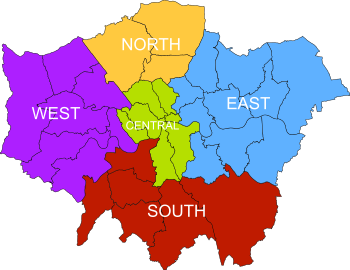
West London

West London refers to the western part of London, England, bordered by Surrey to the west, south west, and south; Berkshire to the west and north west; Buckinghamshire to the north west; and Hertfordshire to the north. A publication by the Mayor of London in 2011 referred to the London boroughs of Brent, Harrow, Ealing, Hammersmith and Fulham, Hounslow, Richmond, and Hillingdon as West London. Although commonly considered to be part of Central London, sometimes Westminster and all areas westwards are referred to as West London. The Royal Borough of Kingston upon Thames, in south west London, is variably considered part of West London or South London.
The term is used to differentiate the area from the other parts of London, North London, East London and South London.[1]
Economy[]
London Plan[]
The London Plan[2] defines two areas of London as International Centres, the West End and Knightsbridge, both in west London. Five of the thirteen Metropolitan Centres in the plan are also in West London: Ealing, Hounslow, Harrow, Uxbridge and Shepherd's Bush.
Eleven of the London Plan's thirty-eight Opportunity Areas are part of West London; Kensal Canalside, Paddington, Earl's Court and West Kensington, Harrow and Wealdstone, Park Royal, Old Oak Common, Southall, Tottenham Court Road, Victoria, Wembley and White City.
Major employers[]
London Heathrow Airport is a major employer in West London, and the University of West London has more than 47,000 students.[3]
Emergence[]
The development of the area began with the establishment of the Abbey on a site then called Thorney Island, the choice of site may in part relate to the natural ford which is thought to have carried Watling Street over the Thames in the vicinity.[4] Tradition dates the foundation to the 7th Century AD with written records dating back to the 960s or early 970s.[5] The Island and surrounding area became known as Westminster in reference to the church.
The legendary origin[6] is that in the early 7th century, a local fisherman named Edric, ferried a stranger in tattered foreign clothing over the Thames to Thorney Island. It was a miraculous appearance of St Peter, a fisherman himself, coming to the island to consecrate the newly built church, which would subsequently develop into Westminster Abbey. He rewarded Edric with a bountiful catch when he next dropped his nets. Edric was instructed to present the King and St. Mellitus, Bishop of London with a salmon and various proofs that the consecration had already occurred . Every year on 29 June, St Peters day, the Worshipful Company of Fishmongers presents the Abbey with a salmon in memory of this event.[7]
The Palace of Westminster subsequently developed, with Parliament being based there from its establishment in 1265. The presence of the centre of government as a distinct focus for growth, accompanied by the proximity of the City, ensured that western London was the fastest growing part of early London.
In 1720, John Strype's 'Survey of London' described Westminster as one of the then four distinct areas of London;[8] in it he describes the City of London, Westminster (West London), Southwark (South London), and 'That Part beyond the Tower' (East London). The area now usually referred to as North London developed later.

As well as the proximity of the centre of government, the West End was long favoured by the rich elite as a place of residence because it was usually upwind of the smoke drifting from the crowded City.[9] A further factor facilitating rapid growth in West London was the very large number of bridges linking the area to South London and the area beyond; by contrast, even today, there are no bridges east of Tower Bridge, partly as the river becomes wider as it heads east.
Like other areas of the capital, West London grew rapidly in the Victorian era as a result of railway-based commuting; with the building of the termini at Paddington and Marylebone, and the lines radiating from them, having a particularly profound effect. This trend continued in the twentieth century and was subsequently reinforced by motorcar-based commuting.
The size of London stabilised after the establishment of the Metropolitan Green Belt shortly after the Second World War.
Official designations[]
The term 'West London' has been used for a variety of formal purposes with the boundaries defined according to the purposes of the designation.
Planning Policy sub-region[]
The 2011 iteration of the London Plan[10] included an altered 'West' sub-region, to be used for planning, engagement, resource allocation and progress reporting purposes. It consists of the London Boroughs of Brent, Harrow, Ealing, Hammersmith and Fulham, Hillingdon, Hounslow and the Richmond upon Thames. As well as including outer areas of West London, the sub-region also includes areas south of the river, not usually counted as part of West London; areas of the cross-river London Borough of Richmond upon Thames.
The 2004-2008 and 2008-2011 versions of the sub-region varied in their composition.
W postcode area[]
The W (Western) postcode area was introduced in 1857[11] to facilitate the distribution of mail. The postcode area is a sub-set of West London in some definitions or the extent of West London in others, since it does not include areas frequently counted as part of North West London.
Many areas with a SW postcode are in fact in West London and are north of the river, such as Chelsea and South Kensington.
See also[]
References[]
- ^ Blundy, Rachel (27 January 2014). "'East is poor, West is posh, South is rough and North is 'intellectual': Londoners' views on the city's postcodes revealed". Evening Standard.
- ^ "The London Plan". London City Hall. 11 November 2015.
- ^ "The economic impact of the University of West London" (PDF; 850 MB). UWL.ac.uk. University of West London / . May 2013. Retrieved 3 October 2017.
- ^ "Loftie's Historic London (review)". The Saturday Review of Politics, Literature, Science and Art. 63 (1, 634): 271. 19 February 1887. Retrieved 21 October 2015.
- ^ Page, William (1909). "'Benedictine monks: St Peter's abbey, Westminster', in A History of the County of London: Volume 1, London Within the Bars, Westminster and Southwark". London. pp. 433–457. Retrieved 28 July 2018.
- ^ Robert Turner (January 2015). "The Tale of a Fish How Westminster Abbey became a Royal Peculiar" (PDF). Choir Schools' Association. Retrieved 23 September 2021.
- ^ pixeltocode.uk, PixelToCode. "Fishmongers' Company". Westminster Abbey.
- ^ "John Strype's Survey of London Online". www.dhi.ac.uk.
- ^ Robert O. Bucholz and Joseph P. Ward: London: A Social and Cultural History, 1550–1750. Cambridge: Cambridge University Press 2012, p. 333
- ^ London City Hall. "Policy 2.5 Sub-regions"..
- ^ "Postcodes". The Postal Museum.
- Geography of London