London Borough of Brent
London Borough of Brent | |
|---|---|
| Motto(s): Forward Together | |
 Brent shown within Greater London | |
| Sovereign state | United Kingdom |
| Constituent country | England |
| Region | London |
| Ceremonial county | Greater London |
| Historic county | Middlesex |
| Created | 1 April 1965 |
| Admin HQ | Engineers Way, Wembley |
| Government | |
| • Type | London borough council |
| • Body | Brent London Borough Council |
| • Leader | Muhammed Butt (Labour) |
| • Mayor | Lia Colacicco [1] |
| • London Assembly | Krupesh Hirani (Lab) AM for Brent and Harrow |
| • MPs | Barry Gardiner (Lab) Tulip Siddiq (Lab) Dawn Butler (Lab) |
| Area | |
| • Total | 16.70 sq mi (43.24 km2) |
| Area rank | 276th (of 309) |
| Population (mid-2019 est.) | |
| • Total | 329,771 |
| • Rank | 28th (of 309) |
| • Density | 20,000/sq mi (7,600/km2) |
| • Ethnicity[2] | 18% White British 4% White Irish 0.1% White Gypsy or Irish Traveller 14.3% Other White 1.4% White & Black Caribbean 0.9% White & Black African 1.2% White & Asian 1.6% Other Mixed 18.6% Indian 4.6% Pakistani 0.6% Bangladeshi 1% Chinese 9.2% Other Asian 7.8% Black African 7.6% Black Caribbean 3.4% Other Black 3.7% Arab 2.1% Other |
| Time zone | UTC (GMT) |
| • Summer (DST) | UTC+1 (BST) |
| Postcodes | |
| Area code(s) | 020 |
| ONS code | 00AE |
| GSS code | E09000005 |
| Police | Metropolitan Police |
| Website | http://www.brent.gov.uk |

The London Borough of Brent (![]() pronunciation (help·info)) is a London borough in north-west London. It borders the boroughs of Harrow to the north-west, Barnet to the north-east, Camden to the east, the City of Westminster to the south-east, as well as the Royal Borough of Kensington and Chelsea, Hammersmith and Fulham and Ealing to the south. Most of the eastern border is formed by the Roman road Watling Street, which is now the modern A5.
pronunciation (help·info)) is a London borough in north-west London. It borders the boroughs of Harrow to the north-west, Barnet to the north-east, Camden to the east, the City of Westminster to the south-east, as well as the Royal Borough of Kensington and Chelsea, Hammersmith and Fulham and Ealing to the south. Most of the eastern border is formed by the Roman road Watling Street, which is now the modern A5.
Brent's population is estimated to be 329,771. Major districts are Kilburn, Willesden and Wembley, while other districts include Harlesden, Stonebridge, Kingsbury and Queen's Park. Brent has a mixture of residential, industrial and commercial land. It includes many districts of inner-city character in the east and a more distinct suburban character in the west, part of which formed part of the early 20th century Metroland developments. Today Brent is known for being home to Wembley Stadium, the country's largest stadium by capacity, as well as other landmarks such as the Kiln Theatre, the Swaminarayan Temple and Wembley Arena. Other notable places are the Welsh Harp reservoir and the Park Royal commercial estate. The local authority is Brent London Borough Council.
Local government[]
Administrative history[]
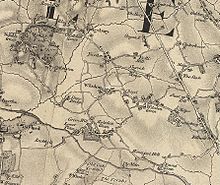
Brent was formed in 1965 from the area of the former Municipal Borough of Wembley and Municipal Borough of Willesden of Middlesex. The Municipal Borough of Wembley was formed by a merger of the parishes of Wembley (originally part of the Ancient Parish of Harrow-on-the-Hill) and Kingsbury.
Its name derives from the River Brent which runs through the borough and separated the former boroughs of Wembley and Willesden.[3]
Representation[]
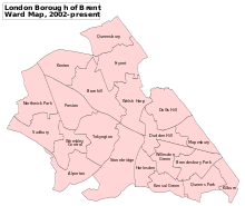
Brent is divided into 21 electoral wards. Some wards share a name with the traditional areas above, others include Mapesbury and Welsh Harp.[4]
The borough includes three parliamentary constituencies: Brent North, Brent Central and Hampstead and Kilburn, which includes part of the London Borough of Camden. Before the 2010 United Kingdom general election it was divided into three constituencies contained wholly within the borough - Brent South, Brent East and Brent North.
Politics[]
Brent London Borough Council is elected every four years, with currently 63 councillors being elected at each election. While the Labour Party has been the largest single party on the council for about half its history and the Conservatives and the Liberal Democrats have each been the largest party at other times, there have been several periods when no party has had overall control. Labour regained control in 2010 and increased their majority at the 2014 election and 2018 election. As of 2020, the council is composed of the following councillors:[5][6]
| Party | Councillors | |
| Labour Party | 59 | |
| Conservative Party | 3 | |
| Liberal Democrats | 1 | |
The Leader of the council is Labour Councillor Muhammed Butt.[7]
Proposals to partition the borough[]
The merger of Willesden and Wembley (including Kingsbury) in 1965 created the borough of Brent, but this was one of the more unpopular of the mergers occurring during the creation of the modern London boroughs.[citation needed] Reasons for this included the limited road links between the two areas (with the A4088 and A404 Harrow Road, the only major road links across the Brent valley boundary), the lack of a focal point or ‘heart’ for the borough and the contrasting characteristics; with Willesden more inner-city in nature, and Wembley more suburban. Widening schemes for the North Circular Road, which passed along the Brent valley, close to the boundary between the two, increased this sense of separation.
The unpopularity persisted and in 1989 more than ten thousand people signed a petition calling for Wembley (with Kingsbury) to regain its independence or else join with the London Borough of Harrow with which it had historic administrative links, had better transport integration and had shared common suburban interests. The 1994, the Boundary Commission considered this, and other requests, considering a wide range of options[8] including restoring independence to the districts, or joining them to different neighbouring boroughs – an option the Commission preferred.[citation needed]
Wembley and Harrow would represent a pre-20th century remerger. The London Borough of Harrow supported the failed idea and that of the eastern boundary's straightening (with the London Borough of Barnet along the A5 Road (Watling Street, Edgware Road)). Willesden was harder to idealise a match with an existing Borough. The Boroughs and Commission, by narrow consensus, saw Ealing as most likely, yet a main bar would remain of the lack of a focal point and the industrial zones of Park Royal, Old Oak Common and North Acton, a busy buffer zone.
The Commission concluded there was insufficient justification for the disruption of the proposals, which should only be considered during a comprehensive review of London's boundaries.
Demographics[]
| Year | Pop. | ±% |
|---|---|---|
| 1801 | 2,022 | — |
| 1811 | 2,690 | +33.0% |
| 1821 | 3,074 | +14.3% |
| 1831 | 3,991 | +29.8% |
| 1841 | 5,416 | +35.7% |
| 1851 | 5,646 | +4.2% |
| 1861 | 14,749 | +161.2% |
| 1871 | 23,852 | +61.7% |
| 1881 | 32,955 | +38.2% |
| 1891 | 67,674 | +105.4% |
| 1901 | 105,613 | +56.1% |
| 1911 | 164,833 | +56.1% |
| 1921 | 202,448 | +22.8% |
| 1931 | 248,656 | +22.8% |
| 1941 | 277,842 | +11.7% |
| 1951 | 310,457 | +11.7% |
| 1961 | 294,804 | −5.0% |
| 1971 | 280,009 | −5.0% |
| 1981 | 251,249 | −10.3% |
| 1991 | 248,569 | −1.1% |
| 2001 | 263,463 | +6.0% |
| 2011 | 311,215 | +18.1% |
| Source: A Vision of Britain through time | ||
In 1801, the civil parishes that form the modern borough had a total population of 2,022. This rose slowly throughout the nineteenth century, as the district became built up; reaching 5,646 in the middle of the century. When the railways arrived the rate of population growth increased. The population took five decades to rebound to the more muted peak of the 1950s, when much industry relocated from London, further boosting the speed of the wave of new housing then built.
Brent is the most diverse locality in the UK by country of birth. It in 2019 became the only local authority with over 50% of residents, namely 52%, born abroad.[9] Large Asian and Indian, Black African, Black Caribbean, Irish, and Eastern European communities exist. 45 percent of the population was a minority ethnicity in the 1991 census,[10] the most in England at the time.[11] In 1991 17.2% were Indian, 10.2% were Black Caribbean and 9% were Irish. Brent was the only Outer London borough combining high proportions of Indian and Afro-Caribbean ethnicities.[12]
The 2001 UK Census found that the borough had a population of 263,464 residents, of whom 127,806 were male, and 135,658 female. Of those stating a choice, 47.71% described themselves as Christian, 17.71% as Hindu, 12.26% as Muslim and 10% as having no religion. Among residents, 39.96% were in full-time employment and 7.86% in part-time employment – compared to a London average of 42.64% and 8.62%, respectively. Narrowly most residents included an owner-occupier in their household, with 23.17% of households owning their house outright, and a further 31.33% owning with a mortgage. 10.59% were in local authority housing, with a further 13.29% renting from a housing association, or other registered social landlord.[13]
The borough of Brent is extremely ethnically diverse, having changed greatly since 1951. In the 2011 census, those who identified as White British made up 18% of the borough's population. 18% identified as other White, 5% were of mixed heritage, those of South Asian heritage comprised about 33%, those of African and Caribbean heritage about 19%, and other ethnic groups about 7%. White ethnicities were relatively high in the wards of Mapesbury (straddling Willesden Green and Cricklewood), Brondesbury Park, Queen's Park and Kilburn. Black ethnicities in highest proportion were in Stonebridge, Harlesden and Kensal Green wards. Asian ethnicities in highest proportion were in the wards of Alperton, Wembley Central and Kenton.[14] Those who ethnically identify as BAME (Black, Asian and minority Ethnic) was as high as 86% in Wembley Central – one of the highest in London – and most other Brent wards have a majority BAME population. Queen's Park had the lowest BAME proportion, at 37.0%.[15]
Brent has the highest proportion of Irish residents in Britain, with 4% of the population.[16] It also has one of the largest Brazilian communities in the UK;[17] one of the largest Indian communities;[18] a significant Afro-Caribbean community;[19] and more recent Romanian, Polish and Somali communities.[20]
Religion[]
As of 2011, 41.5% identified themselves as Christian, 18.6% Muslim, 17.8% Hindu and 10.6% with no religion.[21] Brent is notably home of the Neasden Temple, once the largest Hindu Mandir outside India; and JFS, the largest Jewish school in Europe.[22] There is also an Islamic school called Islamia Primary School founded by Cat Stevens.
Health[]
Per the House of Commons survey of female genital mutilation, in the year to 31 March 2016, Brent represented the highest number of attendees, by current residence or visiting location, to medical services, at 1250, 545 more than the next-highest local authority, Bristol.[23]
In 2015, the BBC reported it was some wards of Brent and four other London Boroughs that had the highest UK rates of tuberculosis (over 150 per 100000) per a high, but falling, situation from 2011 to 2013.[24]
Ethnicity[]
This table shows the stated ethnic group of respondents of the 2001 and 2011 censuses in Brent.
| Ethnic Group | 2001[25] | 2011[26] | ||
|---|---|---|---|---|
| Number | % | Number | % | |
| White: British | 76,893 | 29.19% | 55,887 | 17.96% |
| White: Irish | 18,313 | 6.95% | 12,320 | 3.96% |
| White: Gypsy or Irish Traveller | 320 | 0.10% | ||
| White: Other | 24,072 | 9.14% | 44,353 | 14.25% |
| White: Total | 119,278 | 45.27% | 112,880 | 36.27% |
| Asian or Asian British: Indian | 48,624 | 18.46% | 58,017 | 18.64% |
| Asian or Asian British: Pakistani | 10,626 | 4.03% | 14,381 | 4.62% |
| Asian or Asian British: Bangladeshi | 1,184 | 0.45% | 1,749 | 0.56% |
| Asian or Asian British: Chinese | 2,812 | 1.07% | 3,250 | 1.04% |
| Asian or Asian British: Other Asian | 12,628 | 4.79% | 28,589 | 9.19% |
| Asian or Asian British: Total | 75,874 | 28.80% | 105,986 | 34.06% |
| Black or Black British: African | 20,640 | 7.83% | 24,391 | 7.84% |
| Black or Black British: Caribbean | 27,574 | 10.47% | 23,723 | 7.62% |
| Black or Black British: Other Black | 4,123 | 1.56% | 10,518 | 3.38% |
| Black or Black British: Total | 52,337 | 19.86% | 58,632 | 18.84% |
| Mixed: White and Black Caribbean | 2,739 | 1.04% | 4,291 | 1.38% |
| Mixed: White and Black African | 1,739 | 0.66% | 2,820 | 0.91% |
| Mixed: White and Asian | 2,529 | 0.96% | 3,642 | 1.17% |
| Mixed: Other Mixed | 2,795 | 1.06% | 5,022 | 1.61% |
| Mixed: Total | 9,802 | 3.72% | 15,775 | 5.07% |
| Other: Arab | 11,430 | 3.67% | ||
| Other: Any other ethnic group | 6,512 | 2.09% | ||
| Other: Total | 6,173 | 2.34% | 17,942 | 5.77% |
| Black, Asian, and minority ethnic: Total | 144,186 | 54.73% | 198,335 | 63.73% |
| Total | 263,464 | 100.00% | 311,215 | 100.00% |
Geography[]
Major districts of Brent include: Kilburn, Willesden and Wembley.
Climate[]
Climate in this area has mild differences between highs and lows, and there is adequate rainfall year-round. The Köppen Climate Classification subtype for this climate is "Cfb". (Marine West Coast Climate/Oceanic climate).[27][failed verification]
| hideClimate data for Borough of Brent, UK | |||||||||||||
|---|---|---|---|---|---|---|---|---|---|---|---|---|---|
| Month | Jan | Feb | Mar | Apr | May | Jun | Jul | Aug | Sep | Oct | Nov | Dec | Year |
| Average high °C (°F) | 8 (46) |
8 (46) |
10 (50) |
12 (54) |
15 (59) |
17 (63) |
19 (66) |
19 (66) |
17 (63) |
14 (57) |
11 (52) |
8 (46) |
13 (55) |
| Average low °C (°F) | 3 (37) |
3 (37) |
4 (39) |
5 (41) |
8 (46) |
10 (50) |
12 (54) |
12 (54) |
10 (50) |
8 (46) |
6 (43) |
4 (39) |
7 (45) |
| Average precipitation mm (inches) | 130 (5.2) |
110 (4.3) |
79 (3.1) |
84 (3.3) |
79 (3.1) |
64 (2.5) |
76 (3) |
89 (3.5) |
89 (3.5) |
140 (5.7) |
150 (5.9) |
150 (6.1) |
1,250 (49.4) |
| Source: Weatherbase[28] | |||||||||||||
[failed verification]
Economy[]
Diageo has its head office in Park Royal and in the London Borough of Brent,[29][30] on a former Guinness brewery property.[31] The brewery was closed in 2004; it had produced beer since 1936.[32] Diageo planned to move its head office to Brent from Central London when the lease on the Central London office expired in 2010.[31]
Brent is the joint fourth-worst Borough in London for levels of child poverty. Save the Children reported in 2011 that 11,000 children are impoverished.[33]
Amenities and culture[]
Education[]
Compulsory recycling[]
Recycling has been compulsory in the borough of Brent since 2008.[34] Through a green box collection scheme[34] the borough aims to improve on the 25 per cent recycled waste it already achieves.[citation needed]
London Fire Brigade[]
The London Borough of Brent has three fire stations: Park Royal, Wembley and Willesden. Brent has a mixture of residential, industrial and commercial land. Wembley National Stadium is in the borough; on match days the fire safety of over 90,000 people falls to the London Fire Brigade. The Wembley station covers the largest area in the borough, 19.1 km2 (7.4 sq mi).[35] Two pumping appliances, a fire rescue unit and an aerial ladder platform are based there. Willesden, for its more typical area covered (10.5 km2 (4.1 sq mi)), responded to over a thousand incidents in 2006/2007.[35] Two pumping appliances reside there. Park Royal, with its one pumping appliance and an incident response unit covers 8.1 km2 (3.1 sq mi). Within the borough, 4,105 incidents occurred in 2006/2007.[35]
Transport[]
Like most of northwest London, Brent is served extensively by the London Underground. A total of 21 tube stations are located in Brent, all served by either the Metropolitan, Jubilee, Bakerloo or Piccadilly Lines. All of them are surface level, with the exception of Kilburn Park tube station in the southeast of the borough. This total is actually the second highest out of all London boroughs, being second only to Westminster, which has 32 stations within its boundaries. The numerous London Underground, London Overground and National Rail stations in the borough are:
- Alperton tube station
- Brondesbury railway station
- Brondesbury Park railway station
- Dollis Hill tube station
- Harlesden station
- Kensal Green station
- Kenton station
- Kilburn tube station
- Kilburn Park tube station
- Kingsbury tube station
- Neasden tube station
- North Wembley station
- Northwick Park tube station
- Preston Road tube station
- Queensbury tube station
- Queen's Park station
- South Kenton station
- Stonebridge Park station
- Sudbury Town tube station
- Sudbury & Harrow Road railway station
- Wembley Central station
- Wembley Park tube station
- Wembley Stadium railway station
- Willesden Green tube station
- Willesden Junction station
Travel to work[]
In March 2011, the main forms of transport that residents used to travel to work were (of all residents aged 16–74):
- underground, metro, light rail, tram, 18.3%;
- driving a car or van, 11.5%;
- bus, minibus or coach, 11.5%;
- on foot, 4.6%;
- train, 4.5%;
- work mainly at or from home, 2.6%;
- bicycle, 1.7%.[36]
Landmarks[]
- Wembley Stadium
- Wembley Arena
- Neasden Temple
- Jubilee clock Harlesden
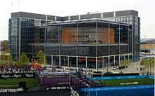
- Brent Civic Centre
- Shree Swaminarayan Temple, Kingsbury
Parks and open spaces[]
Sport and leisure[]
The Borough has three Non-League football clubs:
- Tokyngton Manor F.C., which plays at Spratleys Meadow.
- Wembley F.C., which plays at Vale Farm stadium
- South Kilburn F.C. which plays at Vale Farm stadium.
Town twinning[]
Brent is twinned with:
 South Dublin, Leinster, Ireland
Freedom of the Borough[]
The following people and military units have received the Freedom of the Borough of Brent.
This list is incomplete; you can help by . (July 2020) |
Individuals[]
Military Units[]
References[]
- ^ "Brent welcomes in a new Mayor". Brent Council. Retrieved 6 June 2019.
- ^ 2011 Census: Ethnic group, local authorities in England and Wales, Office for National Statistics (2012). See Classification of ethnicity in the United Kingdom for the full descriptions used in the 2011 Census.
- ^ King, Rosamund & Barres-Baker, Malcolm - Britain in Old Photographs: The London Borough of Brent (Stroud, The History Press, 2011) p.4 ISBN 0-75245-827-2
- ^ Borough of Brent official website, brent.gov.uk; accessed 7 December 2014.
- ^ "Local council election results 2018 - in full". The Guardian. Retrieved 30 June 2019.
- ^ Volpe, Sam (22 June 2018). "Labour sweeps the board in delayed Willesden Green election". Brent & Kilburn Times. Retrieved 30 June 2019.
- ^ "Councillor details - Councillor Muhammed Butt". democracy.brent.gov.uk. 6 January 2021.
- ^ Boundary Commission Report of 1994 http://s3-eu-west-2.amazonaws.com/lgbce/__data/assets/pdf_file/0008/11897/651.-london-borough-of-brent-and-its-boundaries-with-barnet,-camden,-ealing,-hammersmith-and-fulham,-harrow,-knc-and-westminster.pdf
- ^ Local Area Migration Indicators, UK: Office for National Statistics. Published on 27 August 2020.
- ^ Nicholas Timmins (13 December 1995). "London: Europe's new ethnic melting pot". The Independent. Retrieved 8 December 2019.
- ^ John Windsor (1 January 1994). "Digging for treasure in a dustbin: It may be the most boring museum in the world, full of the ephemeral bric-a-brac of recent history, but to his surprise, John Windsor has become a fan of The Grange in Neasden". The Independent. Retrieved 8 December 2019.
- ^ https://discovery.ucl.ac.uk/id/eprint/10103917/1/Racial_segregation_in_London.pdf[bare URL]
- ^ Key Figures for 2001 Census: Census Area Statistics: Brent, neighbourhood.statistics.gov.uk; accessed 25 February 2009.
- ^ 2011 Census data, accessed 4 November 2013.
- ^ "Ward Profiles and Atlas – London Datastore".
- ^ "2011 Census data".
- ^ "Layout 1" (PDF). Retrieved 8 December 2019.
- ^ "The London Borough of Brent". Onedome.com. Retrieved 8 December 2019.
- ^ "Brent".
- ^ https://www.whatdotheyknow.com/request/492406/response/1187217/attach/html/5/Brent Council Controlling Migration Fund application.pdf.html
- ^ Brent profile by religious adherence, http://neighbourhood.statistics.gov.uk; accessed 7 December 2014.
- ^ https://www.thejc.com/news/uk-news/schools-to-expand-1.434349[bare URL]
- ^ "House of Commons - Female genital mutilation: abuse unchecked - Home Affairs Committee". publications.parliament.uk. Retrieved 9 November 2018.
- ^ "London areas have higher TB than Iraq". 27 October 2015. Retrieved 15 January 2019.
- ^ "KS006 - Ethnic group". NOMIS. Retrieved 30 January 2016.
- ^ "Ethnic Group by measures". NOMIS. Retrieved 8 January 2016.
- ^ "Travel Weather Averages (Weatherbase)". Weatherbase.
- ^ "Brent, England: Monthly - Weather Averages Summary". Weatherbase. CantyMedia. 2016. Retrieved 7 December 2014.
- ^ "Diageo Contacts." Diageo. Retrieved on 1 September 2011. "Diageo plc Lakeside Drive Park Royal London NW107HQ"
- ^ "Brent Boundary (approximate) Archived 1 February 2012 at the Wayback Machine." London Borough of Brent. Retrieved on 1 September 2011.
- ^ Jump up to: a b Dunkley, Jamie. "Drinks maker Diageo to close London office", The Daily Telegraph, 20 March 2009; retrieved 1 September 2011.
- ^ Innes, John. "Guinness closes UK brewery", The Scotsman. 16 April 2004; retrieved 1 September 2011.
- ^ Thousands of Brent children in severe poverty, harrowobserver.co.uk; accessed 7 December 2014.
- ^ Jump up to: a b "Mass sign-up to London recycling scheme". BBC News (UK, England). 2 August 2008. Retrieved 29 March 2015.
- ^ Jump up to: a b c London Fire Brigade - Brent Profile, london-fire.gov.uk; accessed 7 December 2014.
- ^ "2011 Census: QS701EW Method of travel to work, local authorities in England and Wales". Office for National Statistics. Retrieved 23 November 2013. Percentages are of all residents aged 16-74 including those not in employment. Respondents could only select one mode.
- ^ "Nelson Mandela given freedom of borough of Brent". 24 June 2013 – via www.bbc.com.
External links[]
| Wikimedia Commons has media related to London Borough of Brent. |

Coordinates: 51°33′58″N 0°16′26″W / 51.56611°N 0.27389°W

| Authority control |
|
|---|
- London Borough of Brent
- London boroughs
- 1965 establishments in the United Kingdom