South Dublin
South Dublin
Átha Cliath Theas | |
|---|---|
County | |
 Coat of arms | |
Motto(s):
| |
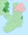
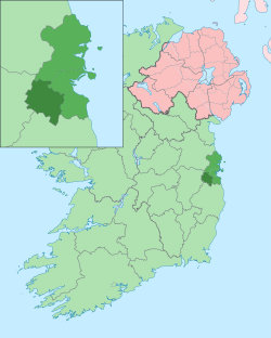 Inset showing South Dublin (darkest green in inset) within Dublin Region (lighter green) | |
| Country | Ireland |
| Province | Leinster |
| Dáil Éireann | Dublin Mid-West Dublin South-Central Dublin South-West |
| EU Parliament | Dublin |
| Established | 1994 |
| County town | Tallaght |
| Government | |
| • Type | County Council |
| Area | |
| • Total | 222.74 km2 (86.00 sq mi) |
| Highest elevation (Kippure) | 757 m (2,484 ft) |
| Population (2016) | |
| • Total | 278,749 |
| • Density | 1,300/km2 (3,200/sq mi) |
| Time zone | UTC±0 (WET) |
| • Summer (DST) | UTC+1 (IST) |
| Vehicle index mark code | D |
| Website | www |
South Dublin (Irish: Átha Cliath Theas) is a county in Ireland, within the province of Leinster, and the Dublin Region, the successor to County Dublin, from which its name derives. South Dublin County Council is the local authority for the county. The county contains both dense suburbs of Dublin and stretches of unpopulated mountain. In 2011 it had a population of 278,749, making it the third most populous county in the state.[1]
Geography and population[]
South Dublin has an area of 222.74 square kilometres (86 sq mi), making it the second largest administrative county in Dublin. It is bounded by Dublin City (15 km, 9.3 mi to the north east), the River Liffey (separating it from Fingal to the north), Dún Laoghaire–Rathdown (to the east), County Kildare (to the west) and its hills adjoin the mountains of County Wicklow to the south.
The county town is Tallaght. Other important centres of population are Lucan and Clondalkin. Much of the county is heavily urbanised but small rural settlements exist in the southern and western parts. South Dublin had a population of 278,749 according to the 2016 census.[1]
Towns and villages[]
Several urban areas in South Dublin County are also traditionally suburbs of Dublin city. For the purposes of planning and management, the County Council designates the status of towns, villages and suburbs in three tiers - town, district centre and local centre. In the current development plan,[2] the towns and district centres are listed as:
- Tallaght, the county seat and the location of The Square Shopping Centre which was opened in October 1990
- Clondalkin ("to be facilitated and developed as a Town Centre... including northward development")
- Lucan (with notes on the Liffey Valley Centre, and the developing Adamstown area - a future "district centre" - and a stated aim to avoid Lucan merging with Leixlip)
- and with a proposal to develop a Town Centre around the Liffey Valley Centre at Quarryvale
while the more local centres are noted in three groups:
- city suburbs including at least Rathfarnham, Ballyroan, Palmerstown, Terenure, Templeogue, Knocklyon, Firhouse, Ballycullen and Greenhills
- villages such as Rathcoole, Newcastle(-Lyons), and Saggart
- new neighbourhoods, some within bigger, older areas - including such as Kilnamanagh, Ballyowen, Finnstown, and, in development, Adamstown (mentioned in the county plan as an extension of Lucan).[3]
Residential areas[]
Legal status and terminology[]
In Ireland, the usage of the word county nearly always comes before rather than after the county name; thus "County Clare" in Ireland as opposed to "Clare County" in Michigan, USA. In the case of those counties created after 1994, they often drop the word county entirely, or use it after the name; thus for example internet search engines show many more uses (on Irish sites) of "South Dublin" than of either "County South Dublin" or "South Dublin County". There appears to be no official guidance in the matter, as even the local authority uses all three forms.[4]
In 2015, South Dublin became part of the Eastern and Midland Region.[5]
Local government in the region is further regulated by the Local Government Act 1994. This provided for the legal establishment of the following local government administrative areas:
- Dún Laoghaire–Rathdown
- Fingal
- South Dublin
and also recognised the extant Dublin Corporation area, vesting its powers in a renamed entity - Dublin City Council. The statutory instrument giving effect to the Act came into force on 1 January 1994.[6] The instrument also provided for the abolition of Dublin County Council - the entity that had previously had responsibility for Dún Laoghaire–Rathdown, Fingal and South Dublin. The four entities collectively comprise the former entity known as County Dublin. This entity, which had been created during the Norman invasion of Ireland, was abolished under the Acts.
South Dublin was based on an existing electoral division, Belgard Irish: An Bealach Ard, whose boundaries were only finalised in 1993, to accommodate the M50 motorway, and then used when it was made an Administrative County in 1994 (Fingal and Dún Laoghaire–Rathdown's boundaries and names were both set in 1985). The name of Belgard did have a historical association with the area, being the designation of one of the border fortresses of the Pale that existed in that area. It was altered, however, due to a view that the name Belgard might create associations with areas of modern development in Tallaght that now also use that name.[citation needed] Various organs of state use alternative subdivisions of the Dublin region for administrative reasons, for example the Dublin postal codes.
Local government and politics[]
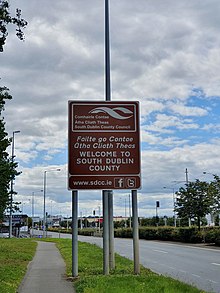
South Dublin County Council is the local authority for the county. It was established at County Hall at the same time that Dublin County Council and the Corporation of Dún Laoghaire were abolished[7] in 1994, by an Act of the Oireachtas, the Local Government (Dublin) Act 1993. It is one of four councils in the Dublin Region. The county is divided into five local electoral areas for the purpose of elections:[8] Clondalkin (6 councillors), Lucan (5 councillors), Rathfarnham (4 councillors), Tallaght Central (6 councillors), and Tallaght South (5 councillors).
Parts of four constituencies for elections to Dáil Éireann are contained within the county's borders. They are: Dublin Mid-West, Dublin South-West, Dublin South and Dublin South-Central. From 1885 to 1922, much of the area of the present county was encompassed by the historic Westminster constituency of South County Dublin.
Demographics[]
| Main immigrant groups, 2016[9] | |
| Nationality | Population |
|---|---|
| 9,159 | |
| 7,988 | |
| 3,235 | |
| 2,726 | |
| 2,644 | |
| 2,620 | |
| 1,499 | |
| 1,434 | |
| 999 | |
| 971 | |
Symbols[]
The heraldic crest for South Dublin has the inscription "This We Hold In Trust" in both English and Irish, while incorporating elements relating to the history, geography and present day infrastructure of the area.[citation needed]
Sport[]
The League of Ireland club Shamrock Rovers plays at Tallaght Stadium. The stadium hosted the 2009 FAI Cup Final and the Setanta Sports Cup final in 2010 & 2011.
The National Basketball Arena in Tallaght is the home venue for both the Ireland national basketball team and Ireland women's national basketball team. The arena also hosts various National Cup & League matches.
Town twinning[]
South Dublin is twinned with the London Borough of Brent, United Kingdom.[citation needed]
References[]
- ^ Jump up to: a b Census 2016 - Population of each province, county and city Archived 17 April 2011 at the Wayback Machine
- ^ County Development Plan 2004-2010 Archived 23 January 2010 at the Wayback Machine, South Dublin County Council. Retrieved 12 August 2010.
- ^ Tallaght, Dublin, Ireland[permanent dead link], South Dublin County Development Plan 2004-2010, Chapter 5 [PDF]
- ^ Fingal County Council website, where (apart from references to the Council itself) both "Fingal County" and "County Fingal" appear, but much less frequently than "Fingal" alone.
- ^ "Eastern and Midland Regional Assembly". Eastern & Midland Regional Assembly. Retrieved 30 September 2016.
- ^ Local Government (Dublin) Act, 1993:
Section 2: "the county", in relation to any time before the establishment day, means the administrative county of Dublin
Section 9(1) On the establishment day— ... (a) the county shall cease to exist. - ^ "Local Government (Dublin) Act, 1993, Section 9.—(1)"
- "On the establishment day—
- (a) the county shall cease to exist,
- (b) the borough shall cease to exist,
- (c) the electoral counties shall cease to exist, and
- (d) the united district of the burial board shall cease to exist."
- "On the establishment day—
- ^ "Local Elections – Electoral Area Details". ElectionsIreland.org. 2009. Retrieved 15 February 2010.
- ^ "Central Statistics Office". Retrieved 12 May 2019.
External links[]
| show Places in South Dublin |
|---|
| show Regions of County Dublin |
|---|


- South Dublin (county)
- Counties of the Republic of Ireland
- County Dublin
- Local administrative units of the Republic of Ireland