Dún Laoghaire
This article needs additional citations for verification. (November 2019) |
Dún Laoghaire | |
|---|---|
Town | |
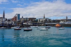 Dún Laoghaire Harbour | |
 Dún Laoghaire Location in Ireland | |
| Coordinates: 53°18′N 6°08′W / 53.30°N 6.14°WCoordinates: 53°18′N 6°08′W / 53.30°N 6.14°W | |
| Country | Ireland |
| Province | Leinster |
| County | Dún Laoghaire–Rathdown |
| Elevation | 24 m (79 ft) |
| Population (2016)[1] | |
| • Total | 26,525 |
| incl. near districts (Glenageary, Sallynoggin, Salthill, etc.) | |
| Eircode (Routing Key) | A96 |
| Area code(s) | 01 (+3531) |
| Website | www |


Dún Laoghaire[15] (/dʌn ˈlɪəri/ dun LEER-ee, Irish: [ˌd̪ˠuːn̪ˠ ˈl̪ˠeːɾʲə, - ˈl̪ˠiːɾʲə]) is a suburban coastal town in the traditional county of Dublin in Ireland. It is the county town of Dún Laoghaire–Rathdown, one of the three authorities that replaced the old Dublin County Council.
The town was built following the 1816 legislation that allowed the building of a major port to serve Dublin. It was known as Dunleary until it was renamed Kingstown in honour of King George IV's 1821 visit, and in 1920 was given its present name, the original Irish form of Dunleary. Over time, the town became a residential location, a seaside resort and the terminus of Ireland's first railway.
Toponymy[]

The town's name means "fort of Laoghaire".[16] This refers to Lóegaire mac Néill (modern spelling: Laoghaire Mac Néill), a 5th century High King of Ireland, who chose the site as a sea base from which to carry out raids on Britain and Gaul. Traces of fortifications from that time have been found on the coast, and some of the stone is kept in the Maritime Museum.
The name is officially spelt Dún Laoghaire in modern Irish orthography; sometimes unofficially Dún Laoire.[17][18] The old anglicised spelling Dunleary is also seen.[17][19] This last is how the town's name is commonly pronounced.[20]
History[]
This section needs additional citations for verification. (July 2019) |
Origins[]
Dún Laoghaire's origins are generally assumed to trace back to a fort that is believed to have stood there and mostly likely to have belonged to Lóegaire mac Néill.[16] A 1686 map of Dublin Bay by Greenvile Collins gives the name as Dun Lerroy. A later map from 1728 shows a small fishing village at the old harbour, marked as Dunlary or in other later maps as Dunleary.[21] The earlier village was around the area where the Purty Kitchen pub is now (sometimes mapped as "Old Dunleary"). It had a coffee house and a small cove, both of which are shown on a number of old maps, and it may have had a salt mine (Salthill is close by). At that time, the area was a craggy, rocky pastureland spotted with some granite quarries.[22]

By around 1800, some maps show a small centre of habitation along what is now Cumberland Street, close to the junction with York Road.
The harbour project[]
On the night of 18–19 November 1807, two troopships, the Prince of Wales, and the Rochdale, which had departed from Dublin, were driven on the rocks between Blackrock and Dún Laoghaire with the loss of over 400 lives. This disaster gave new impetus to an existing campaign for a harbour to be constructed near Dublin. By 1816, the legislation was passed authorising the construction of what is now called the "West Pier". The lines of the current town centre including George's Street and most adjoining streets are clearly shown on maps prepared for the development of the harbour, and in particular on a John Rennie plan of 1817, when construction of that town centre had barely commenced at the western end of George's Street. That street may originally have been laid out as a military road connecting the Dún Laoghaire Martello Towers—one at the Peoples Park, the other near the end of the West Pier—both of which have long disappeared. Whatever its origins, the street was clearly an engineer's design, being ruler-straight for all of its length (except the small western part which clearly pre-dates 1816).
When King George IV came to visit the new port under construction in 1821, the name Dunleary was dropped in favour of "Kingstown"; the town returned to its former name in August 1920, in the lead-up to the creation of the Irish Free State.[23] By the time the Ordnance Survey was completed around 1845, the maps show buildings on much of the street and adjacent streets.
Railways[]
Ireland's first railway (costing £200,000) and covering the five and a half miles from Dublin (Westland Row) to Kingstown was opened on 17 December 1834, terminating at the old harbour of Dunleary which adjoins today's the West Pier.[24] Soon afterwards the railway was extended to Victoria wharf (later St. Michael's Wharf of Dun Laoghaire harbour. Originally fares were sixpence (third class), eight pence (second class) and a shilling (first class). The journey took 15 minutes in 1837.[25] The railway established Kingstown as a preferred suburb of Dublin and led to the construction of residential terraces. Gresham Terrace (now demolished) consisted of eight houses which formed one side of Victoria Square, so named at the request of Princess Victoria. [26] Much of Victoria Square has been built over by the Pavilion Theatre and apartments.
By 1844 the Atmospheric Train (designed by Robert Mallet)[citation needed] connected Kingstown to Dalkey, leading to further development. The Atmospheric Train ceased in 1854[27] but was replaced by the extension of the railway, which was subsequently extended to the ferry port of Rosslare. The opening of the railway from Dublin saw Kingstown become a Victorian era seaside resort.
1890 to 1916[]
In 1890, the Kingstown Town Commissioners established the People's Park on the site of a depleted quarry. By 1900, the centre of the town was congested and steps were taken to widen the street. These steps included the demolition of shop frontages on George's Street from Patrick Street to Mulgrave Street, and their replacement by new frontages stepped back about 5 yards (4.5m). Shops on the corner of Marine Road and George's Street were also demolished.
The British 59th (2nd North Midland) Division disembarked at Kingstown in April 1916 and marched up the road to Dublin, to participate in the response to the Easter Rising. Adjacent to the Carlisle Pier and overlooked by the National Maritime Museum of Ireland, there is an anchor, recovered from the wreck of the mailboat RMS Leinster which was torpedoed over the Kish Bank in 1918, with the loss of over 500 lives.
Since 1921[]
The main road to Dublin, through Monkstown village and Blackrock, was the sole road connection to the city of Dublin until 1932. In that year, the Eucharistic Congress brought thousands of visitors to Dublin, and plans indicated that most of them would come through Dún Laoghaire. The road was considered inadequate, and a new coast road was created by connecting some short segments of road and closing some gardens. This road is now Seapoint Avenue. An agreement with the local residents to restore the area to the pre-Congress condition was never fulfilled.
Dún Laoghaire was hit by stray German bombs during the Second World War, with a couple of them landing near the People's Park at Rosmeen Gardens. Damage from the bombs was limited to buildings.[28]
Features[]
The harbour[]
The harbour, one of the largest in the country, is notable for its two granite piers. The East Pier is particularly popular with walkers, and was featured in the 1996 film Michael Collins, where Liam Neeson (as Collins) and two of his co-stars are seen walking along a seaside promenade, which is actually the Dún Laoghaire East Pier. A band is seen playing on a bandstand in this film scene, and this is the actual bandstand on the East Pier. The bandstand was restored to its original condition in 2010 by the Dún Laoghaire Harbour Company.[29]
It took 42 years to construct the harbour, from 1817 to 1859. Initially it was thought that one pier (east pier) of 3,500 feet would be sufficient to provide shelter to shipping. It wasn't until the first pier was in use that the authorities realised the need for protection from winds from the west and north west.[30] The West Pier was commenced in 1820 and was constructed with a length of 4,950 feet. The mouth of the harbour is 850 feet wide. The piers were built of perfectly square blocks (50 cubic feet) of Runcorn sandstone from foundation level up to 14 feet high. From six feet below low water level to coping level, the piers are built of Dalkey granite. The piers are 310 feet wide at foundation level, and 53 feet wide at the summit.[31]
An obelisk standing on four granite balls located near the old ferry port terminal at the harbour commemorates the departure of King George IV and the renaming of the place as Kingstown.

A lighthouse was at the end of the East Pier, while the new headquarters of the Commissioners of Irish Lights (the General Lighthouse Authority for Ireland) is on Harbour Road.
Other coastal features[]
South of the harbour is Scotsman's Bay, where there was a Victorian seaside amusement area, with walks, shelters and baths. The walks and shelters are largely intact. Dún Laoghaire Baths have been derelict for many years, but were repainted in bright colours in 2012.[32] Plans for restoration of this area are much debated, and some of the more ambitious ideas have been highly controversial.
Parks and community facilities[]
A traditional Victorian-style park, the People's Park, is at the eastern end of George's Street, and including still-functioning tea rooms.
Community facilities include the Boylan Community Centre, the Dún Laoghaire Scout Den, and a community information service in the tower building of St Michael's Church.
A large modern library, the Lexicon, which contains the county library headquarters too, was built by the harbour in recent years.[33]

Rescue services[]
An inshore and offshore lifeboat operated by the RNLI are based in Dún Laoghaire Harbour. The offshore boat is normally moored adjoining the Carlisle Pier. The inshore boat is stored in a stone shed at the base of the East Pier. Until recently lifeboat crews were called to duty using a maroon launched from the shore base.
Historical features[]
At least one traditional "cabman's shelter" survives – these were small buildings built for the drivers of horse-drawn taxis.[citation needed]
Transport[]

Public transport[]
Dún Laoghaire is connected to central Dublin by the DART services, the South Eastern Commuter line and the mainline rail service that runs from Dublin to Rosslare. The town is also served by several bus routes which are the 7, 7a, 45a, 46a, 59, 63, 75 and 111 operated by Dublin Bus and Go-Ahead Ireland. The railway station is beside the terminus of the 63, 75 and the 46a, the most frequent and heavily used bus route in Dublin. The 746 bus route from the station terminus to Dublin Airport was discontinued in October 2010. Sandycove and Glasthule and Salthill and Monkstown also serve the area.
An Aircoach service links the area with Dublin Airport 24 hours a day with stops at County Hall and the Royal Marine Hotel. Route 703 travels from Killiney to Dublin Airport via Dalkey, Glasthule, Dún Laoghaire, Monkstown, Blackrock, Booterstown, Tara Towers hotel, Strand Road and The Point (3Arena).[34]
Rail history[]
The Dublin and Kingstown Railway, constructed and opened in 1834, was the first-ever railway in Ireland and was built to standard gauge. Extension southward was by the standard gauge Dalkey Atmospheric Railway publicly opened in 1844 which was the first railway to have practical and commercial application of pneumatic power. In the 1850s, the Dublin and Wicklow Railway took over both lines, converting both to Irish gauge and the latter to steam locomotive haulage whilst extending further south to Bray, Wicklow. Successor companies operating the railway were: Dublin, Wicklow and Wexford Railway; Dublin and South Eastern Railway; Great Southern Railways; CIÉ; and Iarnród Éireann. An extension to Carlisle Pier for the boats operated from 1859 until 1980. The railway was subsequently extended to the south to Wexford, Rosslare Harbour and Waterford. Northwards in 1890 the line was extended to Connolly station connecting to other railways.[35] Electrification arrived in 1984, and the electrified suburban service was branded as DART. There are also Dublin Bus and Go-Ahead Ireland (since September 2018) services that operate near the station as well as around Dún Laoghaire.
Ferry[]
From the 19th century, the town was the principal passenger port for ferries between Ireland and Britain, with a frequent service to Holyhead in Anglesey, Wales. Among the ships which operated this route were "Banshee", "Llewellyn", "Ulster", "Munster", "Leinster", "Connaught", "MV Cambria", "MV Hibernia", "Princess Maud",[36] "Holyhead Ferry 1", "St. Columba" and "Stena Cambria".[37] At the beginning of the 21st century the route, operated by Stena Line's Stena Explorer ran three times daily in each direction, but competition from low-cost airlines and increasing fuel costs resulted in the service being reduced to once-daily in 2008, and becoming a seasonal (summer-only plus Christmas/New Year) from 2010. From early 2015 Stena Line concentrated their Holyhead routes on Dublin Port, and withdrew the service to Dún Laoghaire.[38]
Pedestrianisation[]
In the early 2000s, Lower George's Street underwent pedestrianisation, placing a ban on all general traffic with the exception of bus routes toward central Dublin. Bus routes coming along this road into Dún Laoghaire were re-routed along the seafront.[clarification needed] This restriction was reversed in late 2008. Dún Laoghaire Business Association later (unsuccessfully) called for local parking charges to be reduced to one euro per hour (to compete with Dundrum Shopping Centre which then charged two euro for three hours).[39][not specific enough to verify]
Sports[]
Boating[]

Regattas have taken place in Kingstown since at lest 1837.[40] Dún Laoghaire harbour is home to a number of yacht clubs of which Dublin Bay Sailing Club incorporating the Royal Alfred yacht Club is the largest. it organises racing for dinghies and keelboats on Tuesdays, Wednesdays, Thursdays and Saturdays from April to September.
Other clubs include the Dún Laoghaire Motor Yacht Club with premises on the West Pier, the Irish National Sailing School & Irish National Sailing Club based at the foot of the West Pier, the Sailing in Dublin Club with premises in the Coal Harbour, the Royal Irish Yacht Club between the Commissioners for Irish Lights and the marina entrance, the Royal St George Yacht Club ( built 1842)[41] opposite the Pavilion Centre, National Yacht Club (built 1870)[42] closest to the East Pier and the Irish Youth Sailing Club which is run by the Dún Laoghaire Coast Guard Kyron O'Gorman and located on the East Pier.
The area to the north of the West Pier at Salthill Beach once saw windsurfing activity over the twelve months of the year.
St Michael's Rowing Club,[43] one of the longest-established members of the East Coast Rowing Council, has its roots in Dún Laoghaire harbour since the hobblers of the 18th and 19th centuries. The club itself has existed since the early 1920s and still resides in the Coal Harbour boatyard today. Members can regularly be seen rowing their traditional, clinker-built skiffs around the harbour and Scotsman's Bay throughout the year.
The Water Wag Club[44] was founded in Kingstown in 1887 to "Establish a class of sailing punt with centreboard all rigged and built the same so that an even harbour race can be had with a light rowing and generally useful boat". This was the first time in yachting history that all the boats in a race should be identical, and that the winner would be the man with the greatest skill. This concept of 'One-design' has become the norm worldwide and has been adopted for all Olympic sailing events and for most World Championships in sailing. The Water Wag club prospers some 134 years later, and 'Wags' can be seen sailing in Dún Laoghaire harbour on Wednesday evenings from late April to mid-September every year.
Marina[]
The 820-berth marina is the largest in the country, and opened in 2001 following resistance for over 15 years by a group led by the late John de Courcy Ireland, the maritime historian. A 240-berth extension, involving an investment of €3 million, was approved in June 2006 by An Bord Pleanála; the project was completed in April 2007. The marina was the first in Ireland to be awarded a 5 Gold Anchor rating.
Horse racing[]
Horse racing was undertaken annually in the 1830s for the entertainment of the residents. The location for these events was at the top of York Road where several houses have names such as 'Racefield'.[citation needed] These events no longer take place.[citation needed]
Golf[]
The town had a golf club from 1909 to 2007, but its members agreed to sell the course to housing developers and move to Ballyman Road, near Enniskerry in County Wicklow. The golf club was on a site now occupied by Honeypark and Cualanor.
Education[]

The Dún Laoghaire area is home to three third-level education establishments; Dún Laoghaire Institute of Art, Design and Technology (IADT), Dun Laoghaire Further Education Institute[45] (DFEi) formerly called Dún Laoghaire College of Further Education (DCFE)[46] on Cumberland Street in Dun Laoghaire town, and Sallynoggin College of Further Education (SCFE).[47]
Primary schools in the Dún Laoghaire area include Dominican Primary School Dún Laoghaire,[48] Holy Family National School in Monkstown Farm;[49] and Monkstown Educate Together National School (METNS) on Kill Avenue, Dún Laoghaire. Another nearby primary school is Harold National School, Glasthule founded in 1872.[citation needed]
A number of secondary schools around Dún Laoghaire closed in the 1990s. These school closures included CBS Eblana Avenue, founded in 1856 and closed in 1992 (although the fee-paying school C.B.C. Monkstown which relocated from Eblana continues to this day); the Dominican Convent girls' school, which closed a year earlier in 1991; Dun Laoghaire Community College (previously Dun Laoghaire Tech) which changed to a Further Education Institute in 1996 and to Dun Laoghaire Further Education Institute (DFEi) since then. Presentation Brothers in Glasthule, founded in 1902, was closed in 2007.[citation needed]
Shopping and business[]

Dún Laoghaire has one main shopping street, George's Street, as well as two shopping centres: the Dún Laoghaire Shopping Centre and Bloomfields, the former dating from 1977. Recent years have seen some commercial development of the land around the George's Street area, including, notably, the old Pavilion Cinema and Theatre site opposite the County Hall. There is a regular antique fair held bi-monthly, on Sundays in the Royal Marine Hotel, near the harbour, and a weekly farmers market held in the People's Park on Sundays.
There has been plenty of new investment in the area recently, and the Dún Laoghaire Shopping Centre will be subject to renovation by its owners Coltard, starting from 2016.[50]
The town has a wide range of eating places and public houses, as well as more than one hundred other retail businesses. The town is home to the head office of Ireland's largest supermarket operator, Tesco Ireland, whose stores previously anchored both major shopping centres in the town. But the one in Dún Laoghaire Shopping Centre which had been in operation since 1977, closed in May 2011 leaving only the one in Bloomfields.[51] The Tesco store in Dún Laoghaire Shopping Centre has subsequently been replaced by SuperValu.
Dún Laoghaire also holds other company headquarters, such as those of Bord Iascaigh Mhara and Lionbridge Ireland.
There is an active Business Association and Chamber of Commerce.
In 2018, developer Philip Gannon axed a project to convert the former ferry terminal at Dún Laoghaire into a €20 million digital hub that had been projected to bring in 1,000 jobs and 50 companies. Gannon accused Dún Laoghaire Harbour Company of failing to secure the rights to lease the ferry terminal, despite advertising it for lease.[52]
Health[]
Early residents moved to Dun Laoghaire for the purity of its air compared with Dublin city.[citation needed]
Dún Laoghaire is home to St Michael's Hospital as well as a number of private clinics, therapists and general practitioners.
Culture[]

Dún Laoghaire has associations with many leading cultural figures, most notably James Joyce and Samuel Beckett. In the second chapter of Ulysses, Joyce refers to Kingstown Pier as a "disappointed bridge," and in the opening chapter is based on his stay with Oliver St John Gogarty at a Martello tower located in nearby Sandycove. This tower, known as the James Joyce Tower, now contains a small museum. Samuel Beckett came from nearby Foxrock and is said to have experienced an artistic epiphany, alluded to in his play Krapp's Last Tape, while sitting on the end of one of Dún Laoghaire's piers. A bronze plaque marks the spot.
The baritone Frederick Ranalow, who performed close to 1,500 performances in The Beggar's Opera, was born in Kingstown, although he moved to England at an early age.[citation needed]
The black equestrian and circus owner Pablo Fanque, immortalised in the Beatles' song Being for the Benefit of Mr. Kite!, performed here for one week during a long engagement in Dublin, in 1850.[53]
In August 1991, Seattle grunge band Nirvana played at the Top Hat.[54]
Dún Laoghaire was previously home to the Festival of World Cultures, a three-day festival dedicated to music from all corners of the globe. It was one of the largest music festivals in Ireland attracting over a quarter of a million visitors to the town over a weekend in August. For nine years (2001–2010), the festival was a huge success, but Dún Laoghaire Rathdown County Council decided to stop hosting the festival after its large losses in 2010.[55]
A new purpose-built theatre, the Pavilion Theatre, opened its doors in 2000. Built on the site of the 1903 Kingstown Pavilion, it serves as the municipal theatre for Dún Laoghaire-Rathdown, and is a host venue for a number of important festivals, including the International Puppet Festival, and, recently, the Dublin Theatre Festival.
St Michael's Church is home to the longest-running series of organ concerts in Ireland, featuring the 1974 organ by Rieger Orgelbau which is the only organ of its type in Ireland.[citation needed]
The National Maritime Museum of Ireland is housed in Mariners' Church, which formerly served the Royal Navy. It is directly inland from the East Pier. The building has been completely renovated and reopened.[56]
Beside the maritime museum is the DLR Lexicon, the central library and cultural centre of DLR County Council. It opened in 2014, replacing the Carnegie library opened in 1912 on Library Road.[57] Costing an estimated €36.6 million, the new building attracted much criticism prior to its opening on account of its size and design.[58]
Off Library Road is the Dominican Oratory of the Sacred Heart, a small oratory described as a "gem of Celtic Renaissance art".[59] It was designed by John J. Robinson, architect of Robinson and Keefe Architects and decorated by Sr. Lynch for members of the former Dominican Convent which existed on the site of the Tesco-anchored "Bloomfield" Shopping Centre.
Tourism[]
Much of the town's early growth came from visitors from Dublin, and today there is one large hotel, heavily refurbished in 2007, the Royal Marine, along with several small hotels, and a number of bed-and-breakfasts.
Outdoor activities[]
Walking the East Pier of Dún Laoghaire Harbour is the most popular tourism activity in Dún Laoghaire.[citation needed] The west pier is longer but the surface of the pier is less suitable for walking.
In July 2013, the first-ever tourism office opened in Dún Laoghaire. Kayaking, kite surfing, paddle boarding and sailing are available, along with facilities for biking and rock climbing.
Dublin Bay Cruises[]
Dublin Bay Cruises sail twice a day from Dún Laoghaire to Howth. The scenic trip takes about 75 minutes.[citation needed]
Cruise ship visits[]

In 2011, Dún Laoghaire Harbour published a master plan, which focused on developing Dún Laoghaire as a tourist destination. Specifically, the plan revolved around promoting Dún Laoghaire Harbour as a prime location for both ferries and cruise ships. Since then, many cruise ships have stopped in Dún Laoghaire, usually between the months of May and July. The first ship to arrive was the Cunard liner RMS Queen Mary 2 on 16 May, and P&O's MV Arcadia arrived on 9 July. The Queen Mary 2 was the 7th largest cruise ship in the world at the time, with a maximum passenger capacity of about 3,000.[60] Other large vessels to visit Dun Laoghaire include the QE2 and the aircraft carrier USS John F. Kennedy.
People[]
- See Category:People from Dún Laoghaire
Governance and representation[]

Dún Laoghaire was once the core element of the borough of Dún Laoghaire, and until 2013 remained the only town in Ireland to have its own Vocational Education Committee. It is considered part of the Greater Dublin Area.
The area is governed locally by Dún Laoghaire–Rathdown County Council which is based at County Hall and is responsible for the provision of local services and amenities. For elections, the town is part of the Dún Laoghaire local electoral area which elects six councillors.
For elections to Dáil Éireann the town is part of the Dún Laoghaire constituency which is currently represented by four TDs; one from Fianna Fáil, one from Fine Gael, one from the Green Party and one from People Before Profit. The former Tánaiste, Eamon Gilmore, who resides in Shankill to the south, was one of the TDs from the constituency between 1989 and 2016.
International relations[]
Dún Laoghaire has a town twinning relationship with the following cities.
![]() France: Brest[61]
France: Brest[61]
![]() Japan: Izumo[61]
Japan: Izumo[61]
![]() Wales: Holyhead[61]
Wales: Holyhead[61]
See also[]
- Kingstown Lifeboat Disaster
- List of towns and villages in Ireland
- List of RNLI stations
References[]
Notes[]
- ^ Population, not of the town of Dún Laoghaire, but all Dún Laoghaire Electoral Districts. Including: 042 East Central Archived 21 January 2018 at the Wayback Machine 043 Glasthule Archived 21 January 2018 at the Wayback Machine 044 Glenageary Archived 21 January 2018 at the Wayback Machine 045 Monkstown Farm Archived 21 January 2018 at the Wayback Machine 046 Mount Town Archived 21 January 2018 at the Wayback Machine 047 Sallynoggin East Archived 21 January 2018 at the Wayback Machine 048 Sallynoggin South Archived 21 January 2018 at the Wayback Machine 049 Sallynoggin West Archived 22 January 2018 at the Wayback Machine 050 Sandycove Archived 21 January 2018 at the Wayback Machine 051 Salthill Archived 21 January 2018 at the Wayback Machine 052 West Central Archived 21 January 2018 at the Wayback Machine
- ^ http://www.histpop.org Archived 7 May 2016 at the Wayback Machine
- ^ Lee, JJ (1981). "On the accuracy of the Pre-famine Irish censuses". In Goldstrom, J. M.; Clarkson, L. A. (eds.). Irish Population, Economy, and Society: Essays in Honour of the Late K. H. Connell. Oxford, England: Clarendon Press.
- ^ Mokyr, Joel; O Grada, Cormac (November 1984). "New Developments in Irish Population History, 1700–1850". The Economic History Review. 37 (4): 473–488. doi:10.1111/j.1468-0289.1984.tb00344.x. hdl:10197/1406. Archived from the original on 4 December 2012.
- ^ "CSO 1926" (PDF). cso.ie. Archived (PDF) from the original on 19 November 2017. Retrieved 1 May 2018.
- ^ "CSO 1936" (PDF). cso.ie. Archived (PDF) from the original on 19 November 2017. Retrieved 1 May 2018.
- ^ "CSO 1946" (PDF). cso.ie. Archived (PDF) from the original on 19 November 2017. Retrieved 1 May 2018.
- ^ "CSO 1951" (PDF). cso.ie. Archived (PDF) from the original on 19 November 2017. Retrieved 1 May 2018.
- ^ "CSO 1956" (PDF). cso.ie. Archived (PDF) from the original on 19 November 2017. Retrieved 1 May 2018.
- ^ "CSO 1961" (PDF). cso.ie. Archived (PDF) from the original on 19 November 2017. Retrieved 1 May 2018.
- ^ CSO 1966 Archived 25 January 2017 at the Wayback Machine
- ^ "CSO 1971" (PDF). cso.ie. Archived (PDF) from the original on 19 November 2017. Retrieved 1 May 2018.
- ^ Jump up to: a b CSO 1981 Archived 19 November 2017 at the Wayback Machine
- ^ Jump up to: a b "CSO 1991" (PDF). cso.ie. Archived (PDF) from the original on 19 November 2017. Retrieved 1 May 2018.
- ^ "Dún Laoghaire". Bunachar Logainmneacha na hÉireann. Archived from the original on 28 September 2013. Retrieved 10 February 2012.
- ^ Jump up to: a b Pearson (1981), p. 13.
- ^ Jump up to: a b "Dun Laoire? Dun Leary? Or Dun Laoghaire? How the harbour town got its name". Archived from the original on 17 October 2013.
- ^ Terry Janzen (26 October 2005). Topics in Signed Language Interpreting: Theory and practice. John Benjamins Publishing. pp. 64–. ISBN 978-90-272-9415-9. Retrieved 22 July 2013.
- ^ "Dunleary Road". Bunachar Logainmneacha na hÉireann. Archived from the original on 15 October 2013. Retrieved 10 February 2012.
- ^ "About Dun Laoghaire Town - Dun Laoghaire Tourism". dunlaoghaire.ie. Archived from the original on 1 February 2018. Retrieved 1 May 2018.
- ^ Pearson (1981), pp. 13–15.
- ^ Harbour Company (2003), pp. ii, 2–3.
- ^ "What's in a name? Dun Leary – Kingstown – Dún Laoghaire". Dún Laoghaire-Rathdown County Council. 7 July 2020. Archived from the original on 27 January 2021. Retrieved 29 May 2021.
- ^ Irish Family History Foundation (2020). "South Dublin Heritage & Genealogy Centre History". ROOTSIRELAND.
- ^ Lewis, Samuel (1837). A Topographical dictionary of the parishes, towns and villages of Dublin City and County.
- ^ Lewis, Samuel (1837). A Topographical Dictionary of the parishes, towns and villages of Dublin City and County.
- ^ Dun Laoghaire Harbour Company. "The Construction of Dun Laoghaire Harbour" (PDF). p. 7. Retrieved 16 December 2020.
- ^ Semple, Hilary (2019). "The night a bomb fell in our back garden in Sandycove, Co Dublin". The Irish Times. Retrieved 15 December 2020.
- ^ "Kingstown (Dun Laoghaire) Harbour". www.askaboutireland.ie. Archived from the original on 5 February 2018. Retrieved 1 May 2018.
- ^ Lewis, Samuel (1837). A topographical dictionary of the parishes, towns and villages of Dublin city and County.
- ^ Lewis, Samuel (1837). A Topographical dictionary of the parishes towns and Villages of Dublin City and County.
- ^ "Dún Laoghaire Baths get much needed lick of paint". RTÉ News. 3 April 2012. Archived from the original on 5 April 2012. Retrieved 3 April 2012.
- ^ "Dun Laoghaire's controversial library quietly opens its doors". The Irish Times. Archived from the original on 20 December 2016. Retrieved 2 December 2016.
- ^ "Archived copy". Archived from the original on 21 February 2014. Retrieved 22 February 2014.CS1 maint: archived copy as title (link)
- ^ Shepherd (1974), pp. 13–15, 24–30, 36, 38, 42, 47, 58–59, 93, 96.
- ^ "Princess Maud - Venus". Simplon Postcards. Archived from the original on 29 September 2017. Retrieved 4 February 2018.
- ^ History of Dun Laoghaire Harbour by John de Courcy Ireland
- ^ Hughes, Owen (4 February 2015). "Stena fast ferry from Holyhead to Ireland axed". Daily Post. Liverpool. Archived from the original on 25 April 2015. Retrieved 25 February 2015.
- ^ "December 2009". Dún Laoghaire Business. Dún Laoghaire: Dún Laoghaire Business Association. December 2009.
- ^ Lewis, Samuel (1837). A Topographical Dictionary of the parishes, towns and villages of Dublin City and County.
- ^ Peter Pearson, Stella Archer (1987). The Royal St George Yacht Club a history. Dun Laoghaire.
- ^ O'Sullivan, Donal (2020). The National. Clontarf: The Liffey Press. p. 22.
- ^ St Michael's Rowing Club Archived 2 February 2009 at the Wayback Machine
- ^ [The Waterwags 1887–2012 by Alfred and Vincent Delany.]
- ^ "Dun Laoghaire Further Education Institute". www.dfei.ie. Retrieved 30 January 2020.
- ^ "DFEi". www.dlcfe.ie. Archived from the original on 7 February 2009. Retrieved 1 May 2018.
- ^ "Sallynoggin College of Further Education". dife.ie. Archived from the original on 1 June 2016. Retrieved 1 May 2018.
- ^ "Primary School. Dominican Primary School Dun Laoghaire". Primary School. Dominican Primary School Dun Laoghaire. Archived from the original on 26 April 2018. Retrieved 1 May 2018.
- ^ "Scoilnet Web Hosting Holding Page for scoilnet.ie". www.holyfamilyns.scoilnet.ie. Archived from the original on 24 October 2009. Retrieved 1 May 2018.
- ^ "Coltard to revamp Dún Laoghaire shopping centre". The Irish Times. Archived from the original on 25 January 2016. Retrieved 25 January 2016.
- ^ "Tesco to close store in Dún Laoghaire centre, The Irish Times, 11 May 2011". irishtimes.com. Archived from the original on 24 October 2012. Retrieved 1 May 2018.
- ^ Taylor, Charlie (30 October 2018). "Developer scraps plans to turn Dún Laoghaire ferry terminal into digital hub". The Irish Times. Retrieved 30 October 2018.
- ^ The Freeman's Journal and Daily Commercial Appeal, 17 June 1850.
- ^ "25 years ago Nirvana came to Dún Laoghaire".
- ^ "No Festival of World Cultures in 2011? - On The Record". www.irishtimes.com. Archived from the original on 3 March 2016. Retrieved 1 May 2018.
- ^ "National Maritime Museum of Ireland". News. Maritime Institute of Ireland. Archived from the original on 5 September 2012. Retrieved 7 May 2012.
- ^ Dún Laoghaire-Rathdown County Council – press release Archived 25 November 2007 at the Wayback Machine
- ^ "New €36.6m Dún Laoghaire library criticised as 'monstrosity'". irishtimes.com. Archived from the original on 4 October 2017. Retrieved 1 May 2018.
- ^ "Heritage Week 2008 in Dún Laoghaire-Rathdown County". Dún Laoghaire-Rathdown County Council. Archived from the original on 18 May 2009. Retrieved 22 May 2009.
- ^ "Queen Mary 2 arrival to kick off Dun Laoghaire cruise ship season - Business - Business - Ireland's online business and management news service - Businessandleadership.com". businessandleadership.com. 14 May 2013. Archived from the original on 6 October 2014. Retrieved 1 May 2018.
- ^ Jump up to: a b c "International Relations And Twinnings - dlr Framework For Twinning". dlrcoco.ie. Dún Laoghaire-Rathdown County Council. Retrieved 5 November 2020.
Bibliography[]
- Cowsill, Miles; Hendy, John (1996). Holyhead-Dun Laoghaire: From Car Ferry to HSS 1965-1996. Narberth, Pembrokeshire: Ferry Publications. ISBN 1871947383.
- Harbour Company, Dun Laoghaire (2003). The Construction of Dun Laoghaire Harbour (PDF) (Report). Dun Laoghaire Harbour Company. Archived (PDF) from the original on 21 February 2019. Retrieved 27 July 2019.
- Merrigan, Justin (2016). Dun Laoghaire Holyhead 1826–2015: The rise and decline of Ireland's premier route. Ramsey, Isle of Man: Ferry Publications. ISBN 9781906608828.
- Pearson, Peter (1981). Dun Laoghaire Kingstown. Dublin: O'Brien Press. ISBN 0-905140-83-4. OL 22450451M.
- Shepherd, Ernie (1974). The Dublin & South Eastern Railway (1974 ed.). David and Charles. ISBN 0715363611.
External links[]
| Wikimedia Commons has media related to Dún Laoghaire. |
| Wikivoyage has a travel guide for Dún Laoghaire. |
- Dún Laoghaire-Rathdown County Council
- Dún Laoghaire Borough Historical Society
- Dún Laoghaire Harbour Company
| show Places in Dún Laoghaire–Rathdown |
|---|

| show Regions of County Dublin |
|---|

| show Authority control |
|---|
- Dún Laoghaire
- Towns and villages in Dún Laoghaire–Rathdown
- County towns in the Republic of Ireland
- Former boroughs in the Republic of Ireland
- Marinas in the Republic of Ireland
- Port cities and towns in the Republic of Ireland
- Port cities and towns of the Irish Sea
- Seaside resorts in the Republic of Ireland