Rialto, Dublin
This article needs additional citations for verification. (December 2021) |
Rialto
Rialto | |
|---|---|
Urban district | |
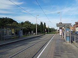 Rialto Luas stop looking east towards Fatima and Dublin city centre | |
 Rialto Location in Ireland | |
| Coordinates: 53°20′10″N 6°17′49″W / 53.336°N 6.297°WCoordinates: 53°20′10″N 6°17′49″W / 53.336°N 6.297°W | |
| Country | Ireland |
| Province | Leinster |
| County | Dublin City Council |
| Dáil Éireann | Dublin South-Central |
| European Parliament | Dublin |
| Elevation | 20 m (70 ft) |
| Eircode (Routing Key) | D08 |
| Area code(s) | 01 (+3531) |
Rialto (Irish: Rialto) is an inner suburb of Dublin, situated on the city's southside.
History and geography[]
Rialto is bounded to the east and north by The Liberties, St. James's Hospital and an original section of the Grand Canal stretching from Suir Bridge to James Street Basin, which was built for freight transport to and from the nearby Guinness brewery at St. James's Gate. This original section of the Grand Canal, disused since 1976, preceded an extension of the canal to Grand Canal Dock which today defines the district's southern and eastern edges.
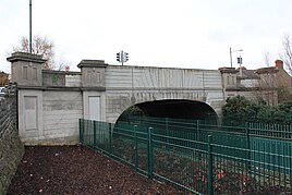
Rialto Bridge spans the original and disused portion of the Grand Canal which now forms part of the Luas Red Line.
St James's Walk overlooks this former spur of the canal, which led to the city basin.[1]
Transport[]
Rialto is located within Dublin's canal ring and at the western end of Dublin's South Circular Road, placing the area within walking distance of Dublin city centre and one of Ireland's main railway stations at Dublin Heuston.
The original portion of the Grand Canal running along the northern edge of Rialto and Fatima has in recent decades been repurposed as the Luas Red Line route connecting Dublin's Docklands at The Point and the city's southwestern suburbs at Tallaght. Rialto Luas stop is located a short distance from the Rialto Bridge and serves Rialto as well as the neighbouring district of Kilmainham and the site of the new National Children's Hospital.
The area is served by multiple Dublin Bus routes connecting with Dublin city centre and destinations such as University College Dublin and Blackrock in Dún Laoghaire–Rathdown and Greenogue in South Dublin.
St James's Walk/Colbert Fort housing scheme[]
St James Walk/Colbert Fort is a small triangular area in Rialto with surrounding areas including the Grand Canal and the Poodle river.
In the year 1915 there was two expressions of interest in this site. There wasn't any objections towards building on the site as the Corporation did already own the site, it was agreed that the housing would be extremely useful.[2]
After 1916, the site was auctioned off and the winning bid was from Mr Alexander Hull. Building was due to be complete in just nine months. Unfortunately due to many different problems such as the plan to widen the road, lack of men and materials and on top of that a strike ran by the craftsmen the project was not complete in the time frame given. After many setbacks the housing was handed over to the Corporation on the 21st March 1921. The naming of the streets was carried out with the intention of showing respect towards those who had fought during the 1916 rebellion. St James's Walk then became Colbert's Fort; the streets commemorated Malin, Clarke and MacCarthy. Many of the houses on Colbert's Fort are still standing today and add some intrigue onto the area.[2]
Famous residents[]
- Des Bishop, Irish-American comedian who lives in Rialto.
- Gay Byrne, (b.1934, d.2019) renowned Irish broadcaster and inaugural host of The Late Late Show who grew up in the area.
- Emma Dabiri, Irish-Nigerian author, broadcaster and social historian who grew up in Rialto.
- Louisa Flanagan, (b.1882, d.1959) daughter of Michael Flanagan and wife of the First President of the Executive Council W. T. Cosgrave.
- Michael "The Alderman" Flanagan, (b.1833, d.1931) a local councillor who was elected to Dublin Corporation.
- Willie "The Bird" Flanagan, (b.1867, d.1925) son of Michael Flanagan and practical joker after whom the eponymous local public house is named.
Landmarks[]
See also[]
- St. James's Gate Brewery (Guinness)
- New National Children's Hospital
- The Liberties
- The Grand Canal
- Luas Red Line
References[]
- ^ Clerkin, Paul (2001). Dublin street names. Dublin: Gill & Macmillan. p. 156. ISBN 0-7171-3204-8. OCLC 48467800.
- ^ a b McManus, Ruth; Brady, Joe (2021). Building Healthy Homes: Dublin Corporation's First Housing Schemes, 1880-1925. Dublin City Public Libraries.
- Towns and villages in Dublin (city)
- Places in Dublin (city)