Goatstown
Goatstown
Baile na nGabhar | |
|---|---|
Suburb | |
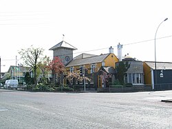 The Goat Grill | |
 Goatstown Location in Dublin | |
| Coordinates: 53°17′35″N 6°13′48″W / 53.293°N 6.230°WCoordinates: 53°17′35″N 6°13′48″W / 53.293°N 6.230°W | |
| Country | Ireland |
| Province | Leinster |
| County | Dún Laoghaire–Rathdown |
| Time zone | UTC+0 (WET) |
| • Summer (DST) | UTC-1 (IST (WEST)) |
| Eircode routing key | D14 |
| Telephone area code | +353(0)1 |

Goatstown (Irish: Baile na nGabhar) is a small Southside suburb of Dublin, Ireland. To the west is Dundrum, to the east is Blackrock, to the south is Sandyford, and to the north Ranelagh. It is mainly a residential area, with a primary school called Our Lady’s Grove, and two all girls secondary schools, Mount Anville and Jesus and Mary. There are great amenities such as restaurants, a pub, a post office and various shops.
Nature[]
Goatstown is primarily a residential area, with extensive housing developments from the middle decades of the 20th century onwards, with little local industry. It is roughly centred on a pub named the Goat Grill, at the intersection of Goatstown Road and Taney Road, where there has been a pub since the early 18th century.
Etymology[]
Goatstown got its name from the fact that formerly goats were bred there; in the 19th century it was popular to travel to Dundrum and nearby Goatstown as goat's milk was considered to be excellent for those suffering from tuberculosis.[1][2]
Transport[]
A number of roads pass through Goatstown. At the crossroads the R112 passes from west (Taney Road) to east (Mount Anville Road), to the south is the R825 (Goatstown Road) and to the north is the R133 (Lower Kilmacud Road). A short distance from the crossroads is a T-junction where the R826 terminates at the R112 on the Taney Road.
The Luas green line runs through the southwest corner of Goatstown and the Dundrum Luas stop is nearby, with the vehicular entrance off Taney Road.
The bus routes of the 11, 11a and 75 run through Goatstown as well, linking Goatstown to the city centre, Dún Laoghaire and Tallaght.
Development[]
To the east of the Goatstown Road lies former allotment land, much of which was compulsorily purchased during the 1960s for the proposed Eastern Bypass / Saint Helen's link road. A portion of this land is currently being built on by Dún Laoghaire–Rathdown County Council, to provide social and affordable housing.[citation needed]
A Georgian house and remaining surrounding land, known as Trimbleston, was sold in the early 1990s to builders Sorohan Brothers. The house was subsequently damaged in two fires and the remaining ruins demolished and replaced by a housing and apartment development, also called Trimbleston. Phase two of Trimbleston has recently commenced with the demolition of five two-storey houses on Goatstown Road and construction of 202 dwelling units in their place and on land to the east owned by the Sorohans.
Notable people[]
- William Dargan lived for a time in Mount Anville House in Goatstown. The award-winning cable-stay Luas bridge at Taney Junction was named Dargan Bridge.[3]
- Barry Desmond, politician
- David Kelly, Irish actor, resided in the town till his death in 2012
- Paul Murphy, politician
- Brian O'Driscoll, former Irish rugby player
- Shane Ross, politician, born here
Notable events[]
Charlie Chawke, who took over the local pub in 1982 and changed the name from Traynor's to the Goat Grill, was shot in the leg in October 2003 in a robbery and had his right leg amputated five days later.[4]
In another widely publicised case, on 5 March 2008 a jury found Brian Kearney guilty of the murder of his wife, Siobhán Kearney, at their home in Cnoc na Sí, Goatstown in February 2006.[5]
See also[]
- List of towns and villages in Ireland
References[]
- ^ Se n S illeabh in (1967), Irish folk custom and belief, Published for the Cultural Relations Committee of Ireland at the Three Candles, p. 24
- ^ Royal Medical and Chirurgical Society of London (1902), The Climates and baths of Great Britain, Volume 2, Macmillan, p. 415
- ^ William Dargan, Famous People of Ireland
- ^ "Chawke gives evidence in robbery trial". RTÉ News. 2006-06-20. Retrieved 2008-03-23.
- ^ "Brian Kearney given life sentence for murder of Siobhán". Irish Independent. 2008-03-05. Retrieved 2009-04-01.
External[]
County Council Map for proposed Goatstown Local Area Plan
| show Places in Dún Laoghaire–Rathdown |
|---|

- Places in Dún Laoghaire–Rathdown