East London
This article needs additional citations for verification. (February 2021) |


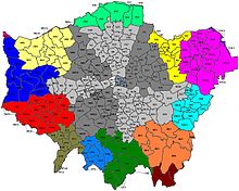
East London is a popularly and informally defined part of London, capital of the United Kingdom. By most definitions, it is east of the ancient City of London and north of the River Thames. It broadly comprises the London boroughs of Barking and Dagenham, Hackney, Havering, Newham, Redbridge, Tower Hamlets and Waltham Forest. This understanding accords closely, but not exactly, with the interpretation of the area consisting of the former Tower Division, and London east of the Lea. The East End of London is a subset of East London, consisting of areas close to the ancient City of London. The Eastern (E) Postal District is a different subset of East London; and there is also an "East" sub-region used in the London Plan for planning policy reporting purposes. The most recent (2011) iteration includes seven boroughs north of the Thames, with the addition of three boroughs south of the river.
Geography[]
Limits and extent[]
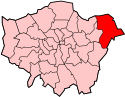
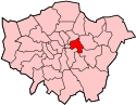
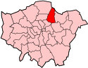
East London usually understood to be the part of Greater London east of the City of London and north of the River Thames which corresponds to the following boroughs:
| Borough | Barking and Dagenham | Hackney | Havering | Newham | Redbridge | Tower Hamlets | Waltham Forest |
|---|---|---|---|---|---|---|---|
| Location | 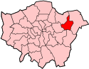 |
 |
 |
 |
 |
 |
|
| County | Greater London | Greater London | Greater London | Greater London | Greater London | Greater London | Greater London |
| London Assembly constituency | City and East | North East | Havering and Redbridge | City and East | Havering and Redbridge | City and East | North East |
| Inner/Outer London | Outer | Inner | Outer | Outer [1][notes 1] | Outer | Inner | Outer |
| Major centres[notes 2] | Barking | Dalston | Romford | Stratford | Ilford | Canary Wharf | Walthamstow |
| Population (2011) | 212,906 (2019)[2] | 246,300 | 237,200 | 308,000 | 279,000 | 254,100 | 258,200 |
E postal district[]
The E (Eastern) postcode area was introduced in 1857 to facilitate the distribution of mail. The postcode area is a sub-set of East London, with notable exclusions:
- Central areas covered by central London EC postcodes.
- Hoxton in Shoreditch which is part of the N postcode area.
- The West Hackney, De Beauvoir Town and Stamford Hill areas of Hackney proper. These are also part of the N postcode area.
- The eastern suburbs built after the introduction of the E postcode area and which are now mainly in the IG and RM post code areas.
Planning Policy Sub-region[]
The 2011 iteration of the London Plan included an altered ‘East’ region, to be used for planning, engagement, resource allocation and progress reporting purposes. As well as seven boroughs north of the river, the ‘East’ sub-region also includes three boroughs to the south of it: Greenwich, Bexley and Lewisham. These boroughs are seldom called 'east London' as they are south of the river and are poorly connected to the north.
Physical geography[]
East London is located in the lower Thames valley. The major rivers of East London are the Thames that forms the southern boundary; the Lea which forms the boundary of Tower Hamlets/Hackney with Newham/Waltham Forest; the Roding which approximately forms the boundary of Newham with Barking and Dagenham/Redbridge; and the Beam which forms the boundary of Barking and Dagenham with Havering. The marshes along the Thames which once stretched from Wapping to Rainham are almost completely gone.[3] East London is generally the lowest elevated of London's four cardinal points because of the wide Thames that runs here; the only hills here are in northern areas distant from the river in the boroughs of Havering, Redbridge and Waltham Forest.
History[]
Emergence[]
The East End, the old core of modern East London, began with the medieval growth of London beyond the city walls, along the Roman roads leading from Bishopsgate and Aldgate, and also along the river.
Growth was much slower in the east, and the modest extensions there were separated from the much larger suburbs in the west by the marshy open area of Moorfields adjacent to the wall on the north side, which discouraged development in that direction. Urbanisation accelerated in the 16th century and the area that would later become known as the East End began to take shape.
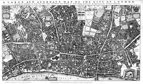
The first known written record of the East End as a distinct entity, as opposed to its component parts, comes from John Strype's 1720 'Survey of London', where he describes London as consisting of four parts: the City of London, Westminster, Southwark, and That Part beyond the Tower.
The relevance of Strype's reference to the Tower was more than geographical. The East End was the urbanised part of an area called the Tower Division, which had owed military service to the Tower of London since time immemorial. Later, as London grew further, the fully urbanised Tower Division became a byword for wider East London, before East London grew further still, east of the Lea and into Essex.
The westernmost component of the Tower Division was the ancient parish of Shoreditch, which would become fully urbanised as part of the East End/East London. Shoreditch's boundary with the parish of St Luke's (which, like its predecessor St Giles-without-Cripplegate served the Finsbury area[4]) ran through the Moorfields countryside. These boundaries remained consistent after urbanisation and so might be said to delineate east and north London. The boundary line, with very slight modifications, has also become the boundary between the modern London Boroughs of Hackney and Islington.
Moorfields remained largely open until 1812, and the longstanding presence of that open space separating the emerging East End from the western urban expansion of London must have helped shape the varying economic character of the two parts and perceptions of their distinct identity (see map below).
Growth[]
Until about 1700, London did not extend far beyond the walled boundaries of the City of London. However, the population in the parishes to the east of the City was rising and this led to a need to break up the large ancient parish of Stepney into smaller units to provide adequate religious and civil administration. It was the industries associated with the River Thames, such as shipbuilding and the docks, that encouraged growth in the east, and by 1650, Shadwell was a developed maritime settlement.[5] The docks in Tower Hamlets started to reach capacity in the early 19th century, and in 1855 the Royal Victoria Dock was opened in Newham. By 1882, Walter Besant and others, were able to describe East London as a city in its own right, on account of its large size and social disengagement from the rest of London.[6]
These industries declined in the later part of the 20th century (and earlier), but East London is now an area of regeneration. In the London Docklands, this has reached an advanced stage, but in the sections of East London that are within the Thames Gateway it is continuing, such as the redevelopment in Stratford associated with the 2012 Summer Olympics.
Areas further east developed in the Victorian and Edwardian eras after the expansion of the railways in the 19th century. Development of suburban houses for private sale was later matched by the provision of large-scale social housing at Becontree in the 1920s and Harold Hill after the Second World War. However, the urban footprint was constrained in 1878 by the protection of Epping Forest and later the implementation of the Metropolitan Green Belt. The density of development increased during the interwar period, and new industries developed, such as Ford at Dagenham. In Tower Hamlets, the population peaked in 1891 and growth was restricted to the outer boroughs. By 1971, the population had peaked in every borough and the population was declining throughout the entire area. By the time of the 2011 UK Census, this had reversed and every borough had undergone some growth in population.
The population change between 1801 and 2001 was as follows:[7][8][9][10][11][12][13]
| Borough | Barking and Dagenham | Hackney | Havering | Newham | Redbridge | Tower Hamlets | Waltham Forest |
|---|---|---|---|---|---|---|---|
| Location | |
|
|
|
|
|
|
| Population (2001) | 165,700 | 207,200 | 224,700 | 249,500 | 241,900 | 201,100 | 222,000 |
| Population (1901) | 25,080 | 374,132 | 24,853 | 338,506 | 77,621 | 578,143 | 154,146 |
| Population (1801) | 1,937 | 14,609 | 6,370 | 8,875 | 4,909 | 130,871 | 6,500 |
| Population peak | 168,724 (1951) | 379,120 (1911) | 248,107 (1971) | 454,096 (1931) | 270,876 (1951) | 584,936 (1891) | 280,094 (1931) |
Toponymy[]
The etymology of London is uncertain, but is known to be an ancient name.[14] The concept of East London as a distinct area is a relatively recent innovation. John Strype's map of 1720 describes London as consisting of four parts: The City of London, Westminster, Southwark and "That Part Beyond the Tower".[5] From the late 19th century the term East End of London was used to describe areas immediately adjacent to the City[14] in the Tower division of Middlesex. Charles Booth in 1889 defined East London as the County of London between the City and the River Lea.[15] In 1902 he now considered this area to be the "true East End", and his attention had been drawn eastward over the Lea into the Borough of West Ham, which was then outside London, and geographically in Essex, but under the authority of neither; in 1857 Charles Dickens termed it "London-over-the-Border". Walter Besant described East London as an area north of the Thames and east of the City that stretched as far as Chingford and Epping Forest,[16] which was similar to the definition used by Robert Sinclair in 1950 that stretched east to include Barking and Dagenham.[17] This broadly matched the Metropolitan Police District east of the city and north of the Thames at that time, and now corresponds to the boroughs of Barking and Dagenham, Hackney, Havering, Newham, Redbridge, Tower Hamlets and Waltham Forest in Greater London.
The area adjacent to the City of London is known as the East End of London. It does not have clearly defined boundaries, but is usually taken to be north of the River Thames, east of the City and west of the River Lea.
Economy[]
River crossings[]
The City and West London are connected to South London by more than thirty bridges, but East London is only connected by Tower Bridge at its innermost edge. The reasons for this include the widening of the Thames as it gets further east, and also the need, until relatively recently, to avoid impediments to the river traffic of the strategic London Docklands.
Until the end of the 20th century the East was connected to the South by just one railway line, the East London Line. The Jubilee Line Extension opened in 1999, was supplemented by extensions to the DLR and will eventually be joined by Crossrail. A cable car service opened in 2012.
There are road tunnels at Rotherhithe and Blackwall, with the Woolwich Ferry further east. There are also foot tunnels to Greenwich and Woolwich.
Railways[]
The majority of the rail network in East London was built within fifty years from 1839. The first through the area was the Eastern Counties Railway from Mile End to Romford, extended to Shoreditch in 1840.[18] The London and Blackwall Railway built a line from Minories to Blackwall the same year and the Northern and Eastern Railway connected Lea Bridge and Tottenham with the Eastern Counties at Stratford. The Eastern Counties and Thames Junction Railway started passenger service on their line from Stratford to Canning Town, Custom House and North Woolwich in 1847.[19] This made Stratford a significant railway junction and location of railway works. The East & West India Docks & Birmingham Junction Railway connected Kingsland with Bow and Poplar in 1850 and was renamed North London Railway in 1853.[20]
In 1854 the London, Tilbury and Southend Railway connected Forest Gate on the Eastern Counties with Barking and Rainham. The East London Railway was opened in 1869. The Great Eastern Railway connected Lea Bridge with Walthamstow in 1870, and in 1872 built a connection from the Eastern Counties line at Bethnal Green to Hackney Downs. This was connected to the Walthamstow line in 1873 and extended to Chingford. The London and Blackwall built an extension to Millwall and North Greenwich on the Isle of Dogs in 1872 and the Eastern Counties and Thames Junction Railway was extended to Beckton in 1873, and Gallions in 1880. The London, Tilbury and Southend Railway connected Barking with Dagenham, Hornchurch and Upminster in 1885,[21] and Romford with Upminster in 1893.[22] The final piece of original railway works was the construction of the Great Eastern loop line to connect Woodford with Ilford via Fairlop in 1903.
Redevelopment[]
London Docklands was defined in the 1980s as the area of redevelopment under the control of the London Docklands Development Corporation. The Thames Gateway extends into East London with two areas of activity: the Lower Lea Valley around the Olympic site and London Riverside adjacent to the Thames.
Media[]
Radio station[]
2013 saw the formation of a new "not for profit" radio station – East London Radio, which for the first time gave the whole area its own radio station for the whole community, broadcasting online at www.eastlondonradio.org.uk and run by East London Radio C.I.C. An important part of their activity is training people of all ages, from all backgrounds, in making radio programmes. In the first 12 months they trained around 60 people from the area in making talk radio programmes, and produced over 300 recorded programmes. They plan to grow from an initial community base in Hackney to have local studios in each of the East London boroughs, making volunteering and training very accessible and local for the whole community. A key aim is to give East London a voice in the post-Olympics world.
See also[]
Notes[]
- ^ Inner London for statistics
- ^ Metropolitan and major centres in the London Plan
References[]
- ^ "List of inner/outer London boroughs | London Councils". www.londoncouncils.gov.uk. Retrieved 1 April 2018.
- ^ "Population and demographic data | LBBD".
- ^ Nikolaus Pevsner (2005). London 5: East.
- ^ Records of St Giles Cripplegate, Chapter 6 https://archive.org/stream/recordsstgilesc01dentgoog/recordsstgilesc01dentgoog_djvu.txt
- ^ a b John Marriott (2011). Beyond the Tower: A History of East London.
- ^ All Sorts and Conditions of Men, Walter Besant 1882.
- ^ "Barking and Dagenham". Retrieved 6 October 2012.
- ^ "Hackney District: Total Population". A Vision of Britain Through Time.
- ^ "Havering District: Total Population". A Vision of Britain Through Time.
- ^ "Newham". Retrieved 6 October 2012.
- ^ "Redbridge". Retrieved 6 October 2012.
- ^ "Tower Hamlets". Retrieved 6 October 2012.
- ^ "Waltham Forest". Retrieved 6 October 2012.
- ^ a b Anthony David Mills (2001). Oxford Dictionary of London Place Names. Oxford University Press. ISBN 0-19-280106-6. Retrieved 15 December 2013.
- ^ Descriptive Map of London Poverty, Charles Booth, 1889
- ^ East London, Sir Walter Besant, Century Company, 1901
- ^ East London: The east and north-east boroughs of London and Greater London (County book series), Robert Sinclair, 1950
- ^ T. F. T. Baker (ed.) (1998). "A History of the County of Middlesex: Volume 11 – Stepney, Bethnal Green". Retrieved 7 October 2012.CS1 maint: extra text: authors list (link)
- ^ W. R. Powell (ed.) (1973). "A History of the County of Essex: Volume 6". Retrieved 7 October 2012.CS1 maint: extra text: authors list (link)
- ^ T. F. T. Baker (ed.) (1995). "A History of the County of Middlesex: Volume 10 – Hackney". Retrieved 7 October 2012.CS1 maint: extra text: authors list (link)
- ^ W. R. Powell (ed.) (1966). "A History of the County of Essex: Volume 5". Retrieved 7 October 2012.CS1 maint: extra text: authors list (link)
- ^ W. R. Powell (ed.) (1978). "A History of the County of Essex: Volume 7". Retrieved 7 October 2012.CS1 maint: extra text: authors list (link)
External links[]
 East London travel guide from Wikivoyage
- Rooms in East London

- Areas of London
- Geography of the London Borough of Barking and Dagenham
- Geography of the London Borough of Hackney
- Geography of the London Borough of Havering
- Geography of London
- Geography of the London Borough of Newham
- Geography of the London Borough of Tower Hamlets
- Geography of the London Borough of Waltham Forest
- London sub-regions