Ilford
| Ilford | |
|---|---|
 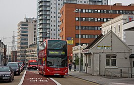 From top to bottom: Redbridge Town Hall on Ilford High Road; Ilford Hill | |
 Ilford Location within Greater London | |
| Population | 168,168 (2011 Census)[1] |
| OS grid reference | TQ445865 |
| • Charing Cross | 9.0 mi (14.5 km) WSW |
| London borough |
|
| Ceremonial county | Greater London |
| Region |
|
| Country | England |
| Sovereign state | United Kingdom |
| Post town | ILFORD |
| Postcode district | IG1-IG6 |
| Dialling code | 020 |
| Police | Metropolitan |
| Fire | London |
| Ambulance | London |
| UK Parliament | |
| London Assembly | |

Ilford is a large town in east London, England, located in the ceremonial county of Greater London. Identified as a metropolitan centre in the London Plan, Ilford is classed as a significant commercial and retail centre for the wider south east of England. It had a population of 168,168 in 2011, compared to 303,858 for the entire borough.
Ilford's commercial and retail centre is surrounded by extensive residential development. Historically a small rural settlement in the ancient parish of Barking in the Becontree hundred of Essex, its strategic position on the River Roding and the London to Colchester road made it a coaching town.[2] The arrival of the railway in 1839 accelerated its growth, leading to the area becoming a suburb of and part of the conurbation of London. It split from the parish of Barking in 1888, and, in the 20th century, Ilford significantly expanded and increased in population, becoming a municipal borough in 1926. Since 1965 it has formed part of the London Borough of Redbridge, a local government district of Greater London.
Ilford is on the transport corridor between London and coastal Essex, with both the A12 and the central railway station linking the regions. The town centre of Ilford is the head district of the IG postcode area. Adjacent to Ilford; to the west of Ilford Hill and the North Circular Road, is the E postcode area. In recent years, as a result of increased levels of immigration, Ilford has become one of the most multicultural towns in England.
Origins and administration[]
Toponymy[]
Ilford was historically known as Great Ilford to differentiate it from nearby Little Ilford.[3] The name is first recorded in the Domesday Book of 1086 as Ilefort and means "ford over the Hyle". "Hyle" is an old name for the River Roding that means "trickling stream". Great and Little Ilford share the place name origin,[3] but the Domesday reference is to the Little Ilford area.[4]
Great and Little Ilford appear to have always been distinct areas separated by the Roding. The place names of Great and Little Ilford both appear to derive from the ford (and river), rather than deriving from the subdivision of a larger Ilford area.
Manor of Barking[]
Barking was a huge Manor (landholding), first mentioned in a charter in 735 AD. The Manor covered the areas now known as Barking, Dagenham and Ilford. The Manor was held by the Nunnery of Barking Abbey.
Ancient Parish of Barking[]
By the late 1100s (the Parishes of England were, with a few exceptions, fixed for around 700 years from the late 12th century onwards[5]) the huge Manor of Barking was served by two Ancient Parishes, Barking (including Ilford) and Dagenham. This reversed the usual situation (for smaller, and even quite large Manors) where a parish would serve one or more manors. As with other manors, the area held by the declined over time, but the parish boundaries based on its former extent remained constant.
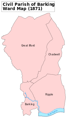
The Parish of Barking, in the Becontree hundred of Essex, covered the areas now known as Barking and Ilford. Barking was a large ancient parish of 12,307 acres (49.80 km2) in the Becontree hundred of Essex. It was divided into the wards of Chadwell, Great Ilford, Ripple and Town.
Ilford separates from Barking[]
The Barking parish authorities gradually lost responsibility for a variety of functions during the 19th century; from 1836, for the administration of poor relief, Ilford came within the Romford Poor Law Union and in 1840 the Metropolitan Police District was extended to cover the area. In 1875, the Romford rural sanitary district was created, covering a wide area including Ilford.
In 1888, Ilford and the neighbouring ward of Chadwell to east were split from Barking and together formed a separate Ilford civil parish and also a new Urban District Council. In 1890, a local board of health was set up for the parish, replacing the rural sanitary authority, and in 1894 a reform of local government reconstituted it as an urban district. It formed part of the London Traffic Area from 1924 and the London Passenger Transport Area from 1933.[6] It was incorporated as the Municipal Borough of Ilford in 1926.[7]
The suburban expansion of London caused a significant increase in population and the borough became one of the largest in England not to gain county borough status.
London Borough of Redbridge[]
In 1965, the municipal borough was abolished and its former area was combined with that of Wanstead and Woodford, the northern extremity of Dagenham and a small part Chigwell Urban District (around Hainault), to form the new London Borough of Redbridge.
Representation[]
Ilford is divided between the UK Parliament constituencies of Ilford North and Ilford South. Ilford North consists of the Redbridge wards of Aldborough, Barkingside, Redbridge, Clayhall, Fairlop, Fullwell, Hainault and Roding. The Member of Parliament (MP) is Wes Streeting of the Labour Party, who succeeded the previous MP Lee Scott of the Conservative Party in the 2015 general election. Ilford South corresponds to the Redbridge wards of Chadwell, Clementswood, Cranbrook, Goodmayes, Loxford, Mayfield, Newbury, Seven Kings, and Valentines. The MP is Sam Tarry of the Labour Party. Ilford forms part of the Havering and Redbridge London Assembly constituency.
History[]
Pre-historic natural history[]
The only complete skull of a mammoth discovered in the United Kingdom was unearthed in 1864 close to where Uphall Road is today. The skull can now be seen in the Natural History Museum and a cast of the skull and other prehistoric animal remains can be seen at Redbridge Museum, Central Library, Ilford.
Iron Age[]
Redevelopment has destroyed much of the evidence for early Ilford, but the oldest evidence for human occupation is the 1st- and 2nd-century BC Iron Age earthwork known as Uphall Camp. This was situated between the Roding and Ilford Lane and is recorded in 18th-century plans.[2] Roman finds have also been made in the vicinity.[8]
Lavender Mount[]
A nearby mound called Lavender Mount existed into the 1960s, when it was removed during building work at Howards chemical works. Excavation has shown that Lavender Mount may have been a 16th-century 'beacon-mound'. Archaeological discoveries are displayed at Redbridge Museum.[9]
Economic development[]


Ilford straddled the important road from London to Colchester. The Middlesex and Essex Turnpike Trust controlled and maintained the road from 1721. The River Roding was made navigable for barges as far as Ilford Bridge from 1737.[8] Ilford remained largely rural until its expansion in the 19th century. This brought about brickworks, cement works and coal yards to service the new buildings, largely centred on the River Roding. In 1839, a railway station was opened on the line from Romford to Mile End. The early businesses gave way to new industries, such as paper making and services such as steam laundries and collar making, to provide for the new commuting class created by the railway. A number of major businesses have been founded in the town, including the eponymous photographic film and chemicals manufacturer Ilford Photo.[10] This was founded in 1879 by Alfred H. Harman, a photographer from Peckham, who established the business in a house in Cranbrook Road making gelatino-bromide 'dry' plates.[2] The business soon outgrew these premises, and its headquarters moved to a site at Roden Street until 1976 when the factory was closed. Many Ilford Limited products are displayed at Redbridge Museum.[9]
The radio, electronics and telecommunications company Plessey, founded in 1917 in Marylebone, moved to Cottenham Road in Ilford early in 1919 and then to Vicarage Lane where became one of the largest manufacturers in its field. During World War II, the factory was heavily damaged by bombing and the company carried out much of its manufacture, with 2,000 workers servicing a production line, located in the underground railway tunnel between Wanstead and Gants Hill.[2] In 1955 the company employed 15,000 workers, in sites throughout Ilford and neighbouring areas, with an extensive research department.[2] BAL-AMi Jukeboxes were manufactured at 290–296 High Road, Ilford, during the 1950s, which also served as the headquarters of the Balfour (Marine) Engineering company.[11] The Exchange is the main shopping centre.

Suburban expansion[]

By 1653, Ilford was a compact village of 50 houses, mostly sited north and south of the current Broadway[2] and the area was distinctly rural. In 1801 the population of Ilford was 1,724 and by 1841 it had grown to 3,742.[2] It had a population of 41,244 in 1901 and occupied an area of 8,496 acres (34 km2). 2,500 houses of the vast Becontree Estate, built by the London County Council from 1921, were within the boundaries of Ilford; the addition caused a rise in population of 11,600 by 1926.[2] The Central line service of the London Underground to new and former main-line stations in the area began in 1947[12] and the population of the Municipal Borough of Ilford peaked in 1951 at 184,706, declining to 178,024 in 1961 before being absorbed into Redbridge and Greater London in 1965. At the 2001 Census the combined populations of the Ilford North and Ilford South constituencies was 196,414.[13][14]
Notable events[]
John Logie Baird, who invented the television, moved to Ilford in the mid to late 1920s to work on his new invention. He worked in a workshop on the roof of the Plessey premises in Ley Street, which has long since been demolished to make way for new housing.
Ilford was also the birthplace of the actor Maggie Smith who left to Oxford at the age of four.
During World War II an Ilford man lost his life when his Royal Air Force training airplane crashed in the United States. Local residents living near the site, in the State of Oklahoma, erected a monument in 2000 honoring the lives of all four RAF fliers who perished. The event was attended by the Lord Mayor of Ilford and his Mace Bearer, to much local acclaim. The residents, who include Choctaw Indians and the Choctaw Nation government, continue honoring the lives of all four on each anniversary of the crashes, which took place in February 1943.[15]
Olympics[]
Its proximity to the Olympic Park in Stratford meant that in 2011, Ilford was the fastest-growing tourist destination in Europe due to the London 2012 Summer Olympics.[16]
Economy[]
In 2005, Ilford was ranked 6th in the Retail Footprint ranking for Greater London, behind London's West End, Croydon, Kingston upon Thames, Bromley and Brent Cross Shopping Centre. It ranked just above Romford and central London's Kensington.[17] As of 2020, Ilford has 145,860 square metres (1,570,000 sq ft) of total town centre floorspace, the 10th highest in Greater London and noticeably lower compared to Stratford and Romford.[18]
Geography[]
Ilford is bounded in the west by the North Circular Road and the River Roding and is contiguous with Barking to the south, Gants Hill and Barkingside to the north and Seven Kings to the east. The Alders Brook is a tributary of the Roding that marks the boundary between Newham and Redbridge. Climate data for Ilford is taken from the nearest weather station at Greenwich, around 6 miles (9.7 km) south south west of the railway station:
| hideClimate data for Greenwich Park, elevation: 47 m (154 ft), 1981–2010 normals | |||||||||||||
|---|---|---|---|---|---|---|---|---|---|---|---|---|---|
| Month | Jan | Feb | Mar | Apr | May | Jun | Jul | Aug | Sep | Oct | Nov | Dec | Year |
| Record high °C (°F) | 14.4 (57.9) |
19.7 (67.5) |
21.7 (71.1) |
25.6 (78.1) |
30.0 (86.0) |
32.8 (91.0) |
35.3 (95.5) |
37.5 (99.5) |
30.0 (86.0) |
25.6 (78.1) |
18.9 (66.0) |
15.0 (59.0) |
37.5 (99.5) |
| Average high °C (°F) | 8.1 (46.6) |
8.6 (47.5) |
11.6 (52.9) |
14.6 (58.3) |
18.1 (64.6) |
21.0 (69.8) |
23.4 (74.1) |
23.1 (73.6) |
20.0 (68.0) |
15.5 (59.9) |
11.3 (52.3) |
8.4 (47.1) |
15.3 (59.5) |
| Daily mean °C (°F) | 5.6 (42.1) |
5.7 (42.3) |
8.1 (46.6) |
10.3 (50.5) |
13.5 (56.3) |
16.4 (61.5) |
18.6 (65.5) |
18.5 (65.3) |
15.7 (60.3) |
12.2 (54.0) |
8.6 (47.5) |
5.9 (42.6) |
11.6 (52.9) |
| Average low °C (°F) | 3.1 (37.6) |
2.7 (36.9) |
4.6 (40.3) |
5.9 (42.6) |
8.9 (48.0) |
11.8 (53.2) |
13.7 (56.7) |
13.8 (56.8) |
11.4 (52.5) |
8.8 (47.8) |
5.8 (42.4) |
3.4 (38.1) |
7.8 (46.0) |
| Record low °C (°F) | −9.4 (15.1) |
−9.4 (15.1) |
−7.8 (18.0) |
−2.2 (28.0) |
−1.1 (30.0) |
5.0 (41.0) |
7.2 (45.0) |
6.1 (43.0) |
2.8 (37.0) |
−3.3 (26.1) |
−5.0 (23.0) |
−7.2 (19.0) |
−9.4 (15.1) |
| Average precipitation mm (inches) | 41.6 (1.64) |
36.3 (1.43) |
40.3 (1.59) |
40.1 (1.58) |
44.9 (1.77) |
47.4 (1.87) |
34.6 (1.36) |
54.3 (2.14) |
51.0 (2.01) |
61.1 (2.41) |
57.5 (2.26) |
48.4 (1.91) |
557.4 (21.94) |
| Average precipitation days (≥ 1.0 mm) | 11.4 | 8.5 | 9.8 | 9.0 | 9.2 | 7.4 | 6.3 | 8.1 | 8.6 | 10.9 | 10.9 | 9.5 | 109.4 |
| Mean monthly sunshine hours | 44.7 | 65.4 | 101.7 | 148.3 | 170.9 | 171.4 | 176.7 | 186.1 | 133.9 | 105.4 | 59.6 | 45.8 | 1,410 |
| Source 1: Met Office[19][20][21] | |||||||||||||
| Source 2: BBC Weather[22] | |||||||||||||
Demography[]
Historic population statistics[]
| 1891 | 10,913 |
|---|---|
| 1901 | 41,234 |
| 1911 | 78,188 |
| 1921 | 85,194 |
| 1931 | 131,061 |
| 1941 | # |
| 1951 | 184,706 |
| 1961 | 178,024 |
| # no census was held due to war | |
| source: UK census[23] | |
Population[]
The entire town of Ilford is also made up of its neighbourhoods Aldborough Hatch, Barkingside, Clayhall, Cranbrook, Fairlop, Fullwell Cross, Loxford, Gants Hill, Goodmayes, Newbury Park, Redbridge and Seven Kings. It approximates to 11 electoral wards, and the total population counted 168,168 people in the 2011 census, compared to 303,858 for the borough of Redbridge as a whole.[24]
Ethnicity[]
Ilford has a very large ethnic-minority population, one of the most diverse towns in the country.[25]
Ilford North had the fourth-highest Jewish proportion of residents in the 2001 census.[13] The Hindu, Muslim and Sikh population number some 30,000.[26] The large South Asian community in Ilford speak a variety of languages, including Bengali, Gujarati, Hindi, Punjabi, Tamil, Telugu and Urdu.[27]
According to the 2001 census, the parliamentary constituencies of Ilford North and Ilford South consisted of the following demographs:
| Ilford North | Ilford South | |
|---|---|---|
| Total Population | 89,806 | 106,608 |
| White | 60.6% | 40.1% |
| Black | 20.2% | 29.4% |
| Asian | 15.5% | 30.3% |
| Mixed | 2.2% | 2.8% |
| Other | 1.5% | 0.4% |
| Ilford North | Ilford South | |
|---|---|---|
| Christian | 55.1% | 42.5% |
| Hindu | 6.7% | 10.5% |
| Jewish | 10.3% | 7.9% |
| Muslim | 6.4% | 19.6% |
| Sikh | 2.7% | 9.4% |
At the 2011 census, the Clementswood ward's population with a BAME (Black, Asian and minority ethnic) background was 84.2%, one of the highest in Greater London. Most of Ilford's other wards have figures above 70%. The lowest BAME ward in Ilford was Fairlop, 34.9%.[28]
Housing[]
House prices in Ilford are generally far lower compared to the average in Greater London. The median house price in 2014 in Ilford's Loxford ward was £193,000, which was the 6th lowest out of the 628 wards of Greater London.[28]
In most wards, a majority of houses are owned by the households. The exceptions are in Clementswood, Loxford, and Valentines.[28]
The table below shows housing type data for Ilford's wards as of the 2011 census (but altered to match new ward boundaries as of 2015).
| Ward | Detached | Semi-detached | Terraced | Flats and apartments[29][30] |
|---|---|---|---|---|
| Aldborough | 4.9% | 25.1% | 43.5% | 26.6% |
| Barkingside | 4.2% | 31.5% | 40.2% | 24.1% |
| Clayhall | 7.2% | 48.7% | 30.4% | 13.6% |
| Clementswood | 7.7% | 12.4% | 45.0% | 34.9% |
| Cranbrook | 3.5% | 27.8% | 39.7% | 28.9% |
| Fairlop | 7.4% | 28.8% | 37.7% | 26.2% |
| Fullwell | 7.6% | 43.7% | 21.9% | 26.8% |
| Goodmayes | 6.3% | 22.1% | 42.2% | 29.3% |
| Loxford | 2.9% | 12.2% | 42.8% | 36.0% |
| Mayfield | 10.8% | 26.6% | 47.3% | 15.3% |
| Newbury | 4.5% | 17.8% | 48.2% | 29.3% |
| Seven Kings | 6.1% | 20.4% | 42.9% | 30.5% |
| Valentines | 4.7% | 13.1% | 31.6% | 50.5% |
Other[]
The male life expectancy was 76.4 years in Loxford, and 84.5 years in Barkingside. The female expectancy was highest in Barkingside, 87.5 years, and lowest in Loxford, 81.7 years.[28]
Transport[]

The town centre is served by Ilford railway station on the Great Eastern Main Line in Travelcard Zone 4.[31] All trains calling at the station are the high-frequency Liverpool Street-Shenfield metro service. This service was taken over by TfL Rail on 31 May 2015 as part of preparations for the arrival of Crossrail in 2020/21.[32] The station was the scene of crashes in 1915 and 1944 that killed 10 and 9 people respectively. To the east is Ilford EMU Depot, a traction maintenance depot on the Great Eastern Main Line, operated by Greater Anglia.
There are two other local stations on the same line with less frequent trains: Seven Kings railway station and Goodmayes railway station.
The Central line of London Underground serves neighbourhoods of Ilford via Redbridge, Gants Hill, Newbury Park, Barkingside and Fairlop tube stations. The line passes through the northern half of the district with no stations in the town centre. Gants Hill is the closest, being about 1 mile to the north of Ilford railway station. Arguably due to its proximity to the town centre, it is also the busiest of these stations, recording 6.5 million entries and exits in 2018.
Buses[]
Ilford is a hub of the London Buses network with services to central London (notably route 25) and various suburbs – east to Romford and as far north as Loughton and Wood Green.[33][34]
The first stage of the East London Transit begins at Ilford.[35]

Landmarks[]
Valentines Mansion was built in 1696 and was used as council offices until 1994. It gives its name to Valentines Park, the largest green space in the borough. Pioneer Point is two buildings, Pioneer Point North is 105 m tall with 33 floors and Pioneer Point South is 82 m tall with 25 floors. Raphael House is 99m, Lynton House is 93m tall and was completed in 1969.
Religious buildings[]
St Mary's Church is the original parish church, but for much of the 20th century St Clement's Church was the main Anglican church until it was demolished in 1977. St Alban's Church is a redbrick Neo-Gothic building on Albert Road. Ilford Hospital Chapel is the oldest building in Redbridge, dating back to c1140. St Luke's Church is occupied by the Mar Thoma Syrian Church.
Education[]
Loxford School in Loxford has over 3000 students from 11 to 18, Seven Kings School is half that size. Palmer Catholic Academy is a Catholic secondary school and Ursuline Academy Ilford is a Catholic school for girls. Cranbrook School was an independent school that closed in 2016. Uphall Primary School is in Loxford near the North Circular.
Culture[]

Art, theatre and media[]
The local newspaper, covering the town and the borough, is the Ilford Recorder.
The poets Kathleen Raine (1908–2003) and Denise Levertov (1923–1997) were both born and spent their early years in Ilford.[36] Levertov's Russian father, born a Hassidic Jew but converted to Christianity as a student, settled in Ilford as an Anglican minister.[37] There is a tablet memorialising Levertov's father in Ilford's Hospital Chapel.[38] Whilst Levertov wrote lyrically about Ilford, and in particular Valentines Park, in later life,[39] Raine described it as a "suburban Hades".[40]
The Kenneth More Theatre was officially opened in January 1975. It places emphasis on serving the local community, and stages a mix of professional and amateur productions. Its programme is varied, and runs throughout the year with productions generally changing on a weekly basis. It is well known within the local area for its annual pantomime, which normally runs from mid-December to mid-January.[41]
St. Alban's Singers is a mixed voice choir for men and women based in St. Alban's Church in Albert Road, Ilford. The choir meets to rehearse at the church each Tuesday evening during term-time and aims to give three concerts per year.[42]
Kathy Kirby was born in Ilford.
Sport[]
An unspecified venue in Ilford was used for a cricket match in August 1737 between Essex and London. It is the earliest known organised match definitely played in Essex.[43]
Ilford Cricket Club plays home games at Valentines Park. This ground was opened in 1897.[44] It was used regularly by Essex County Cricket Club, but inadequate maintenance meant that the county stopped playing there after 2001.[45]
Two Non-League football clubs play at the Cricklefield Stadium, Ilford F.C. of the Essex Senior League and Barkingside F.C. of the Eastern Counties League Division One South. Waltham Forest F.C. (now Walthamstow F.C.) played at the Cricklefield from 2008 to 2013.
South Park is one of the largest open spaces in the London Borough of Redbridge and has been awarded Green Flag status.[46] The Redbridge Parks Police patrolled the parks until they were disbanded in 2011.
See also[]
- List of people from Redbridge
- List of schools in Redbridge
References[]
- ^ Ilford is made up of 12 wards in the London Borough of Redbridge: Aldborough Hatch, Barkingside, Cranbrook, , Fairlop, Gants Hill, Vicarage, Loxford, , Newbury Park, Seven Kings, and Valentines. "Archived copy". Archived from the original on 22 February 2014. Retrieved 9 June 2014.CS1 maint: archived copy as title (link)
- ^ Jump up to: a b c d e f g h Powell, W.R. (Edr.) (1966). The borough of Ilford, A History of the County of Essex: Volume 5. Victoria County History. British History Online. Retrieved 28 August 2009.
- ^ Jump up to: a b Mills, A.D. (2001). Dictionary of London Place Names. Oxford.
- ^ Describing how Little Ilford was the place referred to at Domesday https://www.british-history.ac.uk/vch/essex/vol5/pp190-214
- ^ History of the Countryside by Oliver Rackham, 1986 p19
- ^ Robson, William (1939). The Government and Mis-government of London. London: Allen & Unwin.
- ^ Great Britain Historical GIS / University of Portsmouth, Ilford UD/MB (historic map). Retrieved {{{accessdate}}}.
- ^ Jump up to: a b Powell, W.R. (Edr.) (1966). The ancient parish of Barking: Introduction, A History of the County of Essex: Volume 5. Victoria County History. British History Online. Retrieved 28 August 2009.
- ^ Jump up to: a b "Redbridge Museum". Redbridge.gov.uk. Retrieved 2 March 2014.
- ^ "Ilford History and Chronology". Retrieved 27 July 2007.
- ^ "BAL-AMi Jukeboxes".
- ^ Rose, D (1999). The London Underground: A diagrammatic history.
- ^ Jump up to: a b c "UKPollingReport Election Guide 2010 » Ilford North". Retrieved 2 March 2014.
- ^ Jump up to: a b "UKPollingReport Election Guide 2010 » Ilford South". Retrieved 2 March 2014.
- ^ AT6 Monument
- ^ The Daily Telegraph (December 2011). "TripAdvisor: Ilford is Europe's fastest growing tourist destination". The Daily Telegraph.
- ^ https://web.archive.org/web/20071020003313/http://www.caci.co.uk/msd.asp?url=lsp-retailfootprint.htm[bare URL]
- ^ https://www.london.gov.uk/sites/default/files/gla_migrate_files_destination/2013%20TCHC%20report.pdf[bare URL]
- ^ "Greenwich 1981–2010 averages". Met Office. Retrieved 20 November 2018.
- ^ "Hot Spell - August 2003". Met Office. Retrieved 17 December 2018.
- ^ "Record Breaking Heat and Sunshine - July 2006". Met Office. Retrieved 17 December 2018.
- ^ "London Forecast". Met Office. Retrieved 17 December 2018.
- ^ Great Britain Historical GIS / University of Portsmouth, Ilford parish population. Retrieved {{{accessdate}}}.
- ^ "Archived copy". Archived from the original on 22 February 2014. Retrieved 9 June 2014.CS1 maint: archived copy as title (link)
- ^ https://www.redbridge.gov.uk/media/7259/ilford-manifesto.pdf[bare URL]
- ^ "South Asian Development Partnership – Research". Southasian.org.uk. Retrieved 2 March 2014.
- ^ "Setting up your business in London" (PDF). Thinklondon.com. Retrieved 2 March 2014.
- ^ Jump up to: a b c d "Ward Profiles and Atlas – London Datastore".
- ^ "Neighbourhood statistics". Office for National Statistics.
- ^ Census Information Scheme (2012). "2011 Census Ward Population Estimates". Greater London Authority. Retrieved 30 January 2013.
- ^ Transport for London (March 2009). "High frequency services" (PDF). Greater London Authority. Retrieved 28 August 2009.
- ^ National Express East Anglia (May 2009). "Table 6" (PDF). National Express. Retrieved 28 August 2009.
- ^ Transport for London (September 2007). "Buses from Ilford" (PDF). Greater London Authority. Retrieved 28 August 2009.
- ^ https://www.nationalrail.co.uk/posters/IFD.pdf[bare URL]
- ^ Transport for London. "East London Transit". Greater London Authority. Archived from the original on 8 March 2010. Retrieved 28 August 2009.
- ^ Fulton, D, 'Heaven or Hell: Representations of Ilford in the Writings of Denise Levertov and Kathleen Raine', 2010, Brunel University Research Paper.
- ^ Ann-Marie Abbasah (2016) 'Blue plaque campaign set to honour Ilford’s most famous poet', Ilford Recorder, 30 April
- ^ Ursulines.co.uk:Poetry and prayer – Denise Levertov 1923–1997
- ^ Levertov, A map of the Western Part of the County of Essex in England
- ^ Kathleen Raine, Farewell Happy Fields: Memories of Childhood (London: Hamish Hamilton, 1973)
- ^ "About us | Kenneth More Theatre". Kmtheatre.co.uk. 3 January 1975. Retrieved 26 April 2021.
- ^ "St. Alban's Singers – Choir in Ilford". stalbansingers.simdif.com.
- ^ Buckley, p. 14.
- ^ "Valentine's Park | England | Cricket Grounds". ESPN Cricinfo. Retrieved 2 March 2014.
- ^ Steen, Rob (8 September 2001). "Cricket Focus : Essex heartbreak at Valentines Park". The Daily Telegraph. London. Retrieved 2 March 2014.
- ^ Green Flag – South Park
Bibliography[]
- Buckley, G. B. (1935). Fresh Light on 18th Century Cricket. Cotterell.
- Ian Dowling Valentines Park, Ilford: A Century of History (1999) OCLC 43337735
- J E Oxley Barking and Ilford: An Extract from the Victoria History of the County of Essex vol 5 (1987)
- James Thorne (1876), "Great Ilford", Handbook to the Environs of London, London: John Murray, hdl:2027/mdp.39015063815669
- Edward Walford (1883), "Ilford", Greater London, London: Cassell & Co., OCLC 3009761
External links[]
 Media related to Ilford at Wikimedia Commons
| show London Borough of Redbridge |
|---|

| show Authority control |
|---|
- Ilford
- Areas of London
- Districts of the London Borough of Redbridge
- Metropolitan centres of London
- Business improvement districts in London