Westville, Oklahoma
Westville, Oklahoma | |
|---|---|
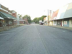 Downtown Westville north up Williams Street. The Buffington Hotel is on the left. | |
 Location within Adair County and the state of Oklahoma | |
| Coordinates: 35°59′29″N 94°34′16″W / 35.99139°N 94.57111°WCoordinates: 35°59′29″N 94°34′16″W / 35.99139°N 94.57111°W | |
| Country | |
| State | |
| County | Adair |
| Incorporated | 1920 |
| Government | |
| • Type | Weak mayor |
| • Mayor | Tony Barker |
| Area | |
| • Total | 1.21 sq mi (3.15 km2) |
| • Land | 1.21 sq mi (3.14 km2) |
| • Water | 0.00 sq mi (0.00 km2) |
| Elevation | 1,129 ft (344 m) |
| Population (2010) | |
| • Total | 1,639 |
| • Estimate (2019)[2] | 1,551 |
| • Density | 1,277.59/sq mi (493.48/km2) |
| Time zone | UTC-6 (Central) |
| • Summer (DST) | UTC-5 (Central) |
| ZIP code | 74965 |
| Area code(s) | 539/918 |
| FIPS code | 40-80450[3] |
| GNIS feature ID | 1099641[4] |

Westville is a town in Adair County, Oklahoma, United States. The population was 1,639 at the 2010 census, an increase of 2.7 percent over the figure of 1,596 recorded in 2000.[5]
History[]
Before statehood, Westville was a community in the Goingsnake District of the Cherokee Nation. The town was founded in 1895, when the Kansas City, Pittsburg and Gulf Railroad (later acquired by the Kansas City Southern Railroad) was constructing a rail line from Kansas City to the Gulf Coast. The Westville post office was established on November 18, 1895. The town name honored Jim West, who lived one mile south of nearby Cincinnati, Arkansas, and whose son, Jim West, Jr., was an attorney for the Kansas City Southern Railway.[6]
When Adair County was formed in 1907, Westville was identified as the county seat, due partly to its location at the intersection of two major railroads: the Kansas City Southern Railway and the St. Louis – San Francisco Railway.[7] The county seat was moved to Stilwell in 1910.[8]
Geography[]
Westville is located at 35°59′29″N 94°34′16″W / 35.99139°N 94.57111°W (35.991414, -94.571088).[9] It is 13 miles (21 km) north of Stilwell and 15 miles (24 km) south of Siloam Springs, Arkansas.[6]
According to the United States Census Bureau, the town has a total area of 1.2 square miles (3.1 km2), all land.
Westville is located at the intersection of U.S. Routes 59 and 62.[10]
Demographics[]
| Historical population | |||
|---|---|---|---|
| Census | Pop. | %± | |
| 1900 | 296 | — | |
| 1910 | 802 | 170.9% | |
| 1920 | 956 | 19.2% | |
| 1930 | 691 | −27.7% | |
| 1940 | 716 | 3.6% | |
| 1950 | 781 | 9.1% | |
| 1960 | 727 | −6.9% | |
| 1970 | 934 | 28.5% | |
| 1980 | 1,049 | 12.3% | |
| 1990 | 1,374 | 31.0% | |
| 2000 | 1,596 | 16.2% | |
| 2010 | 1,639 | 2.7% | |
| 2019 (est.) | 1,551 | [2] | −5.4% |
| U.S. Decennial Census[11] | |||
As of the census[3] of 2000, there were 1,596 people, 599 households, and 401 families residing in the town. The population density was 1,324.1 people per square mile (509.3/km2). There were 719 housing units at an average density of 596.5 per square mile (229.4/km2). The racial makeup of the town was 62.41% White, 0.25% African American, 28.07% Native American, 0.31% Asian, 2.63% from other races, and 6.33% from two or more races. Hispanic or Latino of any race were 6.02% of the population.
There were 599 households, out of which 36.1% had children under the age of 18 living with them, 45.9% were married couples living together, 17.5% had a female householder with no husband present, and 32.9% were non-families. 28.7% of all households were made up of individuals, and 12.0% had someone living alone who was 65 years of age or older. The average household size was 2.57 and the average family size was 3.16.
In the town, the population was spread out, with 29.9% under the age of 18, 8.3% from 18 to 24, 25.8% from 25 to 44, 20.3% from 45 to 64, and 15.7% who were 65 years of age or older. The median age was 34 years. For every 100 females, there were 87.1 males. For every 100 females age 18 and over, there were 82.4 males.
The median income for a household in the town was $22,381, and the median income for a family was $28,882. Males had a median income of $25,729 versus $20,438 for females. The per capita income for the town was $11,055. About 16.1% of families and 22.3% of the population were below the poverty line, including 24.0% of those under age 18 and 19.0% of those age 65 or over.
NRHP Sites[]
Sites in Westville listed on the National Register of Historic Places include:
- The Buffington Hotel, on Main St.
- The Rev. Jesse Bushyhead Grave, which has a 15-foot-tall (4.6 m) marble monument to the Cherokee religious and political leader, in the Baptist Mission Cemetery off State Highway 59
- The Opera Block (on Main St. but since demolished)
- The Ballard Creek Roadbed (relevant to the Cherokee Trail of Tears, address restricted)
- Breadtown (relevant to the Cherokee Trail of Tears, address restricted)
Notable people[]
- Jim Ross, World Wrestling Entertainment commentator
- Markwayne Mullin, United States House Representative for Oklahoma's 2nd District
References[]
- ^ "2019 U.S. Gazetteer Files". United States Census Bureau. Retrieved July 28, 2020.
- ^ a b "Population and Housing Unit Estimates". United States Census Bureau. May 24, 2020. Retrieved May 27, 2020.
- ^ a b "U.S. Census website". United States Census Bureau. Retrieved 2008-01-31.
- ^ "US Board on Geographic Names". United States Geological Survey. 2007-10-25. Retrieved 2008-01-31.
- ^ CensusViewer:Westville, Oklahoma Population
- ^ a b Jack D. Baker, "Westville," Encyclopedia of Oklahoma History and Culture. Accessed March 27, 2015.
- ^ Hill, Luther B. (1910). A History of the State of Oklahoma. Vol. I. The Lewis Publishing Company. p. 470.
- ^ Oklahoma Almanac Online (PDF). Oklahoma Department of Libraries. 2005.
- ^ "US Gazetteer files: 2010, 2000, and 1990". United States Census Bureau. 2011-02-12. Retrieved 2011-04-23.
- ^ Official State Map (Map) (2008 ed.). Oklahoma Department of Transportation.
- ^ "Census of Population and Housing". Census.gov. Retrieved June 4, 2015.
Municipalities and communities of Adair County, Oklahoma, United States | ||
|---|---|---|
| City |  | |
| Towns | ||
| CDPs | ||
| Other communities | ||
| Indian reservation | ||
| Footnotes | ‡This populated place also has portions in an adjacent county or counties | |
| ||
| Stilwell | ||
|---|---|---|
| Westville |
| |
- Towns in Adair County, Oklahoma
- Towns in Oklahoma