Woodenbong
| Woodenbong New South Wales | |
|---|---|
 Woodenbong | |
 Woodenbong | |
| Coordinates | 28°23′0″S 152°36′0″E / 28.38333°S 152.60000°ECoordinates: 28°23′0″S 152°36′0″E / 28.38333°S 152.60000°E |
| Population | 332 (2006 census)[1] |
| Postcode(s) | 2476 |
| Location | |
| LGA(s) | Kyogle Council |
| State electorate(s) | Lismore |
| Federal division(s) | New England, Page |

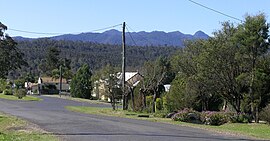
Woodenbong is a rural village in the Kyogle Shire of northern New South Wales. It is situated 10 km south of the Queensland border and five kilometres south of the junction of the Summerland Way and the Mount Lindesay Road, which leads to and eventually Tenterfield. At the 2006 census Woodenbong had a population of 332.[1]
Woodenbong is home to Woodenbong Central School, a Kindergarten - Year 12 central school, that serves as the common education centre for Woodenbong, as well as surrounding towns, Urbenville and Muli Muli. Woodenbong Central School has played host on numerous occasions to sporting events held between other rural New South Wales towns.
It is 798 km north-east of Sydney, 145 km from Brisbane and 60 km north-west of Kyogle.
The name is derived from a Githabul word meaning wood ducks on water. The Githabal (also known as Gidabal, Kitabal) language region includes the landscape within the local government boundaries in Queensland of the Southern Downs Regional Council, particularly Warwick, Killarney, and Woodenbong extending into New South Wales.[2]
Dairy farming and cattle grazing are the two main industries. A number of National Parks are close to Woodenbong, some of which are declared World Heritage areas.
- Border Ranges National Park
- Koreelah National Park
- Toonumbar National Park
- Mount Warning National Park
- Lamington National Park
- Mount Barney National Park
- Springbrook National Park
References[]
- ^ a b Australian Bureau of Statistics (25 October 2007). "Woodenbong (L) (Urban Centre/Locality)". 2006 Census QuickStats. Retrieved 2 March 2010.
- ^
 This Wikipedia article incorporates CC-BY-4.0 licensed text from: "Githabul". Queensland Aboriginal and Torres Strait Islander languages map. State Library of Queensland. Retrieved 23 January 2020.
External links[]
![]() Media related to Woodenbong at Wikimedia Commons
Media related to Woodenbong at Wikimedia Commons
This Northern Rivers geography article is a stub. You can help Wikipedia by . |
- Towns in New South Wales
- Northern Rivers
- Kyogle Council
- Northern Rivers geography stubs