Xingyi, Guizhou
Xingyi
兴义市 | |
|---|---|
County level city | |
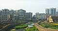
 Countryside near Xingyi | |
 Xingyi is the division at the southwest corner in this map of Qianxinan | |
 Qianxi'nan in Guizhou | |
| Coordinates (Xingyi municipal government): 25°05′31″N 104°53′44″E / 25.0920°N 104.8955°ECoordinates: 25°05′31″N 104°53′44″E / 25.0920°N 104.8955°E | |
| Country | People's Republic of China |
| Province | Guizhou |
| Autonomous prefecture | Qianxi'nan |
| Area | |
| • Total | 2,911 km2 (1,124 sq mi) |
| Population (2010) | |
| • Total | 784,032 |
| • Density | 270/km2 (700/sq mi) |
| Time zone | UTC+8 (China Standard Time) |
| Postal code | 562400 |
| Area code(s) | (0)859 |
| License plate prefixes | 贵E |
| Website | www.gzxy.gov.cn (Chinese) |

Xingyi (simplified Chinese: 兴义; traditional Chinese: 興義; pinyin: Xīngyì) is a county-level city administered by the Qianxinan Buyei and Miao Autonomous Prefecture, in the southwest of Guizhou Province, China.
Geography[]
The city has an area of 2911 square kilometers, and a population of 784,032 as of 2010.[1] It is under the administration of the Qianxinan Buyei and Miao Autonomous Prefecture.

Transportation[]
Xingyi is served by the Nanning–Kunming Railway and by the Xingyi Wanfenglin Airport.
Biodiversity hotspot[]
Based on Red Data Book listed endangered species of fish, amphibians, reptiles, and mammals, Xingyi is one of nine vertebrate biodiversity hotspots of China.[2]
Climate[]
| showClimate data for Xingyi (1981−2010 normals) |
|---|
External links[]
References[]
- ^ "Profile of Xingyi" (in Chinese). XZQH.org. Archived from the original on January 22, 2009. Retrieved 2009-01-28.
- ^ Chen, Yang; An-Ping Chen; Jing-Yun Fang (2002). "Geographical distribution patterns of endangered fishes, amphibians, reptiles and mammals and their hotspots in China: a study based on "China Red Data Book of Endangered Animals"". Biodiversity Science. 10 (4): 359–368.


| Authority control |
|
|---|
Categories:
- Xingyi, Guizhou
- County-level divisions of Guizhou
- Qianxinan Buyei and Miao Autonomous Prefecture