Zhijin County
Zhijin County
织金县 | |
|---|---|
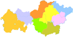 Zhijin is the southernmost division in this map of Bijie | |
 Bijie in Guizhou | |
| Coordinates (Zhijin County government): 26°39′49″N 105°46′13″E / 26.6636°N 105.7702°ECoordinates: 26°39′49″N 105°46′13″E / 26.6636°N 105.7702°E | |
| Country | People's Republic of China |
| Province | Guizhou |
| Prefecture-level city | Bijie |
| Time zone | UTC+8 (China Standard) |

| Zhijin County | |||||||||
|---|---|---|---|---|---|---|---|---|---|
| Traditional Chinese | 織金縣 | ||||||||
| Simplified Chinese | 织金县 | ||||||||
| Literal meaning | Gold-Weaving County | ||||||||
| |||||||||
| Former names | |||||||||
|---|---|---|---|---|---|---|---|---|---|
 "Ping-yuen-fou" and 2 other towns of "Koei-tcheou" from Du Halde's 1736 Description of China, based on reports from Jesuit missionaries | |||||||||
| Pingyuan Prefecture | |||||||||
| Traditional Chinese | 平遠府 | ||||||||
| Simplified Chinese | 平远府 | ||||||||
| Literal meaning | Peaceful-&-Distant Prefecture Pacified-&-Distant Prefecture | ||||||||
| |||||||||
Zhijin County is a county under the administration of the prefecture-level city of Bijie in west-central Guizhou province, China.
History[]
Zhijin has been inhabited since the Qin, populated mainly by the Gelao. After the Jin, the Yi moved in. During the Kangxi Era of the Qing, a city was founded named Pingyuan. In 1914, it was renamed Zhijin after one of its streets.
Geography[]
Zhijin County is located in the southeastern part of Bijie City, roughly in the middle of Guizhou province. It is 151 km from Guiyang, 95 km from Anshun, 129 km from Bijie City. It spans 82.5 km from East to West, and 66 km from North to South. Its total area is 2,868 km2 (1,107 sq mi).
Karst topography dominates the landscape, with caves everywhere. The Zhijin Cave 22 km from the county seat is considered the most magnificent cave in China, and is a popular tourist spot.
The highest point in the county has altitude 2262 m, and the lowest 1319 m.
Climate[]
The average temperature is 14.31 c, with annual rainfall 1356 mm.
| Climate data for Zhijin (1981−2010 normals) | |||||||||||||
|---|---|---|---|---|---|---|---|---|---|---|---|---|---|
| Month | Jan | Feb | Mar | Apr | May | Jun | Jul | Aug | Sep | Oct | Nov | Dec | Year |
| Record high °C (°F) | 21.7 (71.1) |
29.5 (85.1) |
32.2 (90.0) |
32.8 (91.0) |
34.0 (93.2) |
32.6 (90.7) |
32.7 (90.9) |
33.2 (91.8) |
32.4 (90.3) |
29.9 (85.8) |
26.0 (78.8) |
22.0 (71.6) |
34.0 (93.2) |
| Average high °C (°F) | 7.8 (46.0) |
10.3 (50.5) |
15.3 (59.5) |
20.1 (68.2) |
23.2 (73.8) |
24.9 (76.8) |
26.8 (80.2) |
27.0 (80.6) |
24.0 (75.2) |
18.7 (65.7) |
15.0 (59.0) |
10.1 (50.2) |
18.6 (65.5) |
| Daily mean °C (°F) | 4.5 (40.1) |
6.3 (43.3) |
10.4 (50.7) |
15.0 (59.0) |
18.5 (65.3) |
20.8 (69.4) |
22.5 (72.5) |
22.1 (71.8) |
19.2 (66.6) |
15.0 (59.0) |
11.0 (51.8) |
6.4 (43.5) |
14.3 (57.8) |
| Average low °C (°F) | 2.3 (36.1) |
3.8 (38.8) |
7.2 (45.0) |
11.5 (52.7) |
14.9 (58.8) |
17.7 (63.9) |
19.4 (66.9) |
18.7 (65.7) |
16.0 (60.8) |
12.5 (54.5) |
8.3 (46.9) |
3.8 (38.8) |
11.3 (52.4) |
| Record low °C (°F) | −5.1 (22.8) |
−4.2 (24.4) |
−3.7 (25.3) |
1.9 (35.4) |
6.3 (43.3) |
9.9 (49.8) |
10.1 (50.2) |
12.3 (54.1) |
6.7 (44.1) |
1.9 (35.4) |
−2.2 (28.0) |
−5.9 (21.4) |
−5.9 (21.4) |
| Average precipitation mm (inches) | 25.2 (0.99) |
23.8 (0.94) |
31.0 (1.22) |
81.8 (3.22) |
176.1 (6.93) |
272.4 (10.72) |
254.2 (10.01) |
193.2 (7.61) |
132.6 (5.22) |
103.6 (4.08) |
40.3 (1.59) |
21.3 (0.84) |
1,355.5 (53.37) |
| Average relative humidity (%) | 85 | 83 | 79 | 78 | 78 | 82 | 81 | 81 | 80 | 84 | 82 | 82 | 81 |
| Source: China Meteorological Data Service Center | |||||||||||||
Economy[]
The most important industry is tourism, with Zhijin Cave the number one attraction drawing tourists from all over China and the world.
Culture[]
This section is empty. You can help by . (June 2010) |
Demographics[]
There are 23 ethnic groups living in Zhijin, including Han Chinese, Miao, Yi, Hui and Buyei. 48.02% of Zhijin's population are considered minorities in China.
Administration[]
There are 11 towns and 21 townships in the county. Among them are:
External links[]
- Brief information about Zhijin County (in Chinese)
- Local Government website (in Chinese)
- Popular local forum(in Chinese)
This Guizhou location article is a stub. You can help Wikipedia by . |
- County-level divisions of Guizhou
- Bijie
- Guizhou geography stubs