Zeehan
| Zeehan Tasmania | |||||||||
|---|---|---|---|---|---|---|---|---|---|
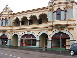 The former Gaiety Theatre at Zeehan, part of the West Coast Pioneers Museum/West Coast Heritage Centre | |||||||||
 Zeehan Location in Tasmania | |||||||||
| Coordinates | 41°53′S 145°20′E / 41.883°S 145.333°ECoordinates: 41°53′S 145°20′E / 41.883°S 145.333°E | ||||||||
| Population | 698 (2016 census)[1] | ||||||||
| • Density | 404.4/km2 (1,047/sq mi) | ||||||||
| Postcode(s) | 7469 | ||||||||
| Elevation | 172 m (564 ft)[2] | ||||||||
| Area | 1.8 km2 (0.7 sq mi) | ||||||||
| Location |
| ||||||||
| LGA(s) | West Coast Council | ||||||||
| State electorate(s) | Braddon | ||||||||
| Federal division(s) | Braddon | ||||||||
| |||||||||

Zeehan /ˈziːən/ is a town on the west coast of Tasmania, Australia 139 kilometres (86 mi) south-west of Burnie. It is located north of Strahan, Tasmania and Queenstown, Tasmania.
In the early 1900s it had its own council.[3] It is currently part of the Municipality of West Coast.
The town was named after the nearby Mount Zeehan which had been named by George Bass and Matthew Flinders after Abel Tasman's fluyt Zeehaen.
History[]
The region has one of the oldest settler histories of any part of Tasmania, when Abel Tasman sighted this part of the state in 1642. An early port for Zeehan was Trial Harbour but it was very precarious in its location on Ocean Beach and was overtaken by Strahan.
Zeehan was established as a mining field, then as a town after the Zeehan-Dundas silver-lead deposits were found in 1882 by Frank Long. Mount Zeehan Post Office opened on 1 August 1888 and was renamed Zeehan in 1890.[4] The peak period for mining was up to the First World War, though lead mining continued on up to 1963 at mines such as the Montana and Oceana. The population of Zeehan-Dundas peaked at 10,000 about 1910, over ten times the current population.
It was clearly in competition with the town further south, Queenstown, and while the silver boom lasted it was known as the Silver City.[5] In the first decade of the twentieth century it was on a par with Launceston and Hobart for size. With a main street over two miles long (3.2 km); it also claimed over 20 hotels. In the 1970s it saw increased activity due to operations at the nearby Renison Bell Tin mine, and again in the 1990s.
At the 2011 census, Zeehan had a population of 728.[1]
Roads[]
Zeehan is connected with the north coast of Tasmania by the Murchison Highway, to Strahan by the Zeehan-Strahan Road, and Queenstown by the Zeehan Highway.
Railways[]
Zeehan was an important railway location—the end of the Emu Bay Railway, and the beginning of the government-owned Strahan-Zeehan Railway service that connected to Strahan and Regatta Point, where the Mount Lyell Railway connected to Queenstown. Also at early stages of the town's history, a series of timber trams spread out from Zeehan towards the Pieman River as well as a number of other locations.
Some of the smaller railway operations east of Zeehan were unique. One had the honour of having the first Garratt steam engine designed and built for its operations.
After the government rail connection between Zeehan and Strahan closed, the Mount Lyell Company trucked its copper ore to the Emu Bay Railway terminus at Melba Flats, a few kilometres east of Zeehan.
Newspapers[]
- See the article: Zeehan and Dundas Herald
Economy[]
Dundas Mining's Avebury nickel mine,[6] Zeehan Zinc's Comstock Mine and Bluestone Tin's Renison Bell tin mine are significant economic contributors to the community, but the majority of the town relies on tourism for its survival.
Tourism features[]
Among these attractions is the West Coast Heritage Centre which was formerly known as the West Coast Pioneers Museum, which is in the old School of Mines building. The main streetscape of Zeehan is one significant feature of the town.
Notable people[]
The famed concert pianist Eileen Joyce was born in Zeehan, and Eileen Joyce Memorial Park in Zeehan was named in her honour.
Notable events[]
Parts of a 1925 Australian silent film, Jewelled Nights were shot[7] on Savage River, north of the town in the Tarkine rainforest.
Bushfires were reported near Zeehan in 1896, 1908, 1977, 1980 and 2006. In November 2012 the town was threatened by bushfires from two directions.[8][9] However, the alert was later removed. There were also bushfires in February 1890 (diary of Edward Jennings and this http://nla.gov.au/nla.news-article13761103).
Climate[]
| Climate data for Zeehan Post Office (1908-1968; precipitation 1890-1968) | |||||||||||||
|---|---|---|---|---|---|---|---|---|---|---|---|---|---|
| Month | Jan | Feb | Mar | Apr | May | Jun | Jul | Aug | Sep | Oct | Nov | Dec | Year |
| Average high °C (°F) | 19.5 (67.1) |
20.2 (68.4) |
18.4 (65.1) |
15.4 (59.7) |
13.2 (55.8) |
11.2 (52.2) |
10.8 (51.4) |
11.5 (52.7) |
13.3 (55.9) |
14.9 (58.8) |
16.3 (61.3) |
18.2 (64.8) |
15.2 (59.4) |
| Average low °C (°F) | 8.8 (47.8) |
9.5 (49.1) |
8.4 (47.1) |
6.9 (44.4) |
5.5 (41.9) |
3.8 (38.8) |
3.4 (38.1) |
3.8 (38.8) |
4.8 (40.6) |
5.7 (42.3) |
6.9 (44.4) |
8.2 (46.8) |
6.3 (43.3) |
| Average precipitation mm (inches) | 137.6 (5.42) |
113.8 (4.48) |
151.0 (5.94) |
215.7 (8.49) |
237.8 (9.36) |
252.2 (9.93) |
264.9 (10.43) |
262.5 (10.33) |
229.7 (9.04) |
221.2 (8.71) |
189.6 (7.46) |
165.3 (6.51) |
2,441.3 (96.1) |
| Source: [10] | |||||||||||||
Gallery[]
| Wikimedia Commons has media related to Zeehan, Tasmania. |
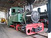
Locomotive,
West Coast Pioneers Museum
Beyer Peacock and Dubbs locomotives,
West Coast Pioneers Museum


See also[]
References[]
- ^ a b Australian Bureau of Statistics (31 October 2012). "Zeehan (SSC) (State Suburb)". 2011 Census QuickStats. Retrieved 13 November 2012.

- ^ a b c d "Climate Data: Zeehan Post Office". Bureau of Meteorology. Retrieved 24 September 2019.
- ^ "Zeehan Council". The North Western Advocate and the Emu Bay Times. Tasmania, Australia. 14 May 1909. p. 4. Retrieved 12 May 2016 – via National Library of Australia.
- ^ Premier Postal History. "Post Office List". Premier Postal Auctions. Retrieved 16 June 2012.
- ^ "MINERAL RETURNS". The Examiner (Tasmania). Vol. LX, no. 79. Tasmania, Australia. 2 April 1900. p. 2 (DAILY.). Retrieved 5 November 2016 – via National Library of Australia.
- ^ "Avebury Nickel Deposit". Retrieved 12 August 2021.
- ^ "Silent movie finds new voice". ABC News. Retrieved 30 January 2016.
- ^ "Two bushfires threaten Tasmanian town". ABC News. Retrieved 30 January 2016.
- ^ "TFS Map". Tasmania Fire Service. Retrieved 30 January 2016.
- ^ Bureau of Meteorology "Climate statistics for Zeehan Post Office", [1]
Further reading[]
- Blainey, Geoffrey (2000). The Peaks of Lyell (6th ed.). Hobart: St. David's Park Publishing. ISBN 0-7246-2265-9.
- Manny, L.B. (1963) Railways of the Zeehan District Australian Railway Historical Society Bulletin, October/November.
- Rae, Lou (2001). The Abt Railway and Railways of the Lyell region. Sandy Bay: Lou Rae. ISBN 0-9592098-7-5.
- Whitham, Charles (2003). Western Tasmania - A land of riches and beauty (Reprint 2003 ed.). Queenstown: Municipality of Queenstown.
- Whitham, Lindsay (2002). Railways, Mines, Pubs and People and other historical research. Sandy Bay: Tasmanian Historical Research Association. ISBN 0-909479-21-6.
- Towns in Tasmania
- Zeehan
- Localities of West Coast Council
- Mining towns in Tasmania
- 1888 establishments in Australia