Zhoushan
Zhoushan
舟山市 Chou Shan | |
|---|---|
 Skyline of the new city center | |
 | |
 Location in Zhejiang | |
| Coordinates (Zhoushan municipal government): 29°59′08″N 122°12′27″E / 29.9856°N 122.2074°ECoordinates: 29°59′08″N 122°12′27″E / 29.9856°N 122.2074°E | |
| Country | People's Republic of China |
| Province | Zhejiang |
| County divisions | 4 |
| Township divisions | 45 |
| County established | Tang Dynasty |
| Converted to prefecture-level city | 1987 |
| Municipal seat | Dinghai District |
| Government | |
| • CPC Secretary | Yu Donglai (俞东来) |
| • Mayor | Wen Nuan (温暖) |
| Area | |
| • Total | 22,200 km2 (8,600 sq mi) |
| • Land | 1,440.12 km2 (556.03 sq mi) |
| • Water | 20,800 km2 (8,000 sq mi) |
| Population (2015 census[1]) | |
| • Total | 1,152,000 |
| Time zone | UTC+8 (China Standard) |
| Postal code | 316000, 202450 for Shengsi County |
| Area code(s) | (0)580 |
| ISO 3166 code | CN-ZJ-09 |
| GDP | $9.518 billion |
| GDP per capita | $15,514.38 |
| License Plate | 浙L |
| Website | www |

| Zhoushan | |||
|---|---|---|---|
 "Zhoushan" in Chinese | |||
| Chinese | 舟山 | ||
| Wu | Cieu平-se平 (Ningbonese) Tseu平-sae平 (Shanghainese) | ||
| Postal | Chusan | ||
| Literal meaning | Barge Island[a][2] | ||
| |||
| Former names | |||
|---|---|---|---|
| Yongdong | |||
| Traditional Chinese | 甬東 | ||
| Simplified Chinese | 甬东 | ||
| Literal meaning | [Land] East of Yong [Land] East of the Yong | ||
| |||
| Wengshan | |||
| Chinese | 翁山 | ||
| Literal meaning | Senior Island | ||
| |||
| Changguo | |||
| Traditional Chinese | 昌國 | ||
| Simplified Chinese | 昌国 | ||
| Literal meaning | Prosperous Country | ||
| |||
| Dinghai | |||
| Chinese | 定海 | ||
| Literal meaning | Stabilizing the Sea | ||
| |||
Zhoushan ![]() listen (help·info), formerly romanized as Chusan, is an urbanized archipelago with the administrative status of a prefecture-level city in the eastern Chinese province of Zhejiang.[b] It consists of an archipelago of islands at the southern mouth of Hangzhou Bay, off Ningbo. The prefecture's city proper is Dinghai on Zhoushan Island, now administered as the prefecture's Dinghai District. During the 2010 census, Zhoushan Prefecture's population was 1,121,261, out of whom 842,989 lived in the urban districts of Dinghai and Putuo.
listen (help·info), formerly romanized as Chusan, is an urbanized archipelago with the administrative status of a prefecture-level city in the eastern Chinese province of Zhejiang.[b] It consists of an archipelago of islands at the southern mouth of Hangzhou Bay, off Ningbo. The prefecture's city proper is Dinghai on Zhoushan Island, now administered as the prefecture's Dinghai District. During the 2010 census, Zhoushan Prefecture's population was 1,121,261, out of whom 842,989 lived in the urban districts of Dinghai and Putuo.
On 8 July 2011 the central government approved Zhoushan as Zhoushan Archipelago New Area, a state-level new area.
History[]


The archipelago was inhabited 6,000 years ago during the Neolithic by people of the Hemudu culture. During the Spring and Autumn period, Zhoushan was called Yongdong, referring to its location east of the Yong River. At the time, it belonged to the state of Yue. The fishermen and sailors who inhabited the islands often engaged in piracy and became recruits for uprisings against the central authorities. At the time of the Eastern Jin, the Zhoushan Islands served as the base for Sun En's rebellion. Sun En, an adherent of the Taoist sect the Way of the Five Pecks of Rice, launched his rebellion around the year 400 and was defeated by Jin forces in 402.[3] Today's Zhoushan was first created as Wengshan County in Ming Prefecture in 738 under the Tang.
In 863, the Japanese Buddhist monk Egaku (慧锷)[4] and a Putuoshan local Zhang-shi (张氏) placed a statue of Guanyin at Chaoyin Cave (潮音洞) that would later become a popular tourist and pilgrim destination. In 1073, under the Song, it was renamed Changguo County; this was upgraded to a prefecture in the early Yuan dynasty.During the Ming dynasty, especially between the years 1530 and 1560, Japanese and Chinese pirates used Zhoushan as one of their principal bases from which they launched attacks as far as Nanjing; "the whole Chinese coast from northern Shandong to western Guangdong was ravaged to a distance of sixty miles inland."[5]
After suppression of the pirates, Zhoushan became an important commercial port of entry. Under the early Qing dynasty, it played a similar role to Xiamen and Guangzhou as a frequent port of call for Western traders.[6] Changguo Prefecture became Dinghai County within Zhejiang Province in 1688 under the Qing. The restriction of all European trade to the port of Guangzhou in 1760 forced Westerners to leave Zhoushan. One of the requests of Lord Macartney's embassy to the Qianlong Emperor in 1793 was an acquisition of "a small unfortified island near Zhoushan for the residence of English traders, storage of goods, and outfitting of ships." The Qianlong Emperor denied this request together with all the rest.[7]
British forces under Captain Charles Elliot captured Zhoushan on 5–6 July 1840 during the First Opium War and evacuated it in early 1841, after Elliot reached an agreement with Qishan, the Governor-General of Tianjin and Grand Secretary to the Daoguang Emperor, in exchange for cession of Hong Kong.[8] At that time, Zhoushan was a well known port while Hong Kong was still only a fishing village.[citation needed] The British Foreign Secretary Palmerston was furious when he learned that Elliot agreed to the cession of Hong Kong ("a barren island with hardly a house on it")[citation needed] while giving up Zhoushan. Elliot was dismissed in April 1841 for his blunder.[9] His replacement Sir Henry Pottinger led a British fleet that recaptured Zhoushan on 1 October 1841.[10] The First Opium War ended with conclusion of the Treaty of Nanjing in which China opened up the cities of Guangzhou ("Canton"), Fuzhou ("Foochow"), Xiamen ("Amoy"), Ningbo ("Ningpo"), and Shanghai to residence by British subjects for the purpose of trade. As a result, Britain no longer had any use for Zhoushan but it kept the island until 1846 as a guarantee for the fulfilment of the stipulations of the treaty.[11] Dinghai was upgraded to a directly controlled subprefecture (定海直隸廳) sometime in 1841.
Zhoushan was also occupied by the British in 1860 during the Second Opium War.[citation needed] Wang Yijun, a leader of the Taiping rebels, attempted to retake Zhoushan from its Qing garrison on 13 February 1862 but was defeated and killed.
Following the Xinhai Revolution and the establishment of the Republic of China, Dinghai Subprefecture reverted to a county. Sun Yat-sen visited Zhoushan on 25 August 1916 and wrote Travelling to Putuo (游普陀志奇, You Putuo Zhiqi). On 1 October 1942, the Japanese ship Lisbon Maru was transporting 1,800 POWs to Tokyo when she was attacked by the USS Grouper off (青浜) or ; one torpedo hit and she sank the next day. The fishermen of nearby Dongji (东极乡) rescued 384 of the British prisoners from the wreckage. Amid the Chinese Civil War, Dinghai County lost Shengsi, which became an Archipelago Directly controlled District (列島直屬區) of Jiangsu in 1946, then a separate county in October 1949. The same year, Dinghai County was divided into Dinghai and (翁洲) Counties. In November, the Communists landed on Dengbu Island, but were repulsed by the defenders.
Nevertheless, Zhoushan was overrun by the Communists on 17 May 1950. Wengzhou was merged back into Dinghai County, which made up part of Ningbo Prefecture, and Shengsi made up a special area (特区) and then county of the Songjiang Prefecture, then still part of Jiangsu. In March 1953, the Council of Ministers opted to establish the Zhoushan Prefecture, returning Shengsi and dividing Dinghai into Dinghai, Putuo, and Daishan. Ningbo's Xiangshan County was also briefly incorporated into this new prefecture from 1954 to 1958. From 1958 to May 1962, Zhoushan was incorporated into Ningbo before becoming a separate prefecture again. Shengsi was temporarily assigned to Shanghai in the early 1960s. The short-lived Daqu County (大衢縣) was created in 1962 before being redivided between Daishan and Shengsi four years later.
Zhoushan was promoted to a prefecture-level "city" on 27 January 1987, with Dinghai and Putuo Counties upgraded to districts. The municipal People's Government was established on 8 March of that year. April of the same year, the ports of Zhoushan became open to foreign ships. On 10 April 1988, it became a coastal economic open zone.
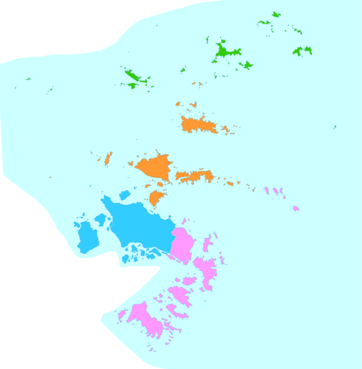
Administrative divisions[]
Zhoushan administers two districts and two counties. The city currently consists of 36 township-level divisions, including 17 towns, 5 townships and 14 subdistricts. Detailed divisions are listed as follows.
| Map | ||||
|---|---|---|---|---|
| Subdivision | Hanzi | Pinyin | Population (2010) | Terrestrial Area (km2) |
| Dinghai District | 定海区 | Dìnghǎi Qū | 464,184 | 568.8 |
| Putuo District | 普陀区 | Pǔtuó Qū | 378,805 | 458.6 |
| Daishan County | 岱山县 | Dàishān Xiàn | 202,164 | 326.5 |
| Shengsi County | 嵊泗县 | Shèngsì Xiàn | 76,108 | 86 |
- Dinghai District (13 divisions, including 10 sub-districts and 3 towns)
- Sub-district: Jiefang (解放), Changguo (昌国), Huannan (環南), Chengdong (城東), Yancang (盐倉), Lincheng (临城), Qiandao (千島), Xiaosha (小沙), Ma'ao (馬岙), Cengang (岑港)
- Town: Baiquan (白泉), Jintang (金塘), Ganlan (干