10th arrondissement of Paris
10th arrondissement of Paris | |
|---|---|
 The town hall, | |
 Location within Paris | |
| Coordinates: 48°52′32″N 2°21′28″E / 48.87556°N 2.35778°ECoordinates: 48°52′32″N 2°21′28″E / 48.87556°N 2.35778°E | |
| Country | France |
| Region | Île-de-France |
| Department | Paris |
| Commune | Paris |
| Government | |
| • Mayor (2020–2026) | (PS) |
| Area | 2.89 km2 (1.12 sq mi) |
| Population (Jan. 2018)[1] | 88,557 |
| • Density | 30,643/km2 (79,370/sq mi) |
| INSEE code | 75110 |
 20 arrondissements of Paris | |||||||||||||||||||||||||||||||||||||
|---|---|---|---|---|---|---|---|---|---|---|---|---|---|---|---|---|---|---|---|---|---|---|---|---|---|---|---|---|---|---|---|---|---|---|---|---|---|
| |||||||||||||||||||||||||||||||||||||
The 10th arrondissement of Paris (Xe arrondissement) is one of the 20 arrondissements of the capital city of France. In spoken French, this arrondissement is referred to as dixième ("10th arrondissement of Paris" = "dixième arrondissement de Paris").
The arrondissement, called Entrepôt (warehouse), is situated on the right bank of the River Seine. The arrondissement contains two of Paris's six main railway stations: the Gare du Nord and the Gare de l'Est. Built during the 19th century, these two termini are among the busiest in Europe.
The 10th arrondissement also contains a large portion of the Canal Saint-Martin, linking the northeastern parts of Paris with the River Seine.
Geography[]
The land area of the arrondissement is 2.892 km2 (1.117 sq. miles, or 715 acres), and it had a 1999 population of 89,695.
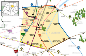
The 10th arrondissement is often referred to as l'Entrepôt. Like all Parisian arrondissements, it is divided into four quartiers (districts):[2]
- Saint-Vincent-de-Paul, the 37th quartier, has 21,624 people in an area of 92.7 hectares
- Porte-Saint-Denis, the 38th quartier, has 15,066 people in an area of 47.2 hectares
- Porte-Saint-Martin, the 39th quartier, has 23,125 people in an area of 60.9 hectares
- Hôpital-Saint-Louis, the 40th quartier, has 29,870 people in an area of 88.4 hectares
Demography[]
The peak population of the 10th arrondissement occurred in 1881, when it had 159,809 inhabitants. Today, the arrondissement remains very dense in both population and business activity, with 89,612 inhabitants and 71,962 jobs at last census in 1999. Due to its large Turkish minority, the 10th arrondissement is often called "La Petite Turquie" (Little Turkey).[3]
Historical population[]
| Year (of French censuses) |
Population | Density (inh. per km2) |
|---|---|---|
| 1872 | 135,392 | 46,848 |
| 1881 (peak of population) | 159,809 | 55,259 |
| 1954 | 129,179 | 44,699 |
| 1962 | 124,497 | 43,049 |
| 1968 | 113,372 | 39,202 |
| 1975 | 94,046 | 32,519 |
| 1982 | 86,970 | 30,073 |
| 1990 | 90,083 | 31,149 |
| 1999 | 89,612 | 30,986 |
| 2009 | 95,911 | 33,187 |
Immigration[]
| Born in metropolitan France | Born outside metropolitan France | |||
|---|---|---|---|---|
| 70.4% | 29.6% | |||
| Born in overseas France |
Born in foreign countries with French citizenship at birth1 | EU-15 immigrants2 | Non-EU-15 immigrants | |
| 1.3% | 4.1% | 4.4% | 19.8% | |
| 1 This group is made up largely of former French settlers, such as Pieds-Noirs in Northwest Africa, followed by former colonial citizens who had French citizenship at birth (such as was often the case for the native elite in French colonies), as well as to a lesser extent foreign-born children of French expatriates. Note that a foreign country is understood as a country not part of France in 1999, so a person born for example in 1950 in Algeria, when Algeria was an integral part of France, is nonetheless listed as a person born in a foreign country in French statistics. 2 An immigrant is a person born in a foreign country not having French citizenship at birth. Note that an immigrant may have acquired French citizenship since moving to France, but is still considered an immigrant in French statistics. On the other hand, persons born in France with foreign citizenship (the children of immigrants) are not listed as immigrants. | ||||
Map[]

Cityscape[]
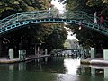
The canal Saint-Martin.

Saint-Vincent-de-Paul.

Place de la République
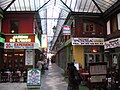
Passage Brady

Gare du Nord


Places of interest[]
- Canal Saint-Martin
- Gare de l'Est
- Gare du Nord
- Musée de l'Éventail (museum of fans)
- Passage Brady
- Porte Saint-Denis
- Porte Saint-Martin
- Church of Saint-Vincent-de-Paul
- Church of Saint-Laurent
Mains streets and squares[]
Streets[]
|
|
|
|
|
Squares[]
|
|
References[]
- ^ "Populations légales 2018". INSEE. 28 December 2020.
- ^ All demographic figures are from the Mairie de Paris, 1999.
- ^ Le Petit Journal. ""LA PETITE TURQUIE" - Balade dans le quartier turc de Paris". Archived from the original on 2014-05-30. Retrieved 2014-12-14.
External links[]
| Wikimedia Commons has media related to Paris 10e arrondissement. |
 10th arrondissement travel guide from Wikivoyage
 | ||
- 10th arrondissement of Paris