1839 Ava earthquake
 | |
 1839 Ava earthquake (Myanmar) | |
| UTC time | 1839-03-23 24:30 |
|---|---|
| Local date | 23 March 1839 |
| Local time | 04:00 |
| Magnitude | 7.4–8.3 Mw 8.0 Mw[1] |
| Epicenter | 21°54′N 96°00′E / 21.9°N 96.0°ECoordinates: 21°54′N 96°00′E / 21.9°N 96.0°E |
| Fault | Sagaing Fault |
| Type | Strike-slip |
| Areas affected | Konbaung dynasty (present–day Myanmar) |
| Total damage | 3 cities destroyed |
| Max. intensity | XI (Extreme) |
| Foreshocks | Yes |
| Aftershocks | Yes |
| Casualties | 500+ dead |

The 1839 Ava earthquake, also known as the Amarapura earthquake or Inwa earthquake was a disastrous seismic event that struck central Burma on the morning of March 23.[2] This earthquake with a moment magnitude as high as 8.3, was one of the biggest in the country since 1762. Shaking reached XI (Extreme) on the Mercalli intensity scale, and was felt in Rangoon and Bhamo.[3]
Earthquake[]
The Sagaing Fault is a major transform boundary that runs through Myanmar, and is the source of the earthquake. The earthquake epicenter is presently located just outside the city of Mandalay. It is believed that the Meiktila and Sagaing segment of the fault ruptured during this earthquake for a length of 400 km, generating an earthquake of magnitude 8.1 to 8.3 although further research is needed to confirm this.[4] The basis for this claim is the overall lack of seismic activity in the Meiktila segment which runs from Nay Pyi Taw to Mandalay, a length of about 260 km. There is no official magnitude presented for this earthquake but most news media and research journals put the figure at 7.0–7.5 or ≥8.0 Mw .[5][6] Remote sensing and field observation revealed a maximum displacement of 5 to 7 meters along the trace of the 1839 rupture just outside Mandalay. This would place the magnitude at 7.4 or 8.0+, and generate an earthquake rupture of at least 300 km.[7][8]
In 1946 the 180 km long Sagaing segment produced two major earthquakes but there are no records of its impact. Ten years later, in 1956, a magnitude 7.1 earthquake struck close to the city of Mandalay, re–rupturing the 1839 rupture zone for about 60 km.[9] Meanwhile the 260 km long Meiktila segment has not experienced any major earthquake since 1839 and is considered a seismic gap.[4]
Foreshocks[]
It was preceded by a large foreshock in 1838 which also damaged the capital.[10]
Damage and effects[]
Great damage was reported in Inwa, so severe that the formal capital was moved to nearby Amarapura. In Mingun, a stupa sustained serious damage as a result of shaking. British officials in Myanmar recorded catastrophic damage and liquefaction in Mandalay and the surrounding area.[11][12] Many pagodas collapsed during the event. Chasms and fissures more than ten feet wide were seen in Amarapura and nearly every brick buildings were reduced to rubble. Some villages were swallowed up as a result of liquefaction.[12] Between 200 and 300 people were killed. The shock also reversed the flow of the Irrawaddy River, where the currents became violent and overflowed its banks.[11]
Gallery[]
- Inwa

Large cracks in the incomplete Mingun Pahtodawgyi caused by the earthquake.

Nan Myint Tower slightly tilted due to ground effects from the tremor.
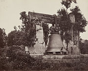
The Mingun Bell resting on the ground after losing its supports to the quake, pictured in 1873.
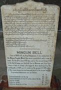
A plague that stands beside the Mingun Bell.

The Hsinbyume Pagoda in 2014. Extensive restoration was dome by Mindon Min in 1874 after the earthquake.

The Maha Aungmye Bonzan Monastery after repair works.

Preserved ruins from the ancient capital.
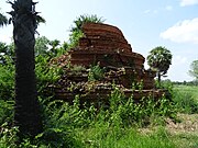
Overgrown ruins of a stupa.


See also[]
References[]
- ^ "Global Historical Earthquake Archive". emidius.eu. Global Historical Earthquake Archive. Retrieved 22 October 2021.
- ^ Oldham, Thomas. "A Catalogue of Indian Earthquakes from the earliest time to the end of AD 1869". Memoirs of the Geological Survey of India. XIX.
- ^ "Earthquake Event Information MYANMAR (BURMA): AVA, AMARAPURA". NGDC.
- ^ a b Yu, Wang (2014). "Active Tectonics and Earthquake Potential of the Myanmar region". Journal of Geophysical Research: Solid Earth. 119 (4): 3767. Bibcode:2014JGRB..119.3767W. doi:10.1002/2013JB010762.
- ^ Tapponnier, Paul; Kerry, Kerry (21 January 2010). "The Catastrophe in Haiti: A Repeat Lesson for Us all" (PDF). RSIS Commentaries. Nanyang Technological University. Retrieved 23 March 2021.
- ^ Thant, Htoo (7 August 2019). "Govt unveils quake preparedness plan". Myanmar Times. Myanmar Times. Retrieved 23 March 2021.
- ^ "Morphotectonics of the Central Sagaing fault West of Mandalay: Trace of the 1839 Ava Earthquake Rupture". AGU. Retrieved 23 March 2021.
- ^ Xinhua (25 November 2009). "Myanmar setting up global positioning system for earthquake monitoring". People's Daily Online. People's Daily Online. Retrieved 23 March 2021.
- ^ Soe Thura Tun; Ian M. Watkinson (15 November 2017). "The Sagaing Fault, Myanmar". Geological Society, London, Memoirs. 48: 413–441. doi:10.1144/M48.19. S2CID 134291037. Retrieved 23 March 2021.
- ^ "Significant Earthquake Information MYANMAR (BURMA): AVA (INNWA)". NGDC NCEI. NGDC NCEI. Retrieved 23 March 2021.
- ^ a b "Some Documents of Tharrawaddy's Reign: 1837-1846, Part I". SOAS Bulletin of Burma Research. 1. 2003.
- ^ a b "Burmah". The Asiatic Journal. XXX. 1839.
This article about an earthquake in Asia is a stub. You can help Wikipedia by . |
- Earthquakes in Myanmar
- 1839 in Asia
- History of Myanmar
- Earthquakes in Asia
- 19th century in Burma
- British rule in Burma
- 1830s earthquakes
- 1839 natural disasters
- 1839 disasters
- Strike-slip earthquakes
- Asian earthquake stubs