1993 Kushiro earthquake
  | |
| UTC time | 1993-01-15 11:06:05 |
|---|---|
| ISC event | 252904 |
| USGS-ANSS | ComCat |
| Local date | 15 January 1993 |
| Magnitude | 7.6 Mw 7.8 MJMA |
| Depth | 102.2 km |
| Epicenter | 43°18′00″N 143°41′28″E / 43.300°N 143.691°ECoordinates: 43°18′00″N 143°41′28″E / 43.300°N 143.691°E |
| Type | Intraplate |
| Total damage | ¥94.1 billion |
| Max. intensity | VIII (Severe) JMA 6+ |
| Peak acceleration | 0.94 g |
| Peak velocity | 922 cm/s |
| Tsunami | None |
| Landslides | Yes |
| Aftershocks | Yes |
| Casualties | 2 dead 966 injured[1] |

The 1993 Kushiro–Oki earthquake (釧路沖地震, Kushiro-Oki Jishin) was one of two large earthquake to strike the Japanese island of Hōkkaido within the same year. The earthquake with a magnitude of 7.6 Mw or 7.8 MJMA struck at 11:06 UTC or 08:06 pm JST on January 15 near the town of Ashoro. Shaking reached a maximum intensity of VIII (Severe) on the Mercalli intensity scale, causing considerable damage, and was felt throughout the island, into northern Honshu, Sakhalin, and the Kuril Islands. As a result of the tremors, two people were killed and more than 600 were wounded.[2]
This earthquake was followed up by another 7.7 Mw earthquake six months later, occurring in the Sea of Japan which triggered a deadly tsunami. Over 200 deaths were recorded, with many missing. Although that earthquake killed more people, it was felt over a smaller area compared to the event in January, possibly because it had a deeper depth of focus.
Tectonic setting[]
Hokkaidō sits near a convergent plate boundary where the Pacific Plate is subducting beneath the Okhotsk Plate at a rate of 8.5–9.0 cm/yr along the Kuril and Japan trenches.[3] The associated plate boundary megathrust would rupture in moderate to very large megathrust earthquakes such as those seen in 1952, 1963, 2003 and 2011. However, earthquakes also occur within the downgoing Pacific slab along faults that release strain within it. These intraplate earthquakes can have a focal depth of up to 100 km or deeper under the island.
Earthquake[]
The magnitude 7.6 Kushiro–Oki earthquake was an intraplate event occurring at a depth of 102 km beneath Hokkaidō along a 60 km by 40 km, near horizontal fault within the underthrusted slab.[4] The fault ruptured at a velocity of 3.6 km/s, producing an average slip of 5.5 meters, with the maximum slip at 11 meters.[5]
Effects[]
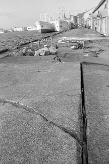
Strong ground acceleration of up to 922 cm/s² was recorded at Kushiro, lasting 30 seconds which caused extensive liquefaction and damage to the city.[6] In the city, 6 homes collapsed while 590 were affected, 33 of them sustaining serious damage. Further destruction of properties resulted from landslides and slope failures, some posing additional threats even after the earthquake. During one of the many landslides, a house slid ten meters down the slopes of a hill. The port area was also destroyed by liquefaction, revealing buried manholes and sewage pipes which emerged 1.5 meters above the surface.[7][8] Farm roads, irrigation and drainage canals, and pipelines were severely damaged by ground failures induced by the shaking.[9] More roads across 18 locations had to be closed due to the failure of embankments. Slope failures were common around Kushiro, which brought down with it local homes.[10]
Gas pipelines were damaged, affecting more than 9,300 residents when supply ceased. It was only restored 23 days later. Water was also inaccessible to 4,000 people for five days. Throughout the island, over 57,000 were left without power after the quake but was quickly restored by the next day.
Since the earthquake occurred during the winter time, thorough inspection of dams could not be conducted as snow fall had completely covered the structures. It was only in the spring did engineers began their investigation. The Mombetsu Dam was found with some damage; the concrete slope protection on the upstream side of that dam had been raised slightly, but they weren't found to affect the state of the dam. Deformation on the ground slope of the left bank was also discovered when the reservoir was drained.[11]
Retrofitting works done would spare the city from damage once again when the Kuril Islands was struck with a much bigger earthquake in October 1994.
Casualties[]
Two people were killed, one died from a ceiling light falling on them, the other was poisoned by gas. Sixty-one survivors were badly injured while another 661 had minor injuries to them.[12]
See also[]
References[]
- ^ "The Kushiro-Oki Earthquake, 1993 (January 15, M7.8) (Japan Meteorological Agency)" (PDF). Sapporo District Meteorological Observatory, JMA. Cite journal requires
|journal=(help) - ^ "Significant Earthquake Information JAPAN: HOKKADIO, KUSHIRO, HACHINOHE, HONSHU". NGDC. Retrieved 9 January 2021.
- ^ Okuda, Takashi; Ide, Satoshi (2018). "Streak and hierarchical structures of the Tohoku–Hokkaido subduction zone plate boundary". Earth, Planets and Space. 70 (132). doi:10.1186/s40623-018-0903-8 – via Springer.
- ^ Suzuki, Sadaomi; Kasahara, Minoru (1996). "Unbending and horizontal fracture of the subducting Pacific plate, as evidenced by the 1993 Kushiro-oki and the 1981 and 1987 intermediate-depth earthquakes in Hokkaido". Physics of the Earth and Planetary Interiors. 93 (1–2): 91–104. doi:10.1016/0031-9201(95)03090-5. ISSN 0031-9201.
- ^ T. Sasatani, N. Morikawa (2002). "ASPERITY SOURCE MODEL OF THE 1993 KUSHIRO-OKI EARTHQUAKE (Mw7.6): A LARGE INTRA-SLAB EARTHQUAKE" (PDF). 13th World Conference on Earthquake Engineering.
- ^ Sasatani, T. (1996). "Side effects in Kushiro during the 1993 Kushiro-oki earthquake and the 1994 Hokkaido Toho-oki earthquakes". Eleventh World Conference on Earthquake Engineering. Hokkaido University (2029).
- ^ Fumio Yamazaki, Kimiro Meguro, Huanan Tong (1995). "General review of recent five damaging earthquakes in Japan" (PDF). Bull. ERS (28).CS1 maint: multiple names: authors list (link)
- ^ Kohji Tokimatsu, Toru Sekiguchi and Akio Abe (2000). "EFFECTS OF HIDDEN VALLEY ON GROUND RESPONSE AND DAMAGE DISTRIBUTION IN THE 1993 KUSHIRO-OKI EARTHQUAKE" (PDF). 12th World Conf. on Earthquake Engrg.
- ^ "Damage to Agricultural Facilities Caused by the 1993 Kushiro-oki and Hokkaido Nansei-Oki Earthquakes". Missouri University of Science and Technology. 1995. Retrieved 9 January 2021.
- ^ Meguro, Kimiro; Kumazawa, Fumitoshi; Mikami, Atsushi (1995). "Damage report on the 1994 Hokkaido-Toho-Oki Earthquake" (PDF). Bull. ERS. 28: 77–95.
- ^ Akira Nakamura, Shota Yasuda, Tomoya Iwashita (1994). "Behavior of dams during the 1993 Kushiro-oki Earthquake and the 1993 Hokkaido Nansei-oki Earthquake". Japan Society of Dam Engineers. 4 (6): 31–44.CS1 maint: multiple names: authors list (link)
- ^ "Report of the January 15, 1993 Kushiro-oki Earthquake" (PDF). EERI Newsletter. 27 (8). 1993.
- 1993 earthquakes
- 1993 in Japan
- January 1993 events in Asia
- Earthquakes of the Heisei period