1999 İzmit earthquake
 | |
| UTC time | 1999-08-17 00:01:38 |
|---|---|
| ISC event | 1655218 |
| USGS-ANSS | ComCat |
| Local date | 17 August 1999 |
| Local time | 03:01 |
| Duration | 37 seconds[1] |
| Magnitude | 7.6 Mw[2][3] 7.4 ML[4] |
| Depth | 15.0 km (9.3 mi)[2] |
| Epicenter | 40°44′53″N 29°51′50″E / 40.748°N 29.864°ECoordinates: 40°44′53″N 29°51′50″E / 40.748°N 29.864°E |
| Fault | North Anatolian Fault |
| Type | Strike-slip[1] |
| Areas affected | Turkey |
| Total damage | 3–8.5 billion USD[3] |
| Max. intensity | IX (Violent)[5] |
| Peak acceleration | .3–.4g[1] |
| Tsunami | 2.52 m (8.3 ft)[3] |
| Casualties | 17,118–17,127 dead[3] 43,953–50,000 injured[3] |


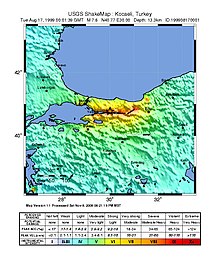
On 17 August 1999, an earthquake in northwestern Turkey killed around 17,000 people[6] and left more than 250,000 people homeless. The shock had a moment magnitude of 7.6 and a maximum Mercalli intensity of IX (Violent). The event lasted for 37 seconds, severely damaging the city of İzmit.
Earthquake[]
The earthquake occurred along the western portion of the North Anatolian Fault Zone (NAFZ). The Anatolian Plate, which consists primarily of Turkey, is being pushed west about 2–2.5 cm (0.8–1.0 in) a year, as it is squeezed between the Eurasian Plate to the north and the Arabian Plate to the south.[7] Major earthquakes in Turkey result mainly from slip along the NAFZ or the East Anatolian Fault.
The Izmit earthquake had a rupture length of 150 kilometers (93 mi) extending from the city of Düzce all the way into the Sea of Marmara along the Gulf of İzmit. Offsets along the rupture were as large as 5.7 meters (18.7 ft).[8]
From the timing of P-wave and S-wave arrivals at seismometers there is strong evidence that the rupture propagated eastwards from the epicentre at speeds in excess of the S-wave velocity, making this a supershear earthquake.[9]
Damage[]
Destruction in Istanbul was concentrated in the Avcılar district to the west of the city. Avcılar was built on relatively weak ground mainly composed of poorly consolidated Cenozoic sedimentary rocks, which makes this district vulnerable to any earthquake.[10]

The earthquake was heavily felt in this industrialized and densely populated urban area of the country, including oil refineries, several automotive plants, and the Turkish navy headquarters and arsenal in Gölcük, increasing the severity of the loss of life and property. The earthquake also caused considerable damage in Istanbul, about 70 kilometres (43 mi) away from the earthquake's epicenter.[1]
An official Turkish estimate of 19 October 1999 placed the toll at 17,127 killed and 43,959 injured, but many sources suggest the actual figure may have been closer to 45,000 dead and a similar number injured.[6] Reports from September 1999 show that 120,000 poorly engineered houses were damaged beyond repair[citation needed] and approximately 20,000 buildings collapsed, resulting in more than 250,000 people becoming homeless after the earthquake.[11]
There was extensive damage to several bridges and other structures on the Trans-European Motorway (European route E80), including 20 viaducts, 5 tunnels, and some overpasses. Damage ranged from spalling concrete to total deck collapse.[12]
Fire[]
The earthquake sparked a disastrous fire at the Tüpraş petroleum refinery. The fire began at a state-owned tank farm and was initiated by naphtha that had spilled from a holding tank. Breakage in water pipelines, results of the quake, nullified attempts at extinguishing the fire. Aircraft were called in to douse the flames with foam. The fire spread over the next few days, warranting the evacuation of the area within three miles of the refinery. The fire was declared under control five days later after claiming at least seventeen tanks and untold amounts of complex piping.[13]
Tsunami[]
The earthquake caused a tsunami in the Sea of Marmara that was about 2.5 meters high. The tsunami caused the deaths of 155 people.[14]
Response[]
A massive international response was mounted to assist in digging for survivors and assisting the wounded and homeless. Rescue teams were dispatched within 24–48 hours of the disaster, and the assistance to the survivors was channeled through NGOs and the Red Crescent and local search and rescue organizations.
The following table shows the breakdown of rescue teams by country in the affected locations:
| Location | Foreign Search and Rescue Teams From: |
|---|---|
| Gölcük, Kocaeli | Hungary, Israel, France, South Korea, Belgium, Russia |
| Yalova | Germany, Hungary, Israel, Poland,[15] United Kingdom, France, Japan, Austria, Romania, South Korea |
| Avcılar, Istanbul | Greece, Germany |
| İzmit, Kocaeli | Russia, Hungary, France, Germany, Austria, Switzerland, United States, Iceland, South Korea |
| Sakarya | Bulgaria, Egypt, Germany, Spain |
| Düzce | Poland,[15] United Kingdom |
| Bayrampaşa, Istanbul | Italy |
| Kartal, Istanbul | Azerbaijan |
Search and Rescue Effort as of 19 August 1999. Source: USAID[16]
In total, rescue teams from twelve countries assisted in the rescue effort.
Oil Spill Response Limited were activated by BP to deploy from the United Kingdom to the Tüpraş Refinery where their responders successfully contained the previously uncontrolled discharge of oil from the site into the sea.[17]
The U.K announced an immediate grant of £50,000 to help the Turkish Red Crescent, while the International Red Cross and Red Crescent pledged £4.5 million to help victims. Blankets, medical supplies and food were flown from Stansted airport. Engineers from Thames Water went to help restore water supplies.[citation needed] India also assisted by providing 32,000 tents and 2 million rupees to help in the reconstruction process.[citation needed]
US President Bill Clinton[18] and Pakistani Prime Minister Nawaz Sharif later visited Istanbul and İzmit to examine the level of destruction and meet with the survivors.[citation needed]
See also[]
- 1999 Düzce earthquake
- List of earthquakes in 1999
- List of earthquakes in Turkey
- Yalova Earthquake Monument
References[]
- ^ Jump up to: a b c d Barka, A. (1999), "The 17 August 1999 Izmit Earthquake", Science, 285 (5435): 1858–1859, doi:10.1126/science.285.5435.1858, S2CID 129752499
- ^ Jump up to: a b ISC (2014), ISC-GEM Global Instrumental Earthquake Catalogue (1900–2009), Version 1.05, International Seismological Centre
- ^ Jump up to: a b c d e USGS (September 4, 2009), PAGER-CAT Earthquake Catalog, Version 2008_06.1, United States Geological Survey
- ^ "The Izmit, Turkey Earthquake of August 17, 1999" (PDF).
- ^ USGS (December 1, 2008), EXPO-CAT Earthquake Catalog, Version 2007-12, United States Geological Survey
- ^ Jump up to: a b Marza, Vasile I. (2004). "On the death toll of the 1999 Izmit (Turkey) major earthquake" (PDF). ESC General Assembly Papers, Potsdam: European Seismological Commission. Archived from the original (PDF) on 9 April 2008. Retrieved 5 March 2008. Cite journal requires
|journal=(help) - ^ USGS (June 18, 2012). "Tectonic summary". Historic Earthquakes Magnitude 7.6 TURKEY 1999 August 17 00:01:39 UTC. Archived from the original on 2013-06-27. Retrieved 2 February 2013.
- ^ Reilinger, R.E.; Ergintav S.; Bürgmann R.; McClusky S.; Lenk O.; Barka A.; Gurkan O.; Hearn L.; Feigl K.L.; Cakmak R.; Aktug B.; Ozener H. & Töksoz M.N. (2000). "Coseismic and Postseismic Fault Slip for the 17 August 1999, M = 7.5, Izmit, Turkey Earthquake" (PDF). Science. 289 (5484): 1519–1524. Bibcode:2000Sci...289.1519R. doi:10.1126/science.289.5484.1519. PMID 10968782.
- ^ Bouchon, M.; M.-P. Bouin; H. Karabulut; M. N. Toksöz; M. Dietrich; A. J. Rosakis (2001). "How Fast is Rupture During an Earthquake ? New Insights from the 1999 Turkey Earthquakes" (PDF). Geophys. Res. Lett. 28 (14): 2723–2726. Bibcode:2001GeoRL..28.2723B. doi:10.1029/2001GL013112.
- ^ Ergin, M.; Özalaybey S.; Aktar A. & Yalçin M.N. (2004). "Site amplification at Avcılar, Istanbul" (PDF). Tectonophysics. 391 (1–4): 335. Bibcode:2004Tectp.391..335E. doi:10.1016/j.tecto.2004.07.021.
- ^ Gurenko, Eugene; Lester, Rodney; Mahul, Olivier; Gonulal, Serap Oguz (2006). Earthquake Insurance in Turkey: History of the Turkish Catastrophe Insurance Pool. World Bank Publications. p. 1. ISBN 9780821365847.
- ^ Lusas software, "Seismic Assessment of the Mustafa Inan Viaduct"
- ^ Scawthorn; Eidinger; Schiff, eds. (2005). Fire Following Earthquake. Reston, VA: ASCE, NFPA. ISBN 9780784407394. Archived from the original on 2013-09-28.
- ^ National Geophysical Data Center. "Tsunami event". Retrieved 2 February 2013.
- ^ Jump up to: a b "Komenda Miejska Państwowej Straży Pożarnej w Nowym Sączu".
- ^ Tang, Alex K., ed. (2000). Izmit (Kocaeli), Turkey, earthquake of August 17, 1999 including Duzce Earthquake of November 12, 1999 Lifeline Performance. American Society of Civil Engineers. p. 259. ISBN 978-0-7844-0494-2.
- ^ Girgin S. (2011). "The natech events during the 17 August 1999 Kocaeli earthquake: aftermath and lessons learned". Natural Hazards and Earth System Sciences. 11 (4): 1129–1140. Bibcode:2011NHESS..11.1129G. doi:10.5194/nhess-11-1129-2011.
- ^ "Bill Clinton visits İzmit, Turkey". Archived from the original on 2021-03-10. Retrieved 2017-06-24.
External links[]
| Wikimedia Commons has media related to 1999 Izmit earthquake. |
- M7.6 - western Turkey – United States Geological Survey
- 17 August 1999 Kocaeli Earthquake – The European Association for Earthquake Engineering
- Initial Geotechnical Observations of the August 17, 1999, Izmit Earthquake – National Information Service for Earthquake Engineering
- The International Seismological Centre has a bibliography and/or authoritative data for this event.
- ReliefWeb's main page for this event.
| Authority control: National libraries |
|---|
- 1999 earthquakes
- 1999 in Turkey
- 1999 tsunamis
- August 1999 events in Turkey
- Earthquakes in Turkey
- History of Düzce Province
- History of Istanbul Province
- History of Izmit
- History of Kocaeli Province
- History of Sakarya Province
- History of Yalova Province
- Supershear earthquakes
- Tsunamis in Turkey
- Strike-slip earthquakes