Abra River
| Abra River | |
|---|---|
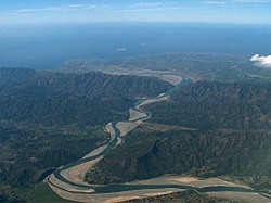 | |
 Abra River mouth | |
| Location | |
| Country | Philippines |
| Region | |
| Province | |
| Physical characteristics | |
| Source | Mount Data |
| • location | Benguet, Cordillera Administrative Region |
| • elevation | 2,310 m (7,580 ft) |
| Mouth | South China Sea |
• location | Caoayan, Ilocos Sur |
• coordinates | 17°30′47″N 120°23′45″E / 17.51306°N 120.39583°ECoordinates: 17°30′47″N 120°23′45″E / 17.51306°N 120.39583°E |
• elevation | 0 m (0 ft) |
| Length | 206 km (128 mi)[1] |
| Basin size | 5,125 km2 (1,979 sq mi)[2] |
| Discharge | |
| • average | 350 m3/s (12,000 cu ft/s) |
| Basin features | |
| Tributaries | |
| • right | |


The Abra River also called Lagben River is the seventh largest river system in the Philippines in terms of watershed size. It has an estimated drainage area of 5,125 square kilometres (1,979 sq mi) and a length of 206 kilometres (128 mi) from its source in the vicinity of Mount Data in Benguet province.[1]
Geography[]
The Abra originates in the southern section of Mount Data. It descends westward to Cervantes, Ilocos Sur, and flows into Abra. At a point near the municipality of Dolores, it is joined by the Tineg River, which originates in the uplands of Abra.[3]
References[]
- ^ a b Kenneth Kimutai too (24 July 2018). "Longest Rivers In The Philippines". worldatlas.com. WorldAtlas. Retrieved 6 September 2019.
- ^ Vicente B. Tuddao Jr. (September 21, 2011). "Water Quality Management in the Context of Basin Management: Water Quality, River Basin Management and Governance Dynamics in the Philippines" (PDF). www.wepa-db.net. Department of Environment and Natural Resources. Retrieved 10 April 2017.
- ^ DAMS IN THE CORDILLERA. internationalrivers.org
External links[]
![]() Media related to Abra River at Wikimedia Commons
Media related to Abra River at Wikimedia Commons
Categories:
- Rivers of the Philippines
- Landforms of Abra (province)
- Landforms of Ilocos Sur
- Asia river stubs
- Philippines geography stubs