Acy, Louisiana
This article needs additional citations for verification. (December 2019) |
Acy | |
|---|---|
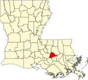
 Acy Location of Acy in Louisiana | |
| Coordinates: 30°13′08″N 90°49′13″W / 30.21889°N 90.82028°WCoordinates: 30°13′08″N 90°49′13″W / 30.21889°N 90.82028°W | |
| Country | United States |
| State | Louisiana |
| Parish | Ascension |
| Time zone | UTC-6 (CST) |
| • Summer (DST) | UTC-5 (CDT) |
| Area code(s) | 225 |

Acy is an unincorporated community in the southeastern part of Louisiana, United States.[1] Acy is located approximately 24 miles (39 km) southeast of Baton Rouge and 45 miles (72 km) northwest of New Orleans on Louisiana Highway 22 in the parish of Ascension.[2] The residents live along highways LA22, LA936, LA937, and many short parish side roads mostly named after current or past residents of the area. Acy consists of woodlands and pastures. Acy is a rural area located off a ridge surrounded by swamp lands. Its area is six miles (9.7 km) long and about one mile (1.6 km) wide.
References[]
- ^ "Acy Populated Place Profile / Ascension Parish, Louisiana Data". louisiana.hometownlocator.com. Retrieved 2019-05-21.
- ^ "Acy (Ascension Parish, Louisiana): Around the Neighborhood". roadsidethoughts.com. Retrieved 2019-05-21.
| show Municipalities and communities of Ascension Parish, Louisiana, United States |
|---|
| show Authority control |
|---|
This Louisiana state location article is a stub. You can help Wikipedia by . |
Categories:
- Unincorporated communities in Louisiana
- Baton Rouge metropolitan area
- Unincorporated communities in Ascension Parish, Louisiana
- Louisiana geography stubs