Sorrento, Louisiana
Sorrento, Louisiana | |
|---|---|
Town | |
 Location of Sorrento in Ascension Parish, Louisiana. | |
 Location of Louisiana in the United States | |
| Coordinates: 30°10′49″N 90°51′58″W / 30.18028°N 90.86611°WCoordinates: 30°10′49″N 90°51′58″W / 30.18028°N 90.86611°W | |
| Country | United States |
| State | Louisiana |
| Parish | Ascension |
| Incorporated | September 11, 1956 |
| Government | |
| • Mayor | Chris Guidry |
| Area | |
| • Total | 3.69 sq mi (9.55 km2) |
| • Land | 3.65 sq mi (9.44 km2) |
| • Water | 0.04 sq mi (0.11 km2) |
| Elevation | 7 ft (2 m) |
| Population (2010) | |
| • Total | 1,401 |
| • Estimate (2019)[2] | 1,704 |
| • Density | 467.49/sq mi (180.49/km2) |
| Time zone | UTC-6 (CST) |
| • Summer (DST) | UTC-5 (CDT) |
| Area code(s) | 225 |
| FIPS code | 22-71225 |
| Website | www |

Sorrento is a town in Ascension Parish, Louisiana, United States. The population was 1,227 at the 2000 census. By the 2010 census it had grown 14.2%, to 1,401 inhabitants. It is part of the Baton Rouge Metropolitan Statistical Area.
Geography[]
Sorrento is located at 30°10′49″N 90°51′58″W / 30.18028°N 90.86611°W (30.180229, -90.866138).[3]
According to the United States Census Bureau, the town has a total area of 3.1 square miles (8.1 km2), all land.
Demographics[]
| Historical population | |||
|---|---|---|---|
| Census | Pop. | %± | |
| 1960 | 1,151 | — | |
| 1970 | 1,182 | 2.7% | |
| 1980 | 1,197 | 1.3% | |
| 1990 | 1,119 | −6.5% | |
| 2000 | 1,227 | 9.7% | |
| 2010 | 1,401 | 14.2% | |
| 2019 (est.) | 1,704 | [2] | 21.6% |
| U.S. Decennial Census[4] | |||
2020 census[]
| Race | Number | Percentage |
|---|---|---|
| White (non-Hispanic) | 1,085 | 71.66% |
| Black or African American (non-Hispanic) | 253 | 16.71% |
| Native American | 7 | 0.46% |
| Asian | 10 | 0.66% |
| Pacific Islander | 1 | 0.07% |
| Other/Mixed | 45 | 2.97% |
| Hispanic or Latino | 113 | 7.46% |
As of the 2020 United States census, there were 1,514 people, 634 households, and 417 families residing in the town.
2000 census[]
As of the census[6] of 2000, there were 1,227 people, 446 households, and 337 families residing in the town. The population density was 392.5 people per square mile (151.4/km2). There were 494 housing units at an average density of 158.0 per square mile (60.9/km2). The racial makeup of the town was 83.70% White, 14.83% African American, 0.41% Native American, 0.08% Asian, 0.41% from other races, and 0.57% from two or more races. Hispanic or Latino of any race were 1.39% of the population.
There were 446 households, out of which 37.4% had children under the age of 18 living with them, 59.6% were married couples living together, 10.8% had a female householder with no husband present, and 24.4% were non-families. 19.7% of all households were made up of individuals, and 7.0% had someone living alone who were 65 years of age or older. The average household size was 2.75 and the average family size was 3.20.
In the town, the population was spread out, with 28.3% under the age of 18, 9.5% from 18 to 24, 31.1% from 25 to 44, 20.6% from 45 to 64, and 10.4% who were 65 years of age or older. The median age was 34 years. For every 100 females, there were 103.8 males. For every 100 females age 18 and over, there were 97.8 males.
The median income for a household in the town was $35,234, and the median income for a family was $40,208. Males had a median income of $35,662 versus $20,625 for females. The per capita income for the town was $14,803. About 14.2% of families and 16.0% of the population were below the poverty line, including 15.8% of those under age 18 and 20.3% of those age 65 or over.
Education and media[]
Sorrento Primary School (K-5)
Sorrento is home to River Parishes Community College, established in 1998.[7]
The official journal for the Town of Sorrento is The Gonzales Weekly Citizen.
Notable people[]
- Clay Schexnayder, member of the Louisiana House of Representatives from Ascension Parish, owns an automotive repair business in Sorrento.[8]
- John "Hot Rod" Williams, NBA player
- Toe Nash, retired MLB player
References[]
- ^ "2019 U.S. Gazetteer Files". United States Census Bureau. Retrieved July 25, 2020.
- ^ a b "Population and Housing Unit Estimates". United States Census Bureau. May 24, 2020. Retrieved May 27, 2020.
- ^ "US Gazetteer files: 2010, 2000, and 1990". United States Census Bureau. 2011-02-12. Retrieved 2011-04-23.
- ^ "Census of Population and Housing". Census.gov. Retrieved June 4, 2015.
- ^ "Explore Census Data". data.census.gov. Retrieved 2021-12-28.
- ^ "U.S. Census website". United States Census Bureau. Retrieved 2008-01-31.
- ^ http://www.rpcc.edu/aboutUs.cfm - History of the College; accessed 27 Oct 2015.
- ^ "Schexnayder Announces Candidacy". clayschexnayder.com. Archived from the original on July 7, 2012. Retrieved May 16, 2012.
External links[]
- The About Us – History of the College page for River Parishes Community College contains Facts about the Sorrento area, including the town's history.
Municipalities and communities of Ascension Parish, Louisiana, United States | ||
|---|---|---|
Parish seat: Donaldsonville | ||
| Cities | 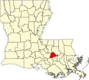 | |
| Town | ||
| CDPs | ||
| Other unincorporated communities | ||
| Footnotes | ‡This populated place also has portions in an adjacent parish or parishes | |
| ||
| Authority control |
|
|---|
- Towns in Louisiana
- Towns in Ascension Parish, Louisiana
- Baton Rouge metropolitan area