Agra, Kansas
Agra, Kansas | |
|---|---|
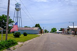 Center Street (2021) | |
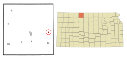 Location within Phillips County and Kansas | |
 | |
| Coordinates: 39°45′38″N 99°7′11″W / 39.76056°N 99.11972°WCoordinates: 39°45′38″N 99°7′11″W / 39.76056°N 99.11972°W[1] | |
| Country | United States |
| State | Kansas |
| County | Phillips |
| Founded | 1888 |
| Incorporated | 1904 |
| Named for | Agra |
| Area | |
| • Total | 0.25 sq mi (0.65 km2) |
| • Land | 0.25 sq mi (0.65 km2) |
| • Water | 0.00 sq mi (0.00 km2) |
| Elevation | 1,850 ft (560 m) |
| Population | |
| • Total | 208 |
| • Density | 830/sq mi (320/km2) |
| Time zone | UTC-6 (CST) |
| • Summer (DST) | UTC-5 (CDT) |
| ZIP code | 67621 |
| Area code | 785 |
| FIPS code | 20-00550 [1] |
| GNIS ID | 471935 [1] |

Agra is a city in Phillips County, Kansas, United States.[1] As of the 2020 census, the population of the city was 208.[3]
History[]
Agra was first settled in 1888, and incorporated in 1904.[4] Agra was a station on the Chicago, Rock Island and Pacific Railroad.[5] It was named for Agra in India.[6]
Geography[]
Agra is located at 39°45′38″N 99°7′11″W / 39.76056°N 99.11972°W (39.760686, -99.119592).[7] According to the United States Census Bureau, the city has a total area of 0.27 square miles (0.70 km2), all land.[8]
Demographics[]
| Historical population | |||
|---|---|---|---|
| Census | Pop. | %± | |
| 1910 | 347 | — | |
| 1920 | 361 | 4.0% | |
| 1930 | 408 | 13.0% | |
| 1940 | 406 | −0.5% | |
| 1950 | 354 | −12.8% | |
| 1960 | 277 | −21.8% | |
| 1970 | 294 | 6.1% | |
| 1980 | 321 | 9.2% | |
| 1990 | 322 | 0.3% | |
| 2000 | 306 | −5.0% | |
| 2010 | 267 | −12.7% | |
| 2020 | 208 | −22.1% | |
| U.S. Decennial Census | |||
2010 census[]
As of the census[9] of 2010, there were 267 people, 116 households, and 78 families residing in the city. The population density was 988.9 inhabitants per square mile (381.8/km2). There were 162 housing units at an average density of 600.0 per square mile (231.7/km2). The racial makeup of the city was 95.1% White, 0.4% African American, 1.9% Native American, 0.4% Asian, and 2.2% from two or more races. Hispanic or Latino of any race were 2.2% of the population.
There were 116 households, of which 25.0% had children under the age of 18 living with them, 56.0% were married couples living together, 6.0% had a female householder with no husband present, 5.2% had a male householder with no wife present, and 32.8% were non-families. 30.2% of all households were made up of individuals, and 13.8% had someone living alone who was 65 years of age or older. The average household size was 2.30 and the average family size was 2.86.
The median age in the city was 49.4 years. 23.2% of residents were under the age of 18; 6.4% were between the ages of 18 and 24; 14.6% were from 25 to 44; 36.7% were from 45 to 64; and 19.1% were 65 years of age or older. The gender makeup of the city was 51.3% male and 48.7% female.
2000 census[]
As of the census[10] of 2000, there were 306 people, 131 households, and 89 families residing in the city. The population density was 1,099.6 people per square mile (422.0/km2). There were 173 housing units at an average density of 621.7 per square mile (238.6/km2). The racial makeup of the city was 98.69% White, 0.33% Native American, and 0.98% from two or more races. Hispanic or Latino of any race were 0.65% of the population.
There were 131 households, out of which 31.3% had children under the age of 18 living with them, 56.5% were married couples living together, 9.9% had a female householder with no husband present, and 31.3% were non-families. 29.8% of all households were made up of individuals, and 14.5% had someone living alone who was 65 years of age or older. The average household size was 2.34 and the average family size was 2.89.
In the city, the population was spread out, with 28.4% under the age of 18, 3.9% from 18 to 24, 24.5% from 25 to 44, 26.5% from 45 to 64, and 16.7% who were 65 years of age or older. The median age was 39 years. For every 100 females, there were 91.3 males. For every 100 females age 18 and over, there were 90.4 males.
The median income for a household in the city was $27,250, and the median income for a family was $36,250. Males had a median income of $26,944 versus $16,429 for females. The per capita income for the city was $16,960. About 8.5% of families and 10.7% of the population were below the poverty line, including 11.3% of those under the age of eighteen and 7.7% of those 65 or over.
Education[]
The community is served by Thunder Ridge USD 110 public school district, where schools are located in Kensington and Agra.[11] In 2008 West Smith County USD 238 and Eastern Heights USD 324 combined to form Thunder Ridge USD 110.[12] The Thunder Ridge High School mascot is the Thunder Ridge Longhorns.[13]
Agra schools were closed through school unification. The Agra High School mascot was Agra Purple Chargers.[14]
References[]
- ^ a b c d e "Agra, Kansas", Geographic Names Information System, United States Geological Survey
- ^ "2019 U.S. Gazetteer Files". United States Census Bureau. Retrieved July 24, 2020.
- ^ a b "Profile of Agra, Kansas in 2020". United States Census Bureau. Archived from the original on March 16, 2022. Retrieved March 16, 2022.
- ^ Blackmar, Frank Wilson (1912). Kansas: A Cyclopedia of State History, Embracing Events, Institutions, Industries, Counties, Cities, Towns, Prominent Persons, Etc. Standard Publishing Company. pp. 32.
- ^ Gannett, Henry (1898). A Gazetteer of Kansas. Govt. Print. Off. p. 24.
- ^ Stewart, George R. (1970). American place-names; a concise and selective dictionary for the continental United States of America. New York: Oxford University Press.
- ^ "US Gazetteer files: 2010, 2000, and 1990". United States Census Bureau. 2011-02-12. Retrieved 2011-04-23.
- ^ "US Gazetteer files 2010". United States Census Bureau. Archived from the original on 2012-01-25. Retrieved 2012-07-06.
- ^ "U.S. Census website". United States Census Bureau. Retrieved 2012-07-06.
- ^ "U.S. Census website". United States Census Bureau. Retrieved 2008-01-31.
- ^ "USD 110 Map" (PDF). Kansas Department of Transportation. Retrieved 2020-04-29.
- ^ "School consolidations in Kansas for past decade". The Topeka Capital-Journal. 2011-07-24. Retrieved 2020-04-26.
- ^ "USD 110 Thunder Ridge". USD 110. Retrieved 1 January 2017.
- ^ "Agra Captures P and R Crown", The Salina Journal, 16 November 1955, p.13.
Further reading[]
External links[]
| Wikimedia Commons has media related to Agra, Kansas. |
Municipalities and communities of Phillips County, Kansas, United States | ||
|---|---|---|
| Cities |  | |
| Unincorporated communities | ||
| Ghost towns | ||
| Footnotes | †This community is designated a Census-Designated Place (CDP) by the United States Census Bureau. | |
| ||
- Cities in Kansas
- Cities in Phillips County, Kansas
- 1888 establishments in Kansas
- Populated places established in 1888