Aim Rocks
 Location of Morton Strait in the South Shetland Islands. | |
 Aim Rocks Location of Aim Rocks | |
| Geography | |
|---|---|
| Location | Antarctica |
| Coordinates | 62°41′43.6″S 61°15′50.6″W / 62.695444°S 61.264056°WCoordinates: 62°41′43.6″S 61°15′50.6″W / 62.695444°S 61.264056°W |
| Administration | |
| Administered under the Antarctic Treaty System | |
| Demographics | |
| Population | Uninhabited |


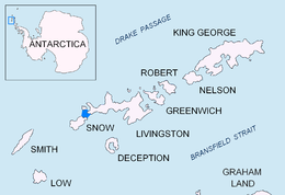
Aim Rocks is a group of rocks lying east of Cape Timblón in the middle of Morton Strait in the South Shetland Islands, Antarctica. The name, given by the United Kingdom Antarctic Place-Names Committee in 1961, is descriptive; these rocks in line are a guide for safe passage through the southern entrance of Morton Strait.
See also[]
Maps[]
- L.L. Ivanov et al. Antarctica: Livingston Island and Greenwich Island, South Shetland Islands. Scale 1:100000 topographic map. Sofia: Antarctic Place-names Commission of Bulgaria, 2005.
- L.L. Ivanov. Antarctica: Livingston Island and Greenwich, Robert, Snow and Smith Islands. Scale 1:120000 topographic map. Troyan: Manfred Wörner Foundation, 2009. ISBN 978-954-92032-6-4
References[]
![]() This article incorporates public domain material from the United States Geological Survey document: "Aim Rocks". (content from the Geographic Names Information System)
This article incorporates public domain material from the United States Geological Survey document: "Aim Rocks". (content from the Geographic Names Information System)

Topographic map of Livingston Island, Greenwich, Robert, Snow and Smith Islands.
Antarctica | ||
|---|---|---|
| General |
|  |
| Regions |
| |
| Waterways |
| |
| Famous explorers |
| |
This Snow Island location article is a stub. You can help Wikipedia by . |
Categories:
- Rock formations of Antarctica
- Snow Island (South Shetland Islands) geography stubs