Waldseemüller Rock
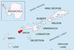 Location of Snow Island in the South Shetland Islands | |
 Waldseemüller Rock Location of Waldseemüller Rock | |
| Geography | |
|---|---|
| Location | Antarctica |
| Coordinates | 62°51′52″S 61°26′31″W / 62.86444°S 61.44194°W |
| Archipelago | South Shetland Islands |
| Area | 0.48 ha (1.2 acres) |
| Length | 136 m (446 ft) |
| Width | 53 m (174 ft) |
| Administration | |
| Administered under the Antarctic Treaty | |
| Demographics | |
| Population | uninhabited |


Waldseemüller Rock (Bulgarian: скала Валдзеемюлер, romanized: skala Waldseemüller, IPA: [skɐˈla ˈvaldzɛɛmʲulɛr]) is the rock off the south extremity of Snow Island in the South Shetland Islands, Antarctica 136 m long in west-east direction and 53 m wide, with a surface area of 0.48 ha. The vicinity was visited by early 19th century sealers.[1]
The feature is named after Martin Waldseemüller (c. 1470-1520), a German cartographer and topographer who created an early forerunner of the theodolite; in association with other names in the area deriving from the early development or use of geodetic instruments and methods.
Location[]
Waldseemüller Rock is located at 62°51′52″S 61°26′31″W / 62.86444°S 61.44194°WCoordinates: 62°51′52″S 61°26′31″W / 62.86444°S 61.44194°W,[2] which is 2.5 km south by west of Cape Conway and 930 m southwest of Tooth Rock. Bulgarian mapping in 2009.
See also[]
Maps[]
- South Shetland Islands. Scale 1:200000 topographic map. DOS 610 Sheet W 62 60. Tolworth, UK, 1968
- L. Ivanov. Antarctica: Livingston Island and Greenwich, Robert, Snow and Smith Islands. Scale 1:120000 topographic map. Troyan: Manfred Wörner Foundation, 2010. ISBN 978-954-92032-9-5 (First edition 2009. ISBN 978-954-92032-6-4)
- Antarctic Digital Database (ADD). Scale 1:250000 topographic map of Antarctica. Scientific Committee on Antarctic Research (SCAR). Since 1993, regularly upgraded and updated
Notes[]
- ^ L. Ivanov. General Geography and History of Livingston Island. In: Bulgarian Antarctic Research: A Synthesis. Eds. C. Pimpirev and N. Chipev. Sofia: St. Kliment Ohridski University Press, 2015. pp. 17–28
- ^ Bulgarian Antarctic Gazetteer. Antarctic Place-names Commission
References[]
- Bulgarian Antarctic Gazetteer. Antarctic Place-names Commission. (details in Bulgarian, basic data in English)
External links[]
- Waldseemüller Rock. Adjusted Copernix satellite image
This article includes information from the Antarctic Place-names Commission of Bulgaria which is used with permission.
This Snow Island location article is a stub. You can help Wikipedia by . |
- Snow Island (South Shetland Islands)
- Rock formations of the South Shetland Islands
- Bulgaria and the Antarctic
- Snow Island (South Shetland Islands) geography stubs