Albuquerque metropolitan area
Albuquerque Metropolitan Area | |
|---|---|
  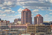         (top-to-bottom, left-to-right) Panorama of the city of Albuquerque; San Felipe de Neri Church in Old Town Albuquerque; Downtown Albuquerque; Fred Harvey Company Harvey House museum in Belen; Moriarty municipal; Los Lunas; Intel Fab 11x in Rio Rancho; village hall in Los Ranchos; Rio Grande Bosque near Bernalillo; U.S. Route 66 in New Mexico; panorama from the Sandia Mountains peak | |
 | |
| Coordinates: 35°06′39″N 106°36′36″W / 35.11083°N 106.61000°WCoordinates: 35°06′39″N 106°36′36″W / 35.11083°N 106.61000°W | |
| National | United States |
| States | |
| Statistical Area | Albuquerque-Santa Fe-Las Vegas, NM Combined Statistical Area |
| Principal counties (cities) | |
| Area | |
| • Total | 9,297 sq mi (24,080 km2) |
| Elevation (Average height) | 5,312 ft (1,619 m) |
| Highest elevation (Sandia Mountains Crest) | 10,678 ft (3,255 m) |
| Lowest elevation (Near the Rio Grande, south of Jarales) | 4,767 ft (1,453 m) |
| Population | |
| • Total | 915,927[1] |
| • Density | 95/sq mi (37/km2) |
| Time zone | UTC−7 (Mountain Time Zone) |
| • Summer (DST) | UTC−6 (Mountain Daylight Time) |

The Albuquerque Metropolitan Statistical Area is a metropolitan area in central New Mexico centered on the city of Albuquerque comprising four counties: Bernalillo, Sandoval, Torrance, and Valencia. As of the 2010 United States Census, the MSA had a population of 887,077.[2] The population is estimated to be 923,630 as of July 1, 2020,[3] making Greater Albuquerque the 61st-largest MSA in the nation. The Albuquerque MSA forms a part of the larger Albuquerque–Santa Fe–Las Vegas combined statistical area with a 2020 estimated population of 1,165,181, ranked 49th-largest in the country.
Counties[]
- Bernalillo
- Sandoval
- Torrance
- Valencia
Communities[]
Cities[]
- Albuquerque (Principal city)
- Belen
- Moriarty
- Rio Communities
- Rio Rancho
Towns[]
Villages[]
- Bosque Farms
- Corrales
- Cuba
- Encino
- Jemez Springs
- Los Lunas
- Los Ranchos de Albuquerque
- San Ysidro
- Tijeras
- Willard
Census-designated places[]
- Algodones
- Carnuel
- Casa Colorada
- Cedar Crest
- Chilili
- Cochiti
- El Cerro-Monterey Park
- Isleta Village Proper
- Jarales
- Jemez Pueblo
- La Jara
- Los Chavez
- Los Trujillos-Gabaldon
- Manzano
- Meadow Lake
- North Valley
- Paradise Hills
- Pena Blanca
- Placitas
- Ponderosa
- Pueblo of Sandia Village
- Regina
- Rio Communities North
- Rio Communities
- San Felipe Pueblo
- Santa Ana Pueblo
- Santo Domingo Pueblo
- South Valley
- Tajique
- Tome-Adelino
- Torreon (Sandoval County)
- Torreon (Torrance County)
- Valencia
- Zia Pueblo
Partial inclusions and future developments[]
Neighboring Laguna Pueblo borders the metropolitan area, and part of its boundaries are included the metropolitan population. Most notably the area surrounding Route 66 Resort and Casino.
Mesa del Sol in Albuquerque and Santolina on the West Mesa in rural Bernalillo County are planned for 100,000 inhabitants each and are New Mexico's largest such planned developments.[4][5]
Demographics[]
| Historical population | |||
|---|---|---|---|
| Census | Pop. | %± | |
| 1900 | 28,630 | — | |
| 1910 | 23,606 | −17.5% | |
| 1920 | 29,855 | 26.5% | |
| 1930 | 45,430 | 52.2% | |
| 1940 | 69,391 | 52.7% | |
| 1950 | 145,675 | 109.9% | |
| 1960 | 321,982 | 121.0% | |
| 1970 | 379,085 | 17.7% | |
| 1980 | 523,105 | 38.0% | |
| 1990 | 599,416 | 14.6% | |
| 2000 | 729,649 | 21.7% | |
| 2010 | 887,077 | 21.6% | |
| 2019 (est.) | 918,018 | 3.5% | |
| U.S. Decennial Census[6][7] | |||
As of the 2010 United States Census, there were 887,077 people, 347,366 households, and 222,811 families residing within the MSA. The racial makeup of the MSA was 69.63% White, 2.68% African American, 5.86% Native American, 2.02% Asian, 0.10% Pacific Islander, 15.40% from one other race, and 4.32% from two or more races. Hispanic or Latino of any race were 46.70% of the population.
The median income for a household in the MSA was $47,383 and the median income for a family was $59,158. Males had a median income of $31,486 versus $20,497 for females. The per capita income for the MSA was $25,044.[8]
According to 2014-2018 census data, 89.7% of the population was a high school graduate or higher, and 34.7% had a bachelor's degree or higher.[9]
Labor force[]
Albuquerque MSA Estimated Employment (August 2006)
| Bernalillo County | 304,855 |
| Sandoval County | 48,055 |
| Torrance County | 16,021 |
| Valencia County | 30,591 |
| Total | 399,522 |
| Source: New Mexico Department of Labor [10] | |
See also[]
- List of metropolitan areas in New Mexico
- List of micropolitan areas in New Mexico
- List of cities in New Mexico
| Wikimedia Commons has media related to Albuquerque metropolitan area. |
References[]
- ^ "Demographics". Albuquerque Business Expansion | Business Friendly Environment | Albuquerque Economic Development AED. Retrieved February 22, 2015.
- ^ "Census data" (PDF). www.census.gov. 2010. Retrieved 2020-04-13.
- ^ List of Metropolitan Statistical Areas
- ^ Metcalf, Richard (March 1, 2008). "Mesa del Sol Reshapes Region". nreionline.com. Retrieved Mar 1, 2008.
- ^ "Santolina Master Plan". www.bernco.gov.
- ^ "U.S. Decennial Census". United States Census Bureau. Archived from the original on May 12, 2015. Retrieved May 28, 2013.
- ^ "Cumulative Estimates of Resident Population Change and Rankings for Metropolitan Statistical Areas in the United States and Puerto Rico: April 1, 2010 to July 1, 2019" (PDF). United States Census Bureau. 2019. Retrieved May 31, 2020.
- ^ "Explore Census Data". United States Census Bureau. Retrieved 26 May 2020.
- ^ "Demographics". City of Albuquerque. Retrieved 2021-01-20.
- ^ "New Mexico Department of Labor". Archived from the original on 2000-05-10. Retrieved 2020-04-13.
| show City of Albuquerque, New Mexico |
|---|


| show Authority control |
|---|
- Albuquerque metropolitan area
- Albuquerque, New Mexico
- Metropolitan areas of New Mexico
- Geography of Bernalillo County, New Mexico
- Geography of Sandoval County, New Mexico
- Geography of Torrance County, New Mexico
- Geography of Valencia County, New Mexico