Amalia, New Mexico
Amalia, New Mexico | |
|---|---|
 The post office in Amalia | |
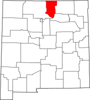
 Amalia, New Mexico Location of Amalia in New Mexico and the United States | |
| Coordinates: 36°56′31″N 105°27′16″W / 36.94194°N 105.45444°W | |
| Country | United States |
| States | New Mexico |
| County | Taos |
| Government | |
| • Type | unincorporated community |
| Elevation | 8,146 ft (2,483 m) |
| Time zone | UTC−7 (Mountain (MST)) |
| • Summer (DST) | UTC−6 (MDT) |
| ZIP code | 87512 |
| Area code(s) | 575 |
| Website | amalianm |
Amalia is an unincorporated community in Taos County, New Mexico, United States. Amalia is located near the Colorado border, on New Mexico State Road 196. The elevation is 8,143 feet (2,482 meters).[1]
Amalia has a post office, with the ZIP code 87512. The 87512 ZIP Code Tabulation Area had a population of 230 at the 2000 census.
History[]

Amalia was formerly known as Pina. A post office was established in 1900, before being renamed Amalia in 1919.[2]
In summer of 2018, at a remote site with a small camping trailer within a surrounding wall of car tires, five adults, 11 hungry children (ages 1 to 15), and later a dead child, were found. Court documents stated the children had been trained for shootings at schools.[3][4] Federal terrorism, kidnapping, and firearms charges were brought against five adults in March 2019.[5]
References[]
- ^ "Amalia". Geographic Names Information System. United States Geological Survey.
- ^ Julyan, Robert (1996). The Place Names of New Mexico. University of New Mexico Press. p. 14. ISBN 0826316891.
- ^ Prosecutor: Man at New Mexico compound trained kids for school shooting timesofisrael.com, 9 August 2018.
- ^ New Mexico compound suspects were training children for school shootings, prosecutors say cnn.com, 8 August 2018.
- ^ Caitlin Yilek (March 15, 2019). "New Mexico compound was alleged terrorist training camp to kill US officers". Washington Examiner. Retrieved March 15, 2019.
Assistant Attorney General John Demers said those attacks were being planned against federal law enforcement officers and members of the military.
External links[]
Coordinates: 36°56′31″N 105°27′16″W / 36.94194°N 105.45444°W
- Unincorporated communities in New Mexico
- Unincorporated communities in Taos County, New Mexico
- Terrorist training camps
- New Mexico geography stubs


