Ampanefena
Ampanefena | |
|---|---|
 | |
 Ampanefena Location in Madagascar | |
| Coordinates: 13°52′S 49°58′E / 13.867°S 49.967°E | |
| Country | |
| Region | Sava |
| District | Vohemar |
| Elevation | 58 m (190 ft) |
| Population (2008) | |
| • Total | 13,000 |
| Time zone | UTC3 (EAT) |

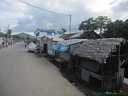
Ampanefena is a town and commune (Malagasy: kaominina) in northern Madagascar. It belongs to the district of Vohemar, which is a part of Sava Region. In 2008 its population was estimated to 23.000.[2]
Primary and junior level secondary education are available in town. The majority 98% of the population of the commune are farmers, while an additional 1% receives their livelihood from raising livestock. The most important crop is vanilla, while other important products are coffee and rice. Industry and services provide both employment for 0.5% of the population.[3]
Geography[]
The town is situated at the Route nationale 5a between Vohemar and Sambava.
References and notes[]
- ^ Estimated based on DEM data from Shuttle Radar Topography Mission
- ^ www.pseau.org
- ^ "ILO census data". Cornell University. 2002. Retrieved 2008-02-25.
Capital: Sambava | ||
| Andapa (17) |  | |
| Antalaha (14) |
| |
| Sambava (25) | ||
| Vohemar (19) | ||
4 districts; 75 communes | ||
Coordinates: 13°52′S 49°58′E / 13.867°S 49.967°E
This Sava region of Madagascar location article is a stub. You can help Wikipedia by . |
- Populated places in Sava Region
- Sava Region geography stubs