Vohemar District
Vohemar District | |
|---|---|
District | |
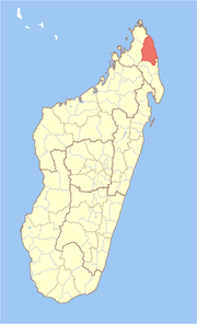 Location in Madagascar | |
| Coordinates: 13°19′S 49°43′E / 13.317°S 49.717°E | |
| Country | |
| Region | Sava |
| Area | |
| • Total | 8,268.55 km2 (3,192.51 sq mi) |
| Population (2013) | |
| • Total | 255,080 |
| • Density | 31/km2 (80/sq mi) |
| • Ethnicities | Antankarana |
| Time zone | UTC3 (EAT) |

Vohemar District (also Vohimarina District) is a district in northern Madagascar. It is a part of Sava Region and borders the districts of Sambava to the south, Ambilobe to the west and Antsiranana II to the north. The area is 8,268.55 km2 (3,193 sq mi) and the population was estimated to be 255,080 in 2013.[1] Its capitol is Vohemar.
Communes[]
The district is further divided into 19 communes:
- Ambalasatrana
- Ambinanin'andravory
- Amboriala
- Ampanefena
- Ampisikina
- Ampondra
- Andrafainkona
- Andravory
- Antsahavaribe
- Antsirabe Nord
- Belambo
- Bobakindro
- Daraina
- Fanambana
- Maromokotra
- Milanoa
- Nosibe
- Tsarabaria
- Vohemar
References and notes[]
- ^ Institutr Nationalde la Statistique, Antananarivo.
Coordinates: 13°19′S 49°43′E / 13.317°S 49.717°E
Capital: Sambava | ||
| Andapa (17) |  | |
| Antalaha (14) |
| |
| Sambava (25) | ||
| Vohemar (19) | ||
4 districts; 75 communes | ||
This Sava region of Madagascar location article is a stub. You can help Wikipedia by . |
Categories:
- Sava Region geography stubs
- Districts of Sava Region