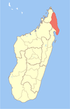
Sarahandrano
This article relies largely or entirely on a single source. (May 2015) |
Sarahandrano | |
|---|---|
 Sarahandrano Location in Madagascar | |
| Coordinates: 14°47′S 50°1′E / 14.783°S 50.017°E | |
| Country | |
| Region | Sava |
| District | Antalaha |
| Population (2001)[1] | |
| • Total | 12,758 |
| Time zone | UTC3 (EAT) |
Sarahandrano is a commune (Malagasy: kaominina) in northern Madagascar. It belongs to the district of Antalaha, which is a part of Sava Region. According to 2001 census the population of Sarahandrano was 12,758.[1]
Primary and junior level secondary education are available in town. The majority 99% of the population are farmers.[citation needed] The most important crops are rice and vanilla; also coffee is an important agricultural product. Services provide employment for 1% of the population.[1]
Notes[]
- ^ Jump up to: a b c "ILO census data". Cornell University. 2002. Retrieved 2008-02-15.
Coordinates: 14°47′S 50°1′E / 14.783°S 50.017°E
Categories:
- Populated places in Sava Region
- Sava Region geography stubs

