Anjum
Anjum
Eanjum | |
|---|---|
Village | |
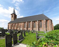 The 12th-century Protestant church of Anjum (2008) | |
 Flag  Coat of arms | |
 Location in the former Dongeradeel municipality | |
 Anjum Location in the Netherlands | |
| Coordinates: Coordinates: 53°22′29″N 6°07′38″E / 53.37472°N 6.12722°E | |
| Country | |
| Province | |
| Municipality | Noardeast-Fryslân |
| Population (2017) | |
| • Total | 1,136 |
| Time zone | UTC+1 (CET) |
| • Summer (DST) | UTC+2 (CEST) |
| Postal code | 9133 |
| Telephone area | 0519 |

Anjum (West Frisian: Eanjum) is a village in the Dutch province of Friesland. It is located in the municipality Noardeast-Fryslân and had, as of January 2017, a population of 1136.[1]
History[]
The name of the village is often said to mean "home of the Anos or Aningas". Another explanation is that it comes from the word "Hanjum" (corner). It is thought that Anjum's surroundings were once much more densely populated.
The terp of Anjum was set up on a then-existing marsh ridge and, in the course of time got bigger and bigger. The village frequently suffered floods. The All Saints' Flood (1570) claimed hundreds of victims, and the Christmas flood of 1717 drowned 53.
From 1913 to 1935 Anjum was the terminus of the North Friesland Railway. The line reopened in May 1940 and closed in July 1942. The station building still stands.
Before 2019, the village was part of the Dongeradeel municipality.

Windmill De Eendracht

References[]
- ^ Aantal inwoners per woonplaats in Dongeradeel op 1 januari 2017 Archived 2017-10-21 at the Wayback Machine - Dongeradeel
External links[]
![]() Media related to Anjum at Wikimedia Commons
Media related to Anjum at Wikimedia Commons
This Friesland location article is a stub. You can help Wikipedia by . |
- Noardeast-Fryslân
- Populated places in Friesland
- Friesland geography stubs