Hallum
Hallum | |
|---|---|
Village | |
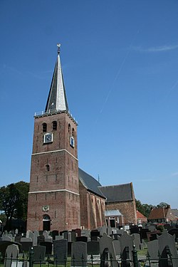 St Martin's church | |
 Flag  Coat of arms | |
 Location in the Ferwerderadiel municipality | |
 Hallum Location in the Netherlands | |
| Coordinates: Coordinates: 53°19′N 5°47′E / 53.317°N 5.783°E | |
| Country | |
| Province | |
| Municipality | Noardeast-Fryslân |
| Population (2017) | |
| • Total | 2,746 |
| Time zone | UTC+1 (CET) |
| • Summer (DST) | UTC+2 (CEST) |
| Postal code | 9074 |
| Telephone area | 0518 |

Hallum is a village in the province of Friesland, the Netherlands. It is a village in the municipality of Noardeast-Fryslân and it had a population of around 2,746 in January 2017.[1] Before 2019, the village was part of the Ferwerderadiel municipality.
The primary language spoken there is West Frisian. Hallum is also a relatively uncommon family name. There was a station on the North Friesland Railway which opened in 1901 and closed in 1935, although it reopened between May 1940 and July 1942. A restored windmill used to stand near the village. In 2000 it got moved to Burgwerd due to expanding industry and renamed "Aylvapoldermolen".
Like many towns in the region, it was built on land recovered from the North Sea. There was a standard layout for these towns. The center of the town was called the Terp. The Terp was the highest prominence in the town, and the streets radiated outward, like ripples on a pond, and were intersected by streets which reached out from the center, like spokes on a bike.
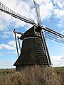
Windmill Genezareth
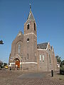
De Hoeksteen


Notable people[]
- Barthold Douma van Burmania (1695-1766) - Dutch statesman and ambassador to the court of Vienna
References[]
- ^ Aantal inwoners per woonplaats in Ferwerderadiel op 1 januari 2017 Archived 2017-10-21 at the Wayback Machine - Ferwerderadiel
External links[]
![]() Media related to Hallum at Wikimedia Commons
Media related to Hallum at Wikimedia Commons
This Friesland location article is a stub. You can help Wikipedia by . |
- Noardeast-Fryslân
- Populated places in Friesland
- Friesland geography stubs